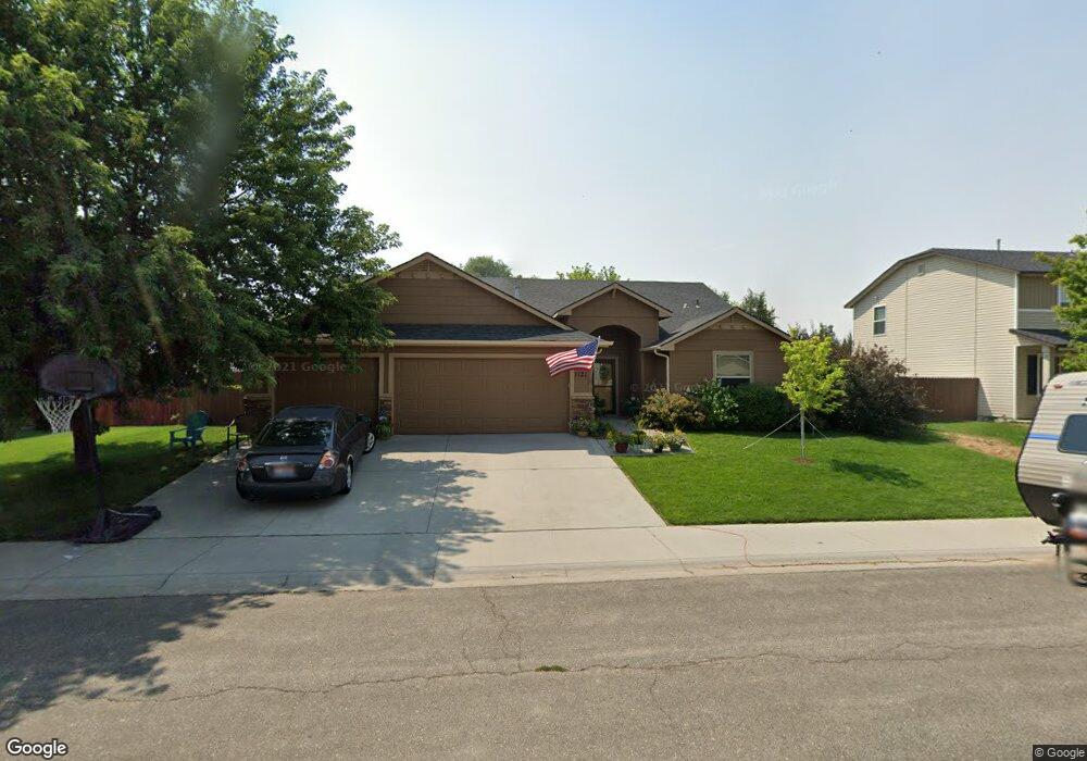
1121 SW Independence Mountain Home, ID 83647
Estimated Value: $370,000 - $411,000
3
Beds
2
Baths
1,713
Sq Ft
$224/Sq Ft
Est. Value
About This Home
This home is located at 1121 SW Independence, Mountain Home, ID 83647 and is currently estimated at $384,328, approximately $224 per square foot. 1121 SW Independence is a home located in Elmore County with nearby schools including West Elementary School, Mountain Home Junior High School, and Hacker Middle School.
Ownership History
Date
Name
Owned For
Owner Type
Purchase Details
Closed on
Mar 7, 2017
Sold by
Crownhart Christopher Colin
Bought by
Crownhart Christopher C and Crownhart Kristy D
Current Estimated Value
Home Financials for this Owner
Home Financials are based on the most recent Mortgage that was taken out on this home.
Original Mortgage
$167,868
Outstanding Balance
$139,282
Interest Rate
4.19%
Mortgage Type
VA
Estimated Equity
$245,046
Purchase Details
Closed on
Dec 3, 2008
Sold by
Trillium Custom Homes Llc
Bought by
Crownhart Christopher Colin
Home Financials for this Owner
Home Financials are based on the most recent Mortgage that was taken out on this home.
Original Mortgage
$184,380
Interest Rate
6.04%
Mortgage Type
VA
Purchase Details
Closed on
Jul 9, 2008
Sold by
Edmonds And Urwin Development Llc
Bought by
Trillium Custom Homes Llc
Create a Home Valuation Report for This Property
The Home Valuation Report is an in-depth analysis detailing your home's value as well as a comparison with similar homes in the area
Home Values in the Area
Average Home Value in this Area
Purchase History
| Date | Buyer | Sale Price | Title Company |
|---|---|---|---|
| Crownhart Christopher C | -- | Alliance Title | |
| Crownhart Christopher Colin | -- | -- | |
| Trillium Custom Homes Llc | -- | -- |
Source: Public Records
Mortgage History
| Date | Status | Borrower | Loan Amount |
|---|---|---|---|
| Open | Crownhart Christopher C | $167,868 | |
| Closed | Crownhart Christopher Colin | $184,380 |
Source: Public Records
Tax History Compared to Growth
Tax History
| Year | Tax Paid | Tax Assessment Tax Assessment Total Assessment is a certain percentage of the fair market value that is determined by local assessors to be the total taxable value of land and additions on the property. | Land | Improvement |
|---|---|---|---|---|
| 2024 | $2,242 | $390,494 | $52,200 | $338,294 |
| 2023 | $2,242 | $387,976 | $40,500 | $347,476 |
| 2022 | $2,733 | $372,071 | $37,530 | $334,541 |
| 2021 | $2,173 | $274,214 | $31,320 | $242,894 |
| 2020 | $2,046 | $222,233 | $26,100 | $196,133 |
| 2019 | $1,937 | $196,462 | $26,100 | $170,362 |
| 2018 | $1,800 | $163,034 | $21,736 | $141,298 |
| 2017 | $1,762 | $153,313 | $21,736 | $131,577 |
| 2016 | $1,716 | $147,332 | $21,736 | $125,596 |
| 2015 | $1,749 | $0 | $0 | $0 |
| 2012 | -- | $103,952 | $25,572 | $78,380 |
Source: Public Records
Map
Nearby Homes
- Cypress Plan at Silverstone North
- Agate Plan at Silverstone North
- Topaz Plan at Silverstone North
- Jade Plan at Silverstone North
- Amethyst Plan at Silverstone North
- Yosemite Plan at Silverstone North
- Spruce Plan at Silverstone North
- Garnet Plan at Silverstone North
- Brooke Plan at Silverstone North
- Crestwood Plan at Silverstone North
- Birch Plan at Silverstone North
- Alturas Plan at Silverstone North
- Everest Plan at Silverstone North
- Evergreen Plan at Silverstone North
- Ashton Plan at Silverstone North
- Payette Plan at Silverstone North
- 181 SW Quaker Dr
- 1580 Witt
- 1571 Witt
- 1577 Witt
- 1111 SW Independence
- 1131 SW Independence
- 1120 SW Isaac Ln
- 1130 SW Isaac Ln
- 1110 SW Isaac Ln
- 1120 SW Independence
- 1101 SW Independence
- 1110 SW Independence
- 1130 SW Independence
- 1100 SW Isaac Ln
- 1100 SW Independence
- 1091 SW Independence
- 1111 SW Colonial
- 1186 SW Gillespie Ln
- 1131 SW Colonial
- 1121 SW Colonial
- 1090 SW Independence
- 1123 SW Isaac Ln
- 1101 SW Colonial
- 1060 SW Isaac Ln