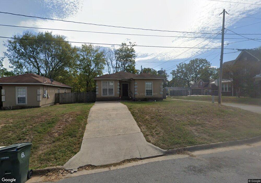
1121 W 35th St Little Rock, AR 72206
South End NeighborhoodEstimated Value: $133,000 - $171,000
4
Beds
2
Baths
1,282
Sq Ft
$115/Sq Ft
Est. Value
About This Home
This home is located at 1121 W 35th St, Little Rock, AR 72206 and is currently estimated at $147,806, approximately $115 per square foot. 1121 W 35th St is a home located in Pulaski County with nearby schools including Washington Magnet Elementary School, Dunbar Magnet Middle School, and Little Rock Southwest High School.
Ownership History
Date
Name
Owned For
Owner Type
Purchase Details
Closed on
Apr 6, 2016
Sold by
Secretary Of Housing & Urban Development
Bought by
Ar Jj Homes Llc
Current Estimated Value
Purchase Details
Closed on
Aug 11, 2015
Sold by
Jpmorgan Chase Bank National Association
Bought by
The Secretary Of Housing & Urban Develop
Purchase Details
Closed on
Aug 4, 2015
Sold by
Nunn Carol and Bank Of England
Bought by
Jpmorgan Chase Bank National Association
Purchase Details
Closed on
Jul 16, 2011
Sold by
Burns Construction Llc
Bought by
Burns Josiah and Burns Sharee
Purchase Details
Closed on
Jan 8, 2009
Sold by
Burns Construction Llc
Bought by
Nunn Carol
Home Financials for this Owner
Home Financials are based on the most recent Mortgage that was taken out on this home.
Original Mortgage
$100,671
Interest Rate
5.42%
Mortgage Type
FHA
Create a Home Valuation Report for This Property
The Home Valuation Report is an in-depth analysis detailing your home's value as well as a comparison with similar homes in the area
Home Values in the Area
Average Home Value in this Area
Purchase History
| Date | Buyer | Sale Price | Title Company |
|---|---|---|---|
| Ar Jj Homes Llc | -- | Lenders Title Company | |
| The Secretary Of Housing & Urban Develop | -- | Attorney | |
| Jpmorgan Chase Bank National Association | $83,577 | Attorney | |
| Burns Josiah | -- | None Available | |
| Nunn Carol | $102,000 | Clear Title Of Arkansas |
Source: Public Records
Mortgage History
| Date | Status | Borrower | Loan Amount |
|---|---|---|---|
| Previous Owner | Nunn Carol | $100,671 |
Source: Public Records
Tax History Compared to Growth
Tax History
| Year | Tax Paid | Tax Assessment Tax Assessment Total Assessment is a certain percentage of the fair market value that is determined by local assessors to be the total taxable value of land and additions on the property. | Land | Improvement |
|---|---|---|---|---|
| 2025 | $1,647 | $23,523 | $1,000 | $22,523 |
| 2024 | $1,422 | $23,523 | $1,000 | $22,523 |
| 2023 | $1,422 | $23,523 | $1,000 | $22,523 |
| 2022 | $1,303 | $23,523 | $1,000 | $22,523 |
| 2021 | $1,194 | $16,930 | $600 | $16,330 |
| 2020 | $1,185 | $16,930 | $600 | $16,330 |
| 2019 | $1,185 | $16,930 | $600 | $16,330 |
| 2018 | $1,185 | $16,930 | $600 | $16,330 |
| 2017 | $1,185 | $16,930 | $600 | $16,330 |
| 2016 | $1,243 | $17,750 | $2,200 | $15,550 |
| 2015 | $1,244 | $17,750 | $2,200 | $15,550 |
| 2014 | $1,244 | $17,750 | $2,200 | $15,550 |
Source: Public Records
Map
Nearby Homes
- 0 W 36th St
- 000 W 36th St
- 1118 W 35th St
- 1513 W 33rd St
- 3109 S Ringo St
- 2913 S Cross St
- 3010 S Izard St
- 3115 S State St
- 3119 S Gaines St
- 2811 S Chester St
- 2706 Doctor Martin Luther King Junior Dr
- 408 W 32nd St
- 3319 Short Spring St
- 2700 Doctor Martin Luther King Junior Dr
- 2415 S Chester St
- 2620 Bishop St
- 2607 S Cross St
- 2719 S Battery St
- 2815 Broadway St
- 2600 Wolfe St