Estimated Value: $1,037,000 - $1,173,749
8
Beds
4
Baths
5,734
Sq Ft
$194/Sq Ft
Est. Value
About This Home
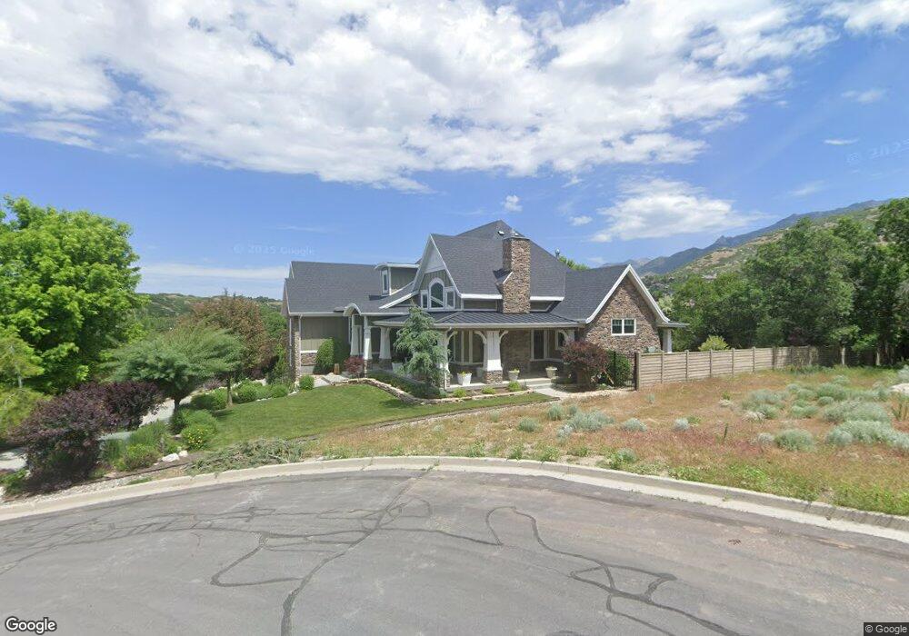
This home is located at 11218 S Tall Pines Way, Sandy, UT 84092 and is currently estimated at $1,111,687, approximately $193 per square foot. 11218 S Tall Pines Way is a home located in Salt Lake County with nearby schools including Sunrise Elementary School, Bell Canyon Montessori School, and Challenger School - Sandy.
Ownership History
Date
Name
Owned For
Owner Type
Purchase Details
Closed on
Mar 29, 2013
Sold by
Lasson Grant M
Bought by
Lasson Grant and Lasson Ramona
Current Estimated Value
Purchase Details
Closed on
Feb 29, 2000
Sold by
Burton James R and Burton Mary Jane
Bought by
Lasson Grant M
Purchase Details
Closed on
May 2, 1995
Sold by
Jordan Commons L C
Bought by
Burton James R and Burton Mary Jane
Home Financials for this Owner
Home Financials are based on the most recent Mortgage that was taken out on this home.
Original Mortgage
$296,000
Interest Rate
8.46%
Purchase Details
Closed on
Apr 24, 1995
Sold by
Robinson Mark H and Robinson Michael N
Bought by
Jordan Commons L C
Home Financials for this Owner
Home Financials are based on the most recent Mortgage that was taken out on this home.
Original Mortgage
$296,000
Interest Rate
8.46%
Purchase Details
Closed on
Feb 3, 1995
Sold by
Miller Rebecca B
Bought by
Jordan Commons L C
Purchase Details
Closed on
Jan 31, 1995
Sold by
Miller Rebecca B
Bought by
Robinson Mark H and Robinson Michael N
Create a Home Valuation Report for This Property
The Home Valuation Report is an in-depth analysis detailing your home's value as well as a comparison with similar homes in the area
Home Values in the Area
Average Home Value in this Area
Purchase History
| Date | Buyer | Sale Price | Title Company |
|---|---|---|---|
| Lasson Grant | -- | None Available | |
| Lasson Grant M | -- | Backman Stewart Title Servic | |
| Burton James R | -- | -- | |
| Jordan Commons L C | -- | -- | |
| Jordan Commons L C | -- | -- | |
| Robinson Mark H | -- | -- |
Source: Public Records
Mortgage History
| Date | Status | Borrower | Loan Amount |
|---|---|---|---|
| Previous Owner | Burton James R | $296,000 |
Source: Public Records
Tax History Compared to Growth
Tax History
| Year | Tax Paid | Tax Assessment Tax Assessment Total Assessment is a certain percentage of the fair market value that is determined by local assessors to be the total taxable value of land and additions on the property. | Land | Improvement |
|---|---|---|---|---|
| 2025 | $5,472 | $1,047,800 | $327,500 | $720,300 |
| 2024 | $5,472 | $1,012,000 | $315,300 | $696,700 |
| 2023 | $5,049 | $931,000 | $303,200 | $627,800 |
| 2022 | $5,260 | $947,500 | $297,300 | $650,200 |
| 2021 | $4,338 | $665,200 | $246,000 | $419,200 |
| 2020 | $4,588 | $663,400 | $246,000 | $417,400 |
| 2019 | $4,465 | $629,100 | $237,200 | $391,900 |
| 2018 | $4,221 | $619,200 | $237,200 | $382,000 |
| 2017 | $4,243 | $594,700 | $237,200 | $357,500 |
| 2016 | $4,026 | $545,500 | $213,700 | $331,800 |
| 2015 | $3,932 | $493,000 | $220,100 | $272,900 |
| 2014 | $3,921 | $481,900 | $220,100 | $261,800 |
Source: Public Records
Map
Nearby Homes
- 2022 Tall Pines Way
- 15 Lone Hollow Dr
- 2234 E Willow Brook Way
- 11458 Lexington Hills Dr
- 1937 Wasatch Blvd
- 5 Quietwood Ln
- 11065 Longdale Cir
- 98 E Lone Hollow Dr S Unit 902
- 2058 E Oak Manor Dr
- 2125 Dimple Dell Rd
- 10665 S 2340 E
- 10868 Prescott Dr
- 11415 S Hagan Rd
- 39 Northridge Way
- 1 Pepperwood Pointe
- 1 Cross Hill Ln
- 1612 E Hidden Valley Rd
- 11778 S 1700 E
- 11545 S Hagan Rd
- 89 Lone Hollow Dr Unit 1026
- 11218 Tall Pines Way
- 11204 Tall Pines Way
- 11234 S Tall Pines Way
- 11234 Tall Pines Way
- 2008 Wyngate Cir
- 2008 E Wyngate Cir
- 11188 Tall Pines Way
- 2021 Tall Pines Way
- 11188 S Tall Pines Way
- 11227 Tall Pines Way
- 2009 E Wyngate Cir
- 11213 S Tall Pines Way
- 2009 Wyngate Cir
- 11213 Tall Pines Way
- 2002 Wyngate Cir
- 11239 S Tall Pines Way
- 11201 Tall Pines Way
- 11239 Tall Pines Way
- 1999 Tall Pines Way
- 11187 S Tall Pines Way