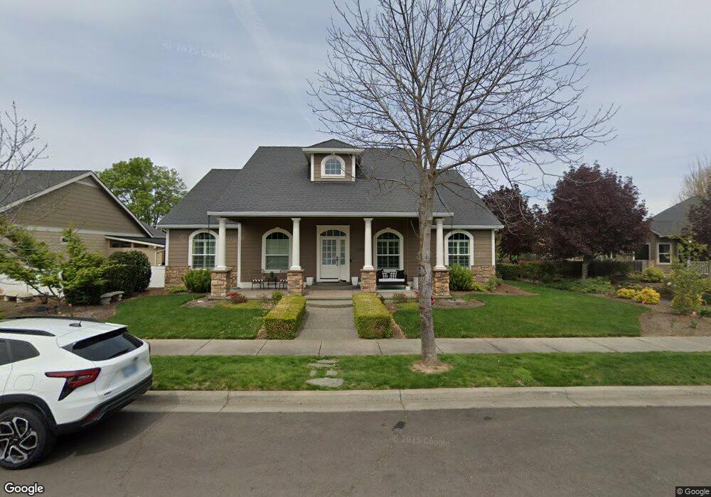
1122 Steamboat Dr Central Point, OR 97502
Estimated Value: $555,000 - $606,000
3
Beds
3
Baths
2,095
Sq Ft
$277/Sq Ft
Est. Value
About This Home
This home is located at 1122 Steamboat Dr, Central Point, OR 97502 and is currently estimated at $579,755, approximately $276 per square foot. 1122 Steamboat Dr is a home located in Jackson County with nearby schools including Richardson Elementary School, Scenic Middle School, and Crater High School.
Ownership History
Date
Name
Owned For
Owner Type
Purchase Details
Closed on
Dec 13, 2004
Sold by
Vision Homes Inc
Bought by
Bautista Victor C and Bautista Amber L
Current Estimated Value
Home Financials for this Owner
Home Financials are based on the most recent Mortgage that was taken out on this home.
Original Mortgage
$165,000
Outstanding Balance
$79,664
Interest Rate
5.5%
Mortgage Type
New Conventional
Estimated Equity
$500,091
Purchase Details
Closed on
Jun 25, 2004
Sold by
Twin Creeks Development Co Llc
Bought by
Vision Homes Inc
Create a Home Valuation Report for This Property
The Home Valuation Report is an in-depth analysis detailing your home's value as well as a comparison with similar homes in the area
Purchase History
| Date | Buyer | Sale Price | Title Company |
|---|---|---|---|
| Bautista Victor C | $288,539 | Amerititle | |
| Vision Homes Inc | $70,000 | Amerititle |
Source: Public Records
Mortgage History
| Date | Status | Borrower | Loan Amount |
|---|---|---|---|
| Open | Bautista Victor C | $165,000 |
Source: Public Records
Tax History
| Year | Tax Paid | Tax Assessment Tax Assessment Total Assessment is a certain percentage of the fair market value that is determined by local assessors to be the total taxable value of land and additions on the property. | Land | Improvement |
|---|---|---|---|---|
| 2026 | $5,290 | $319,650 | -- | -- |
| 2025 | $5,160 | $310,340 | $113,760 | $196,580 |
| 2024 | $5,160 | $301,310 | $110,450 | $190,860 |
| 2023 | $4,994 | $292,540 | $107,230 | $185,310 |
| 2022 | $4,877 | $292,540 | $107,230 | $185,310 |
| 2021 | $4,738 | $284,020 | $104,110 | $179,910 |
| 2020 | $4,600 | $275,750 | $101,080 | $174,670 |
| 2019 | $4,486 | $259,930 | $95,280 | $164,650 |
| 2018 | $4,349 | $252,360 | $92,510 | $159,850 |
| 2017 | $4,240 | $252,360 | $92,510 | $159,850 |
| 2016 | $4,116 | $237,880 | $87,200 | $150,680 |
| 2015 | $3,944 | $237,880 | $87,200 | $150,680 |
| 2014 | $3,844 | $224,240 | $82,200 | $142,040 |
Source: Public Records
Map
Nearby Homes
- 1134 Steamboat Dr
- 407 Silver Creek Dr
- 650 Golden Peak Dr
- 626 Griffin Oaks Dr
- 404 Silver Creek Dr
- 0 Boulder Ridge St
- 545 Bridge Creek Dr
- 1407 Rustler Peak St
- 420 Mayberry Ln
- 4626 N Pacific Hwy
- 884 Mendolia Way
- 356 Marian Ave Unit 40
- 166 Nadine Ln
- 342 Hazel St
- 55 Crater Ln
- 349 W Pine St
- 1860 Cottonwood Dr
- 1855 Nancy Ave
- 209 Corcoran Ln
- 348 N 6th St
- 1126 Steamboat Dr
- 1018 Steamboat Dr
- 1130 Steamboat Dr
- 1123 Shake Dr
- 1127 Shake Dr
- 1019 Shake Dr
- 1014 Steamboat Dr
- 1121 Steamboat Dr
- 1125 Steamboat Dr
- 1017 Steamboat Dr
- 1131 Shake Dr
- 1015 Shake Dr
- 1010 Steamboat Dr
- 1129 Steamboat Dr
- 1013 Steamboat Dr
- 1011 Shake Dr
- 801 Rustler Peak St
- 1124 Shake Dr
- 2380 Tulane Ave
- 919 Sandoz St
Your Personal Tour Guide
Ask me questions while you tour the home.