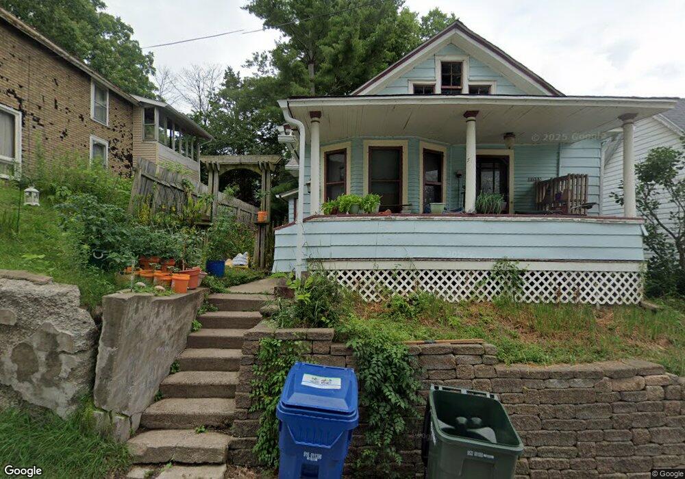
1123 Hildreth St Davenport, IA 52803
East End NeighborhoodEstimated Value: $86,000 - $155,000
2
Beds
1
Bath
854
Sq Ft
$129/Sq Ft
Est. Value
About This Home
This home is located at 1123 Hildreth St, Davenport, IA 52803 and is currently estimated at $110,333, approximately $129 per square foot. 1123 Hildreth St is a home located in Scott County with nearby schools including McKinley Elementary School, Casey County Middle School, and Sudlow Intermediate School.
Ownership History
Date
Name
Owned For
Owner Type
Purchase Details
Closed on
Jul 1, 2003
Sold by
Mcclain Mary and Wehner William W
Bought by
Aunt Rhodies Properties Llc
Current Estimated Value
Home Financials for this Owner
Home Financials are based on the most recent Mortgage that was taken out on this home.
Original Mortgage
$230,000
Interest Rate
6.5%
Mortgage Type
Purchase Money Mortgage
Create a Home Valuation Report for This Property
The Home Valuation Report is an in-depth analysis detailing your home's value as well as a comparison with similar homes in the area
Home Values in the Area
Average Home Value in this Area
Purchase History
| Date | Buyer | Sale Price | Title Company |
|---|---|---|---|
| Aunt Rhodies Properties Llc | $216,250 | None Available |
Source: Public Records
Mortgage History
| Date | Status | Borrower | Loan Amount |
|---|---|---|---|
| Previous Owner | Aunt Rhodies Properties Llc | $230,000 |
Source: Public Records
Tax History Compared to Growth
Tax History
| Year | Tax Paid | Tax Assessment Tax Assessment Total Assessment is a certain percentage of the fair market value that is determined by local assessors to be the total taxable value of land and additions on the property. | Land | Improvement |
|---|---|---|---|---|
| 2025 | $1,178 | $74,260 | $11,500 | $62,760 |
| 2024 | $1,150 | $65,890 | $11,500 | $54,390 |
| 2023 | $1,362 | $65,890 | $11,500 | $54,390 |
| 2022 | $1,283 | $54,370 | $6,900 | $47,470 |
| 2021 | $1,166 | $54,370 | $6,900 | $47,470 |
| 2020 | $1,390 | $52,310 | $6,900 | $45,410 |
| 2019 | $1,417 | $52,310 | $6,900 | $45,410 |
| 2018 | $456 | $52,310 | $6,900 | $45,410 |
| 2017 | $1,190 | $52,310 | $6,900 | $45,410 |
| 2016 | $1,359 | $52,310 | $0 | $0 |
| 2015 | $1,146 | $54,330 | $0 | $0 |
| 2014 | $1,206 | $54,330 | $0 | $0 |
| 2013 | $1,186 | $0 | $0 | $0 |
| 2012 | -- | $47,470 | $6,010 | $41,460 |
Source: Public Records
Map
Nearby Homes
- 1233 Eastern Ave
- 1202 Adams St
- 1504 Christie St
- 1325 Mississippi Ave
- 2316 East St
- 1515 Jersey Ridge Rd
- 1102 College Ave
- 1220 College Ave
- 1704 Jersey Ridge Rd
- 1803 Belle Ave
- 1004 College Ave
- 1224 E 11th St
- 1815 Belle Ave
- 1310 Kirkwood Blvd
- 1616 Esplanade Ave
- 1626 Esplanade Ave
- 1012 Bridge Ave
- 1734 Ridgewood Ave
- 2316 E Pleasant St
- 1 Kenwood Ave
- 1121 Hildreth St
- 2003 E 12th St
- 2013 E 12th St
- 1120 Hildreth St
- 1929 E 12th St
- 2019 E 12th St
- 2006 E 11th St
- 2002 E 11th St
- 1930 E 11th St
- 2012 E 11th St
- 1928 E 11th St
- 1919 E 12th St
- 2004 E 12th St
- 2008 E 12th St
- 2010 E 12th St
- 2014 E 12th St
- 1128 Mound St
- 1922 E 12th St
- 1114 Mound St
- 1114 Mound St Unit B