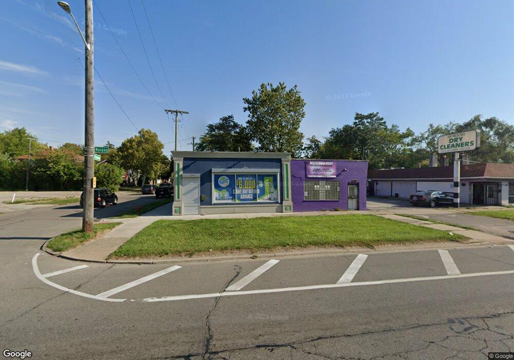
11244 Morang Dr Detroit, MI 48224
Moross-Morang NeighborhoodEstimated Value: $77,061
--
Bed
--
Bath
2,019
Sq Ft
$38/Sq Ft
Est. Value
About This Home
This home is located at 11244 Morang Dr, Detroit, MI 48224 and is currently estimated at $77,061, approximately $38 per square foot. 11244 Morang Dr is a home located in Wayne County with nearby schools including Carleton Elementary School, Edward 'Duke' Ellington Conservatory of Music and Art, and Charles L. Spain Elementary-Middle School.
Ownership History
Date
Name
Owned For
Owner Type
Purchase Details
Closed on
Jan 23, 2023
Sold by
City Management Group Inc
Bought by
Sys Investment Groups Llc
Current Estimated Value
Purchase Details
Closed on
Apr 4, 2017
Sold by
K C Rose & Associates Enterprises Llc
Bought by
City Management Group
Purchase Details
Closed on
Jun 3, 2011
Sold by
Advanced Property Investments Llc
Bought by
K C Rose & Associates Enterprises Llc
Purchase Details
Closed on
Mar 16, 2007
Sold by
Yates Gordon and Yates Paulette
Bought by
Advanced Property Investments
Create a Home Valuation Report for This Property
The Home Valuation Report is an in-depth analysis detailing your home's value as well as a comparison with similar homes in the area
Home Values in the Area
Average Home Value in this Area
Purchase History
| Date | Buyer | Sale Price | Title Company |
|---|---|---|---|
| Sys Investment Groups Llc | $65,000 | Visionary Title Agency | |
| City Management Group Inc | -- | Visionary Title Agency | |
| City Management Group | -- | None Available | |
| K C Rose & Associates Enterprises Llc | -- | None Available | |
| Advanced Property Investments | $34,500 | Multiple |
Source: Public Records
Tax History Compared to Growth
Tax History
| Year | Tax Paid | Tax Assessment Tax Assessment Total Assessment is a certain percentage of the fair market value that is determined by local assessors to be the total taxable value of land and additions on the property. | Land | Improvement |
|---|---|---|---|---|
| 2025 | $3,420 | $42,300 | $0 | $0 |
| 2024 | $3,420 | $38,100 | $0 | $0 |
| 2023 | $2,211 | $41,300 | $0 | $0 |
| 2022 | $3,004 | $36,500 | $0 | $0 |
| 2021 | $2,887 | $30,900 | $0 | $0 |
| 2020 | $2,817 | $31,600 | $0 | $0 |
| 2019 | $2,266 | $26,500 | $0 | $0 |
| 2018 | $1,940 | $25,100 | $0 | $0 |
| 2017 | $1,414 | $23,500 | $0 | $0 |
| 2016 | $2,513 | $23,200 | $0 | $0 |
| 2015 | $2,320 | $23,200 | $0 | $0 |
| 2013 | $2,318 | $23,180 | $0 | $0 |
| 2010 | -- | $24,964 | $2,499 | $22,465 |
Source: Public Records
Map
Nearby Homes
- 11106 Nottingham Rd
- 11317 Somerset Ave
- 11210 Beaconsfield St
- 11510 Nottingham Rd
- 11201 Beaconsfield St
- 10878 Balfour Rd
- 11333 Balfour Rd
- 11090 Mckinney St
- 10827 Balfour Rd
- 11552 Nottingham Rd
- 10825 Worden St
- 11609 Beaconsfield St
- 11514 Morang Dr
- 11466 Somerset Ave
- 10830 Mckinney St
- 10799 Worden St
- 11635 Beaconsfield St
- 10728 Worden St
- 11375 Roxbury St
- 11490 Somerset Ave
- 11230 Morang Dr
- 11334 Nottingham Rd
- 11222 Morang Dr
- 11214 Morang Dr
- 11336 Nottingham Rd
- 11210 Morang Ave Unit 1
- 11237 Somerset Ave
- 11344 Nottingham Rd
- 11329 Nottingham Rd
- 11210 Morang Dr Unit 1
- 11210 Morang Dr
- 11229 Somerset Ave
- 11213 Morang Dr
- 11352 Nottingham Rd
- 11233 Morang Dr
- 11253 Somerset Ave
- 11337 Nottingham Rd
- 11245 Somerset Ave
- 11345 Nottingham Rd
- 11261 Somerset Ave