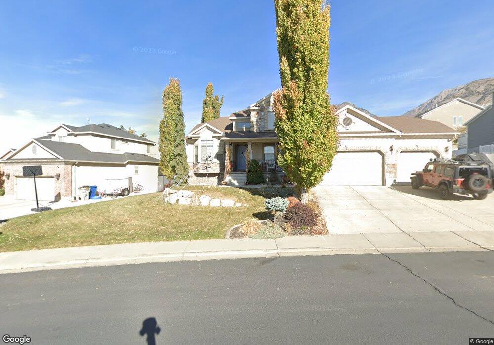
1127 E 400 S Pleasant Grove, UT 84062
Estimated Value: $713,000 - $756,000
5
Beds
4
Baths
3,562
Sq Ft
$204/Sq Ft
Est. Value
About This Home
This home is located at 1127 E 400 S, Pleasant Grove, UT 84062 and is currently estimated at $728,174, approximately $204 per square foot. 1127 E 400 S is a home located in Utah County with nearby schools including Valley View Elementary, Central Elementary School, and Oak Canyon Junior High School.
Ownership History
Date
Name
Owned For
Owner Type
Purchase Details
Closed on
Mar 8, 2017
Sold by
Hardman Ken and Hardman Joan
Bought by
Leishman Michael R and Leishman Lisa Christine
Current Estimated Value
Home Financials for this Owner
Home Financials are based on the most recent Mortgage that was taken out on this home.
Original Mortgage
$269,600
Outstanding Balance
$137,715
Interest Rate
4.19%
Mortgage Type
New Conventional
Estimated Equity
$590,459
Purchase Details
Closed on
Jul 21, 2003
Sold by
Ivory Homes Ltd
Bought by
Hardman Ken and Hardman Joan
Home Financials for this Owner
Home Financials are based on the most recent Mortgage that was taken out on this home.
Original Mortgage
$236,454
Interest Rate
5.15%
Mortgage Type
Purchase Money Mortgage
Purchase Details
Closed on
Jan 16, 2003
Sold by
H & M Properties Lc
Bought by
Ivory Homes Ltd
Create a Home Valuation Report for This Property
The Home Valuation Report is an in-depth analysis detailing your home's value as well as a comparison with similar homes in the area
Home Values in the Area
Average Home Value in this Area
Purchase History
| Date | Buyer | Sale Price | Title Company |
|---|---|---|---|
| Leishman Michael R | -- | Bay National Title Co | |
| Hardman Ken | -- | Cottonwood Title | |
| Ivory Homes Ltd | -- | Cottonwood Title |
Source: Public Records
Mortgage History
| Date | Status | Borrower | Loan Amount |
|---|---|---|---|
| Open | Leishman Michael R | $269,600 | |
| Previous Owner | Hardman Ken | $236,454 |
Source: Public Records
Tax History Compared to Growth
Tax History
| Year | Tax Paid | Tax Assessment Tax Assessment Total Assessment is a certain percentage of the fair market value that is determined by local assessors to be the total taxable value of land and additions on the property. | Land | Improvement |
|---|---|---|---|---|
| 2025 | $2,994 | $374,605 | $233,500 | $447,600 |
| 2024 | $2,869 | $349,360 | $0 | $0 |
| 2023 | $2,869 | $350,570 | $0 | $0 |
| 2022 | $2,929 | $356,125 | $0 | $0 |
| 2021 | $2,562 | $474,300 | $146,600 | $327,700 |
| 2020 | $2,348 | $426,100 | $130,900 | $295,200 |
| 2019 | $2,232 | $418,800 | $123,600 | $295,200 |
| 2018 | $2,102 | $373,000 | $116,300 | $256,700 |
| 2017 | $2,087 | $197,175 | $0 | $0 |
| 2016 | $2,010 | $183,315 | $0 | $0 |
| 2015 | $2,050 | $177,045 | $0 | $0 |
| 2014 | $1,857 | $158,895 | $0 | $0 |
Source: Public Records
Map
Nearby Homes
- 286 S 1150 E
- 177 S 1150 E
- Prelude Plan at Blossom Hill
- Treble Plan at Blossom Hill
- Browning Plan at Blossom Hill
- Cantata Plan at Blossom Hill
- 176 S 1150 E
- Accord Plan at Blossom Hill
- Canon Plan at Blossom Hill
- Trio Plan at Blossom Hill
- Harrison Plan at Blossom Hill
- Adagio Plan at Blossom Hill
- Tempo Plan at Blossom Hill
- Ballad Plan at Blossom Hill
- Timpani Plan at Blossom Hill
- Octave Plan at Blossom Hill
- Interlude Plan at Blossom Hill
- Crescendo Plan at Blossom Hill
- Finale Plan at Blossom Hill
- Forte Plan at Blossom Hill
- 1141 E 400 S
- 384 S Murdock Dr
- 404 S Murdock Dr
- 364 S Murdock Dr
- 1142 E 400 S
- 419 S Murdock Dr
- 386 S 1150 E
- 275 S Murdock Dr
- 352 S 1150 E
- 422 S Murdock Dr
- 1146 E 400 S
- 328 S 1150 E
- 442 S Murdock Dr
- 1152 E 400 S
- 453 S Murdock Dr
- 375 S Murdock Dr
- 397 S 1150 E
- 302 S 1150 E Unit 23
- 1162 E 320 S
- 458 S Murdock Dr