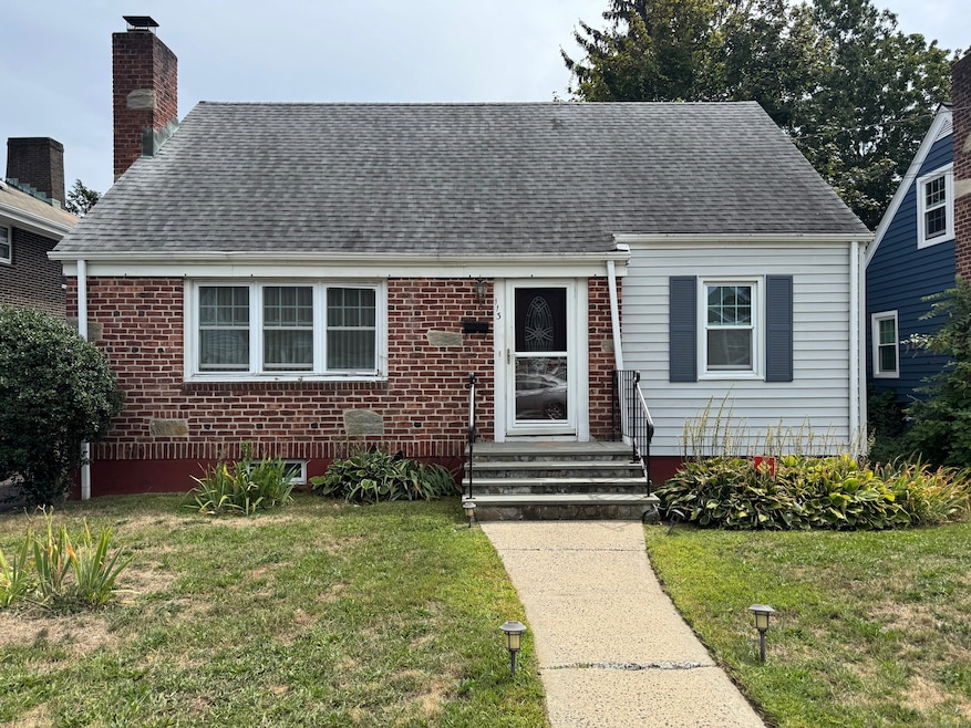
113 Clark St Bridgeport, CT 06606
North End NeighborhoodEstimated payment $2,773/month
Highlights
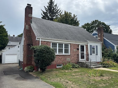
- Cape Cod Architecture
- Property is near shops
- Hot Water Heating System
- 1 Fireplace
- Hot Water Circulator
- Level Lot
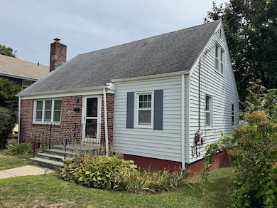
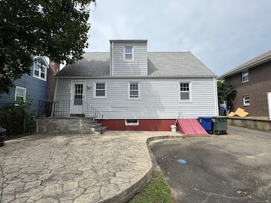
About This Home
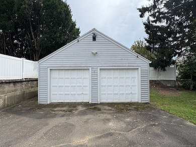
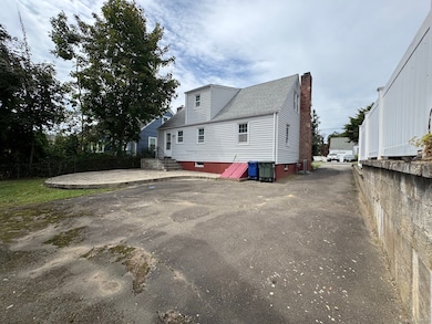
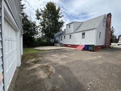
*INCREDIBLE PRICE* Charming Turn-Key North End Cape - Convenient Location! Welcome to this beautifully maintained Cape-style home in Bridgeport's desirable North End. Offering 3 bedrooms, 1 full & 1 half baths, this sun-filled home features a comfortable living room with fireplace & picture window, spacious kitchen opens to family/dining area with access to a large patio, and gleaming hardwood floors throughout. The lovely backyard is perfect for relaxing or entertaining, and the detached 2-car garage provides added convenience. Full basement for storage. Ideally located just minutes from major highways (Merritt Parkway & I-95), Metro-North train stations, and the Bridgeport-Port Jefferson Ferry, commuting is a breeze. Enjoy nearby parks, schools, shopping, and dining-all within easy reach. A perfect blend of charm, comfort, and accessibility makes this home an excellent choice!
Listing Agent
Silver Pine Real Estate Brokerage Phone: (203) 600-5335 License #RES.0818937 Listed on: 08/19/2025
Home Details
Home Type
- Single Family
Est. Annual Taxes
- $7,366
Year Built
- Built in 1950
Lot Details
- 4,792 Sq Ft Lot
- Level Lot
- Property is zoned RA
Parking
- 2 Car Garage
Home Design
- Cape Cod Architecture
- Concrete Foundation
- Frame Construction
- Asphalt Shingled Roof
- Vinyl Siding
Interior Spaces
- 1,309 Sq Ft Home
- 1 Fireplace
- Unfinished Basement
- Basement Fills Entire Space Under The House
- Gas Range
Bedrooms and Bathrooms
- 3 Bedrooms
Location
- Property is near shops
Utilities
- Hot Water Heating System
- Heating System Uses Natural Gas
- Hot Water Circulator
Listing and Financial Details
- Assessor Parcel Number 35401
Map
Home Values in the Area
Average Home Value in this Area
Tax History
| Year | Tax Paid | Tax Assessment Tax Assessment Total Assessment is a certain percentage of the fair market value that is determined by local assessors to be the total taxable value of land and additions on the property. | Land | Improvement |
|---|---|---|---|---|
| 2025 | $7,366 | $169,520 | $75,310 | $94,210 |
| 2024 | $7,366 | $169,520 | $75,310 | $94,210 |
| 2023 | $7,366 | $169,520 | $75,310 | $94,210 |
| 2022 | $7,366 | $169,520 | $75,310 | $94,210 |
| 2021 | $7,366 | $169,520 | $75,310 | $94,210 |
| 2020 | $6,304 | $116,760 | $41,310 | $75,450 |
| 2019 | $6,304 | $116,760 | $41,310 | $75,450 |
| 2018 | $6,348 | $116,760 | $41,310 | $75,450 |
| 2017 | $6,348 | $116,760 | $41,310 | $75,450 |
| 2016 | $6,348 | $116,760 | $41,310 | $75,450 |
| 2015 | $5,721 | $135,570 | $49,980 | $85,590 |
| 2014 | $5,721 | $135,570 | $49,980 | $85,590 |
Property History
| Date | Event | Price | List to Sale | Price per Sq Ft |
|---|---|---|---|---|
| 09/30/2025 09/30/25 | Price Changed | $410,000 | -2.4% | $313 / Sq Ft |
| 09/01/2025 09/01/25 | For Sale | $420,000 | -- | $321 / Sq Ft |
Purchase History
| Date | Type | Sale Price | Title Company |
|---|---|---|---|
| Quit Claim Deed | -- | -- | |
| Quit Claim Deed | -- | -- | |
| Warranty Deed | $136,500 | -- | |
| Warranty Deed | $136,500 | -- | |
| Foreclosure Deed | -- | -- | |
| Foreclosure Deed | -- | -- | |
| Executors Deed | $142,000 | -- | |
| Executors Deed | $142,000 | -- |
Mortgage History
| Date | Status | Loan Amount | Loan Type |
|---|---|---|---|
| Previous Owner | $134,027 | No Value Available |
Source: SmartMLS
MLS Number: 24120503
APN: BRID-002371-000020
Disclaimer: Certain information contained herein is derived from information provided by parties other than Homes.com. All information provided is deemed reliable, but is not guaranteed to be accurate and should be independently verified.
![]() IDX information is provided exclusively for personal, non-commercial use, and may not be used for any purpose other than to identify prospective properties consumers may be interested in purchasing. Information is deemed reliable but not guaranteed.
IDX information is provided exclusively for personal, non-commercial use, and may not be used for any purpose other than to identify prospective properties consumers may be interested in purchasing. Information is deemed reliable but not guaranteed.
- 260 Birmingham St
- 3401 Main St
- 214 Burnsford Ave
- 184 Merritt St
- 354 Beechmont Ave
- 234 Savoy St
- 376 Savoy St
- 1095 Wayne St
- 45 Stevens St Unit 2
- 339 Goldenrod Ave
- 5 Stevens St
- 604 Birmingham St
- 375 Ruth St
- 1265 Lindley St
- 520 Savoy St
- 25 Broadway
- 485 Westfield Ave
- 631 Fairview Ave
- 355 Exeter St
- 213 Exeter St
- 925 Wayne St Unit 1
- 448 Exeter St Unit 2
- 415 Clark St
- 642 Beechmont Ave
- 466 Merritt St
- 452 Summit St Unit 2
- 405 Ruth St
- 208-210-210 Fairview Ave Unit 2
- 208 Fairview Ave Unit 2
- 174 Fairview Ave Unit 1
- 505 Jewett Ave
- 15 Overland Ave
- 87 Manhattan Ave Unit 3rd floor
- 105 Manhattan Ave
- 200 Woodmont Ave Unit 123
- 90 Amsterdam Ave Unit 1
- 90 Amsterdam Ave Unit 2
- 993 Lindley St Unit 1
- 680 Queen St
- 409 Woodmont Ave Unit 409
