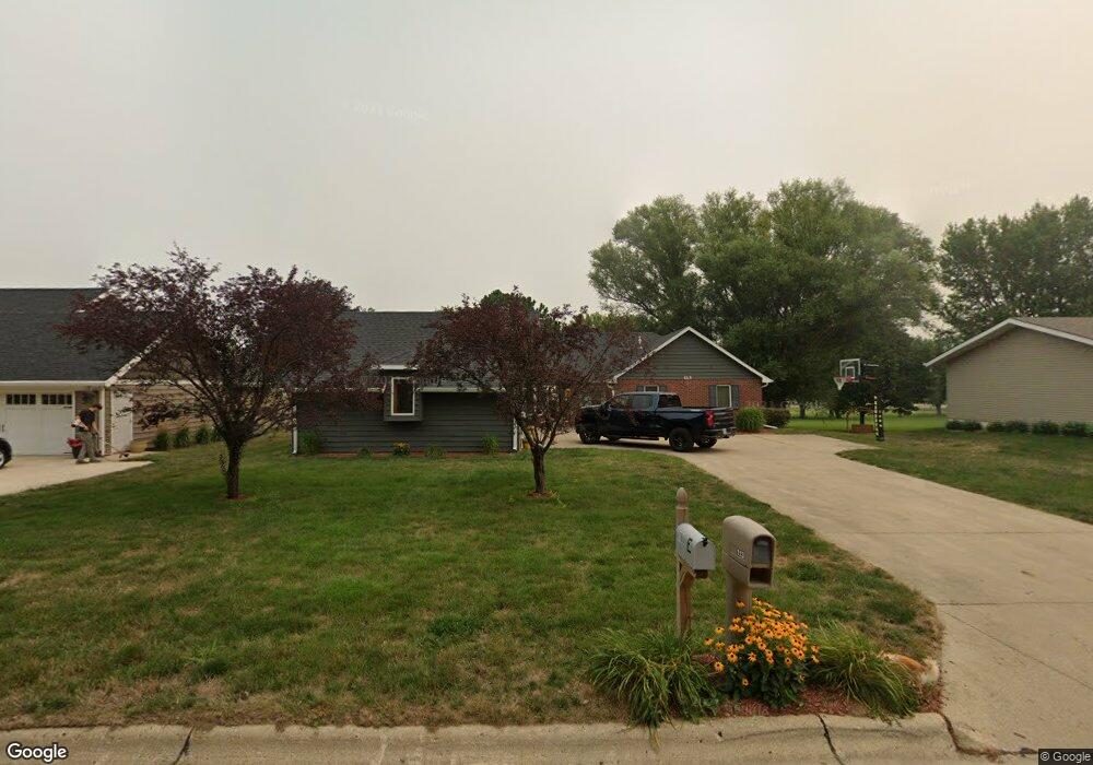
113 E Randall Rd Carroll, IA 51401
Estimated Value: $242,000 - $274,000
2
Beds
2
Baths
1,650
Sq Ft
$157/Sq Ft
Est. Value
About This Home
This home is located at 113 E Randall Rd, Carroll, IA 51401 and is currently estimated at $259,721, approximately $157 per square foot. 113 E Randall Rd is a home located in Carroll County with nearby schools including Fairview Elementary School, Adams Elementary School, and Carroll Middle School.
Ownership History
Date
Name
Owned For
Owner Type
Purchase Details
Closed on
Jul 18, 2012
Sold by
Rauch Billy D and Rauch Mari K
Bought by
Nieland Joleen H
Current Estimated Value
Purchase Details
Closed on
Jul 20, 2010
Sold by
Nees Elmer H and Nees Marjean D
Bought by
Meyer Mark R and Meyer Sherry A
Home Financials for this Owner
Home Financials are based on the most recent Mortgage that was taken out on this home.
Original Mortgage
$161,000
Interest Rate
4.5%
Mortgage Type
Adjustable Rate Mortgage/ARM
Create a Home Valuation Report for This Property
The Home Valuation Report is an in-depth analysis detailing your home's value as well as a comparison with similar homes in the area
Home Values in the Area
Average Home Value in this Area
Purchase History
| Date | Buyer | Sale Price | Title Company |
|---|---|---|---|
| Nieland Joleen H | $125,000 | None Available | |
| Meyer Mark R | $160,000 | Security Title & Investment |
Source: Public Records
Mortgage History
| Date | Status | Borrower | Loan Amount |
|---|---|---|---|
| Previous Owner | Meyer Mark R | $161,000 |
Source: Public Records
Tax History Compared to Growth
Tax History
| Year | Tax Paid | Tax Assessment Tax Assessment Total Assessment is a certain percentage of the fair market value that is determined by local assessors to be the total taxable value of land and additions on the property. | Land | Improvement |
|---|---|---|---|---|
| 2025 | $2,766 | $244,790 | $45,940 | $198,850 |
| 2024 | $2,708 | $221,160 | $45,940 | $175,220 |
| 2023 | $3,119 | $221,160 | $45,940 | $175,220 |
| 2022 | $2,958 | $213,020 | $41,760 | $171,260 |
| 2021 | $2,958 | $213,020 | $41,760 | $171,260 |
| 2020 | $3,030 | $213,020 | $41,760 | $171,260 |
| 2019 | $3,094 | $213,020 | $41,760 | $171,260 |
| 2018 | $2,910 | $213,020 | $41,760 | $171,260 |
| 2017 | $2,904 | $211,935 | $44,683 | $167,252 |
| 2016 | $2,710 | $198,070 | $0 | $0 |
| 2015 | $2,710 | $173,950 | $0 | $0 |
| 2014 | $2,338 | $173,950 | $0 | $0 |
Source: Public Records
Map
Nearby Homes
- 219 Windwood Dr
- 265 Perch St
- 2340 Skyline Dr
- 746 Granada Rd
- 1601 N Main St
- 1546 Olive St
- 1515 N Main St
- 260 Bass St
- 611 W 21st St
- 1509 Birch St
- 1852 Quint Ave
- 711 W 21st St
- 1320 N Adams St
- 638 Capistrano Ave
- 1550 Edgewood Dr
- 631 W 17th St
- 621 Alta Vista Dr
- 641 Alta Vista Dr
- 1810 Crestview Dr
- 1608 Salinger Ave
- 105 E Randall Rd
- 110 E Randall Rd
- 127 E Randall Rd
- 205 E Randall Rd
- 104 W Randall Rd
- 132 E Randall Rd
- 111 Lois Ave
- 2117 N Main St
- 121 Lois Ave
- 110 W Randall Rd
- 213 E Randall Rd
- 113 W Randall Rd
- 2105 N Main St
- 120 W Randall Rd
- 129 Lois Ave
- 135 Lois Ave
- 123 W Randall Rd
- 112 W 21st St
- 118 Lois Ave
- 2050 N Main St