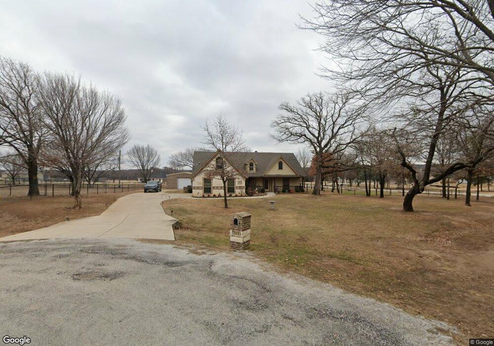
113 Knight Ct Springtown, TX 76082
Estimated Value: $352,000 - $413,000
3
Beds
2
Baths
1,786
Sq Ft
$215/Sq Ft
Est. Value
About This Home
This home is located at 113 Knight Ct, Springtown, TX 76082 and is currently estimated at $384,320, approximately $215 per square foot. 113 Knight Ct is a home located in Parker County with nearby schools including Springtown Elementary School, Springtown Intermediate School, and Springtown Middle School.
Ownership History
Date
Name
Owned For
Owner Type
Purchase Details
Closed on
Aug 2, 2011
Sold by
Amo La Vita At Wellington Ltd
Bought by
Tio Homes Llc
Current Estimated Value
Purchase Details
Closed on
Jul 27, 2010
Sold by
Amo La Vita At Wellington Ltd
Bought by
Bland Vernon S and Ashworth Jill A
Home Financials for this Owner
Home Financials are based on the most recent Mortgage that was taken out on this home.
Original Mortgage
$103,000
Interest Rate
4.76%
Mortgage Type
Purchase Money Mortgage
Purchase Details
Closed on
Mar 1, 2010
Sold by
First National Bank Of Granbury
Bought by
Bland Vernon S and Ashworth Jill A
Purchase Details
Closed on
May 8, 2008
Sold by
Compass Bank
Bought by
Bland Vernon S and Ashworth Jill A
Purchase Details
Closed on
Mar 13, 2008
Sold by
Vsi Properties Inc
Bought by
Bland Vernon S and Ashworth Jill A
Purchase Details
Closed on
Jan 18, 2006
Bought by
Bland Vernon S and Ashworth Jill A
Create a Home Valuation Report for This Property
The Home Valuation Report is an in-depth analysis detailing your home's value as well as a comparison with similar homes in the area
Home Values in the Area
Average Home Value in this Area
Purchase History
| Date | Buyer | Sale Price | Title Company |
|---|---|---|---|
| Tio Homes Llc | -- | Fnt | |
| Bland Vernon S | -- | Fnt | |
| Bland Vernon S | -- | -- | |
| Bland Vernon S | -- | -- | |
| Bland Vernon S | -- | -- | |
| Bland Vernon S | -- | -- |
Source: Public Records
Mortgage History
| Date | Status | Borrower | Loan Amount |
|---|---|---|---|
| Previous Owner | Bland Vernon S | $103,000 |
Source: Public Records
Tax History Compared to Growth
Tax History
| Year | Tax Paid | Tax Assessment Tax Assessment Total Assessment is a certain percentage of the fair market value that is determined by local assessors to be the total taxable value of land and additions on the property. | Land | Improvement |
|---|---|---|---|---|
| 2025 | $2,388 | $344,200 | $50,000 | $294,200 |
| 2024 | $2,388 | $326,964 | -- | -- |
| 2023 | $2,388 | $297,240 | $0 | $0 |
| 2022 | $3,843 | $270,220 | $50,000 | $220,220 |
| 2021 | $4,905 | $270,220 | $50,000 | $220,220 |
| 2020 | $4,445 | $230,370 | $40,000 | $190,370 |
| 2019 | $4,738 | $230,370 | $40,000 | $190,370 |
| 2018 | $4,321 | $207,720 | $30,000 | $177,720 |
| 2017 | $4,445 | $207,720 | $30,000 | $177,720 |
| 2016 | $4,041 | $185,390 | $25,000 | $160,390 |
| 2015 | $3,627 | $185,390 | $25,000 | $160,390 |
| 2014 | $3,785 | $184,080 | $29,000 | $155,080 |
Source: Public Records
Map
Nearby Homes
- 129 Cooper Ct
- 1009 Northern Oaks Ct
- 1035 Northern Oaks Ct
- 420 Sessums Rd
- 202 Morrow Rd
- 548 Highland Rd
- 510 Highland Rd
- 550 New Highland Rd
- 108 Howard Newby Ln
- 108 Milton Dr
- 144 Howard Newby Ln
- 116 E Highway 199
- 3523 E Highway 199
- 301 Jonny Boy Way
- 317 Jonny Boy Way
- 320 English Ct
- TBD English Ct
- 321 Jonny Boy Way
- 114 Altom Rd
- 320 Jonny Boy Way