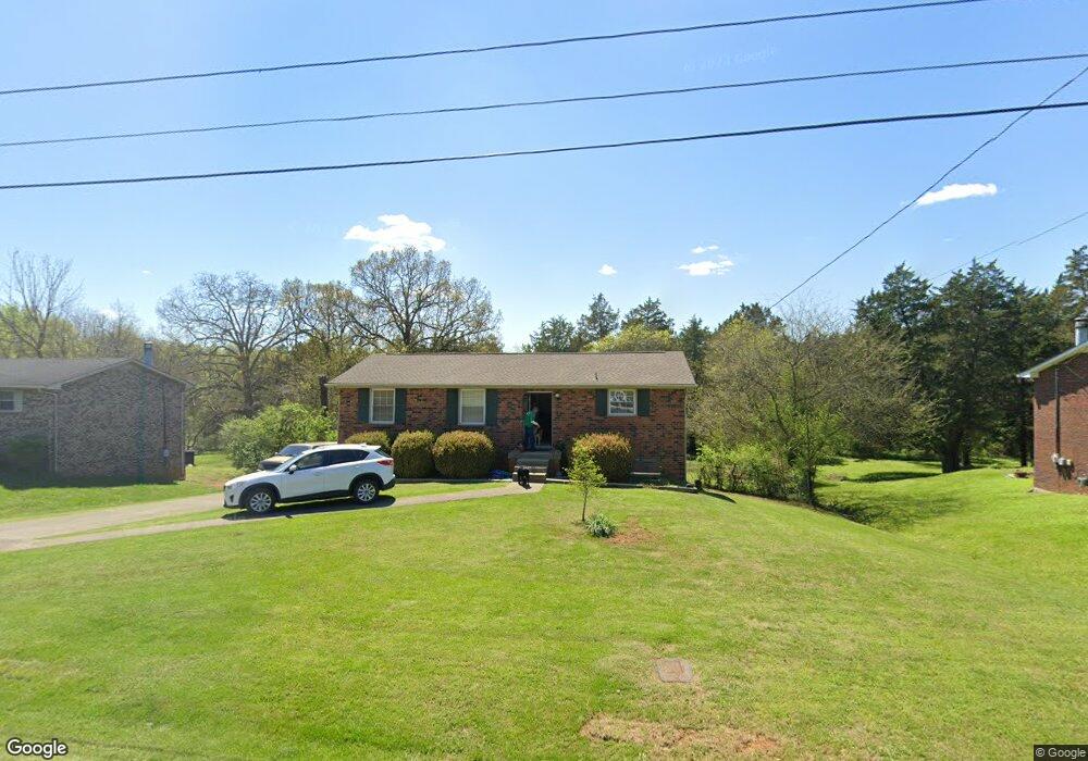
113 Long Rifle Rd Smyrna, TN 37167
Estimated Value: $294,230 - $353,000
--
Bed
2
Baths
1,125
Sq Ft
$287/Sq Ft
Est. Value
About This Home
This home is located at 113 Long Rifle Rd, Smyrna, TN 37167 and is currently estimated at $322,808, approximately $286 per square foot. 113 Long Rifle Rd is a home located in Rutherford County with nearby schools including Stewartsboro Elementary School, Rocky Fork Middle School, and Smyrna High School.
Ownership History
Date
Name
Owned For
Owner Type
Purchase Details
Closed on
Oct 2, 2025
Sold by
Music City Holdings Llc
Bought by
Bailey Matthew
Current Estimated Value
Purchase Details
Closed on
Nov 2, 1999
Sold by
Bank Of New York
Bought by
Deyampert Dwight A and Deyampert Desir
Purchase Details
Closed on
Jun 21, 1999
Sold by
Charles Brooks Jeffrey
Bought by
Bank Of New York
Create a Home Valuation Report for This Property
The Home Valuation Report is an in-depth analysis detailing your home's value as well as a comparison with similar homes in the area
Home Values in the Area
Average Home Value in this Area
Purchase History
| Date | Buyer | Sale Price | Title Company |
|---|---|---|---|
| Bailey Matthew | $275,500 | None Listed On Document | |
| Music City Holdings Llc | $250,000 | Spartan Title | |
| Deyampert Dwight A | $105,500 | -- | |
| Bank Of New York | $59,500 | -- |
Source: Public Records
Tax History Compared to Growth
Tax History
| Year | Tax Paid | Tax Assessment Tax Assessment Total Assessment is a certain percentage of the fair market value that is determined by local assessors to be the total taxable value of land and additions on the property. | Land | Improvement |
|---|---|---|---|---|
| 2025 | $1,607 | $66,900 | $13,750 | $53,150 |
| 2024 | $1,607 | $66,900 | $13,750 | $53,150 |
| 2023 | $1,607 | $66,900 | $13,750 | $53,150 |
| 2022 | $1,433 | $66,900 | $13,750 | $53,150 |
| 2021 | $1,259 | $43,100 | $7,750 | $35,350 |
| 2020 | $1,259 | $43,100 | $7,750 | $35,350 |
| 2019 | $1,259 | $43,100 | $7,750 | $35,350 |
| 2018 | $1,207 | $43,100 | $0 | $0 |
| 2017 | $1,084 | $30,400 | $0 | $0 |
| 2016 | $1,084 | $30,400 | $0 | $0 |
| 2015 | $1,084 | $30,400 | $0 | $0 |
| 2014 | $756 | $30,400 | $0 | $0 |
| 2013 | -- | $31,300 | $0 | $0 |
Source: Public Records
Map
Nearby Homes
- 308 Custer Ct
- 203 Longfellow Ln
- 109 Longfellow Ln
- 101 Longfellow Ln
- 121 Crockett Ct
- 1026 Rosemont Terrace
- 340 Stewarts Landing Cir
- 1014 Rosemont Terrace
- 211 Stewarts Landing Cir
- 213 Stewarts Landing Cir
- 104 Evanmeade Dr
- 2110 Alteras Dr
- 1023 Avery Park Dr
- 0 Old Nashville Hwy Unit RTC2943706
- 335 Longhorn Dr
- 321 Longhorn Dr
- 320 Longhorn Dr
- 374 Longhorn Dr
- 304 Belgian Ln
- 303 Davis Park Dr
- 111 Long Rifle Rd
- 115 Long Rifle Rd
- 117 Long Rifle Rd
- 109 Long Rifle Rd
- 400 Pony Dr
- 312 Custer Ct
- 110 Long Rifle Rd
- 107 Long Rifle Rd
- 119 Long Rifle Rd
- 112 Long Rifle Rd
- 402 Pony Dr
- 104 Long Rifle Rd
- 105 Long Rifle Rd
- 401 Pony Dr
- 310 Custer Ct
- 121 Long Rifle Rd
- 302 Custer Ct
- 114 Long Rifle Rd
- 404 Pony Dr
- 103 Long Rifle Rd