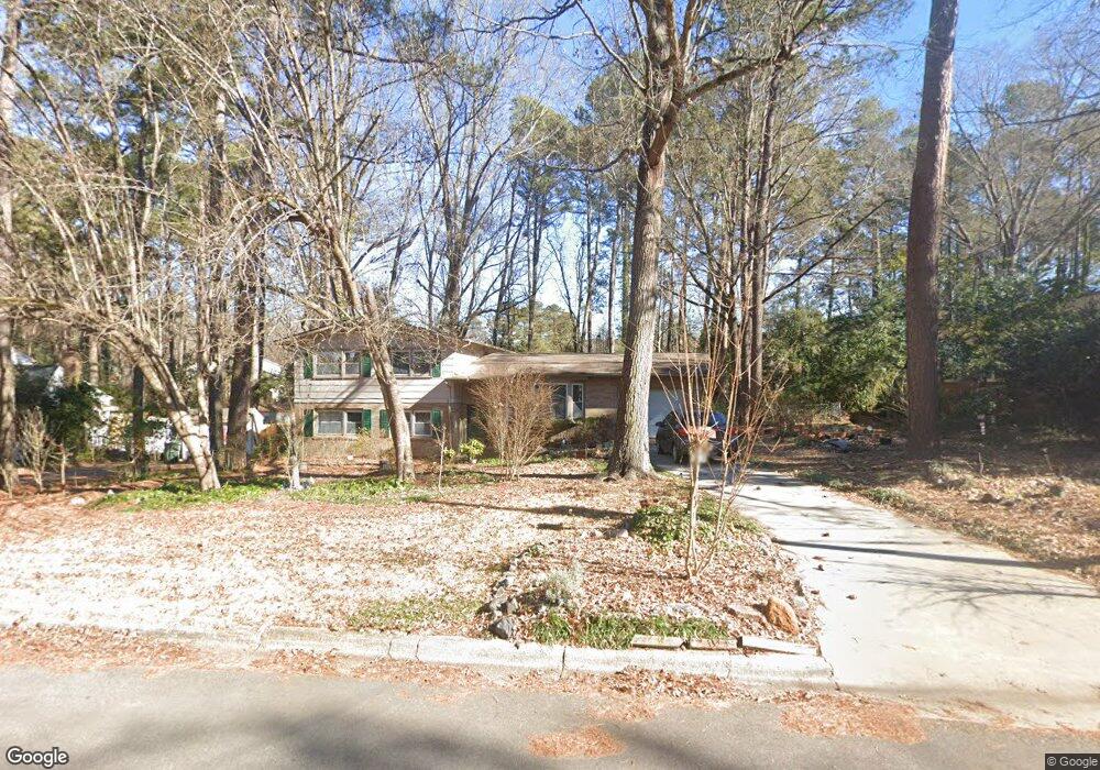
113 Montclair Cir Durham, NC 27713
South Durham NeighborhoodEstimated Value: $316,000 - $400,184
4
Beds
3
Baths
2,156
Sq Ft
$170/Sq Ft
Est. Value
About This Home
This home is located at 113 Montclair Cir, Durham, NC 27713 and is currently estimated at $367,546, approximately $170 per square foot. 113 Montclair Cir is a home located in Durham County with nearby schools including Parkwood Elementary, Lowe's Grove Middle, and Hillside High School.
Ownership History
Date
Name
Owned For
Owner Type
Purchase Details
Closed on
Jun 17, 2013
Sold by
Dlouhy Thomas L
Bought by
Connor Nancy T and Dlouhy Nancy T
Current Estimated Value
Home Financials for this Owner
Home Financials are based on the most recent Mortgage that was taken out on this home.
Original Mortgage
$103,000
Outstanding Balance
$73,039
Interest Rate
3.42%
Mortgage Type
New Conventional
Estimated Equity
$294,507
Purchase Details
Closed on
Apr 15, 1999
Sold by
Byrd Lewis G and Byrd Wife S
Bought by
Dlouhy Thomas L and Dlouhy Nancy T
Home Financials for this Owner
Home Financials are based on the most recent Mortgage that was taken out on this home.
Original Mortgage
$140,600
Interest Rate
7.08%
Mortgage Type
Purchase Money Mortgage
Create a Home Valuation Report for This Property
The Home Valuation Report is an in-depth analysis detailing your home's value as well as a comparison with similar homes in the area
Home Values in the Area
Average Home Value in this Area
Purchase History
| Date | Buyer | Sale Price | Title Company |
|---|---|---|---|
| Connor Nancy T | -- | None Available | |
| Dlouhy Thomas L | $148,000 | -- |
Source: Public Records
Mortgage History
| Date | Status | Borrower | Loan Amount |
|---|---|---|---|
| Open | Connor Nancy T | $103,000 | |
| Previous Owner | Dlouhy Thomas L | $140,600 |
Source: Public Records
Tax History
| Year | Tax Paid | Tax Assessment Tax Assessment Total Assessment is a certain percentage of the fair market value that is determined by local assessors to be the total taxable value of land and additions on the property. | Land | Improvement |
|---|---|---|---|---|
| 2025 | $3,914 | $394,879 | $137,000 | $257,879 |
| 2024 | $3,059 | $219,280 | $40,980 | $178,300 |
| 2023 | $2,872 | $219,280 | $40,980 | $178,300 |
| 2022 | $2,807 | $219,280 | $40,980 | $178,300 |
| 2021 | $2,793 | $219,280 | $40,980 | $178,300 |
| 2020 | $2,728 | $219,280 | $40,980 | $178,300 |
| 2019 | $2,728 | $219,280 | $40,980 | $178,300 |
| 2018 | $2,415 | $178,064 | $30,735 | $147,329 |
| 2017 | $2,398 | $178,064 | $30,735 | $147,329 |
| 2016 | $2,317 | $178,064 | $30,735 | $147,329 |
| 2015 | $2,100 | $151,701 | $33,402 | $118,299 |
| 2014 | $2,100 | $151,701 | $33,402 | $118,299 |
Source: Public Records
Map
Nearby Homes
- 104 Deblyn Ct
- 1446 Clermont Rd
- 1621 Clermont Rd
- 5504 Pelham Rd
- 6353 Grandale Dr
- 7 Scenic Ct
- 1509 Clermont Rd Unit T27
- 1509 Clermont Rd Unit T24
- 5907 Rustic Wood Ln
- 111 Wenonah Way
- 1510 Haventree Rd
- 109 Settlers Mill Ln
- 43 Redbud Ct
- 7 Travis Cir
- 4 Green Springs Ct
- 7 Monteith Ct
- 1526 Euclid Rd
- 1 Haycox Ct
- 1010 Sturbridge Dr
- 1209 Citadel Ave
- 115 Montclair Cir
- 107 Montclair Cir
- 130 Larkspur Cir
- 119 Montclair Cir
- 128 Larkspur Cir
- 106 Montclair Cir
- 112 Montclair Cir
- 105 Montclair Cir
- 132 Larkspur Cir
- 126 Larkspur Cir
- 116 Montclair Cir
- 123 Montclair Cir
- 102 Montclair Cir
- 101 Montclair Cir
- 122 Larkspur Cir
- 5407 Newhall Rd
- 120 Montclair Cir
- 134 Larkspur Cir
- 5317 Newhall Rd
- 5411 Newhall Rd
Your Personal Tour Guide
Ask me questions while you tour the home.