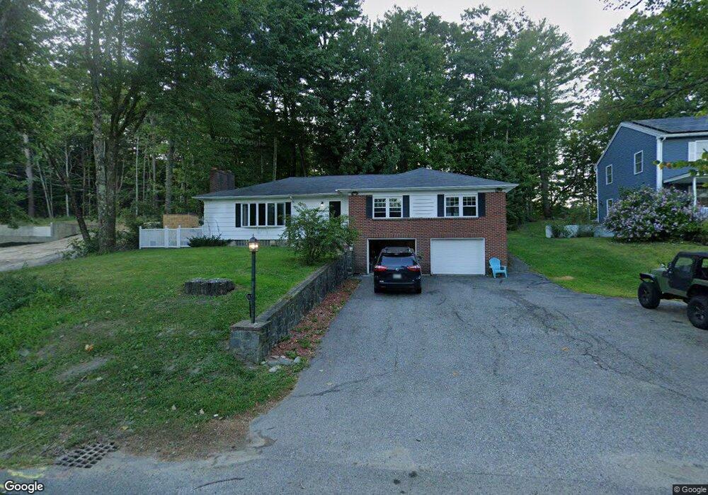
113 Narragansett St Gorham, ME 04038
Estimated Value: $456,000 - $513,000
3
Beds
2
Baths
1,900
Sq Ft
$257/Sq Ft
Est. Value
About This Home
This home is located at 113 Narragansett St, Gorham, ME 04038 and is currently estimated at $488,838, approximately $257 per square foot. 113 Narragansett St is a home located in Cumberland County with nearby schools including Village Elementary School and Gorham High School.
Ownership History
Date
Name
Owned For
Owner Type
Purchase Details
Closed on
Apr 10, 2019
Sold by
Flagg Russell D
Bought by
Keenan Samantha
Current Estimated Value
Purchase Details
Closed on
Jul 8, 2011
Sold by
Peters Elsie W Est
Bought by
Keenan Samantha L and Flagg Russell D
Home Financials for this Owner
Home Financials are based on the most recent Mortgage that was taken out on this home.
Original Mortgage
$178,360
Interest Rate
4.5%
Mortgage Type
FHA
Create a Home Valuation Report for This Property
The Home Valuation Report is an in-depth analysis detailing your home's value as well as a comparison with similar homes in the area
Home Values in the Area
Average Home Value in this Area
Purchase History
| Date | Buyer | Sale Price | Title Company |
|---|---|---|---|
| Keenan Samantha | -- | -- | |
| Keenan Samantha L | -- | -- |
Source: Public Records
Mortgage History
| Date | Status | Borrower | Loan Amount |
|---|---|---|---|
| Previous Owner | Keenan Samantha L | $178,360 |
Source: Public Records
Tax History Compared to Growth
Tax History
| Year | Tax Paid | Tax Assessment Tax Assessment Total Assessment is a certain percentage of the fair market value that is determined by local assessors to be the total taxable value of land and additions on the property. | Land | Improvement |
|---|---|---|---|---|
| 2024 | $4,919 | $334,600 | $98,100 | $236,500 |
| 2023 | $4,601 | $334,600 | $98,100 | $236,500 |
| 2022 | $4,300 | $334,600 | $98,100 | $236,500 |
| 2021 | $3,731 | $192,300 | $71,300 | $121,000 |
| 2020 | $3,654 | $192,300 | $71,300 | $121,000 |
| 2019 | $3,644 | $192,300 | $71,300 | $121,000 |
| 2018 | $3,500 | $192,300 | $71,300 | $121,000 |
| 2017 | $3,288 | $192,300 | $71,300 | $121,000 |
| 2016 | $3,271 | $192,400 | $71,400 | $121,000 |
| 2015 | $3,136 | $192,400 | $71,400 | $121,000 |
| 2014 | $3,247 | $186,600 | $77,000 | $109,600 |
| 2013 | $3,228 | $186,600 | $77,000 | $109,600 |
Source: Public Records
Map
Nearby Homes
- 114 Narragansett St
- 52 Morrill Ave
- 151 South St
- 6 Midnight Way
- 53 Lochwood Dr
- 49 Lochwood Dr
- 34 Baxter Ln Unit 10
- 17 Boreal Dr
- 30 Boreal Dr
- TBD Lochwood Dr
- 127 Falcon Crest Dr Unit 4
- 282 South St
- 8 Western Ave
- 12 Richard Rd
- 181 Falcon Crest Dr Unit 27
- 183 Falcon Crest Dr Unit 28
- 185 Falcon Crest Dr Unit 29
- 187 Falcon Crest Dr Unit 30
- 189 Falcon Crest Dr Unit 31
- 191 Falcon Crest Dr Unit 32
- 109 Narragansett St
- 117 Narragansett St
- TBD Narragansett St
- 121 Narragansett St
- 107 Narragansett St
- 118 Narragansett St
- 110 Narragansett St
- 122 Narragansett St
- 122 Narragansett St
- 103 Narragansett St
- 115 Narragansett St
- 104 Narragansett St
- 126 Narragansett St
- 129 Narragansett St
- 99 Narragansett St
- 96 Narragansett St
- 130 Narragansett St
- 133 Narragansett St
- 95 Narragansett St
- 132 Narragansett St