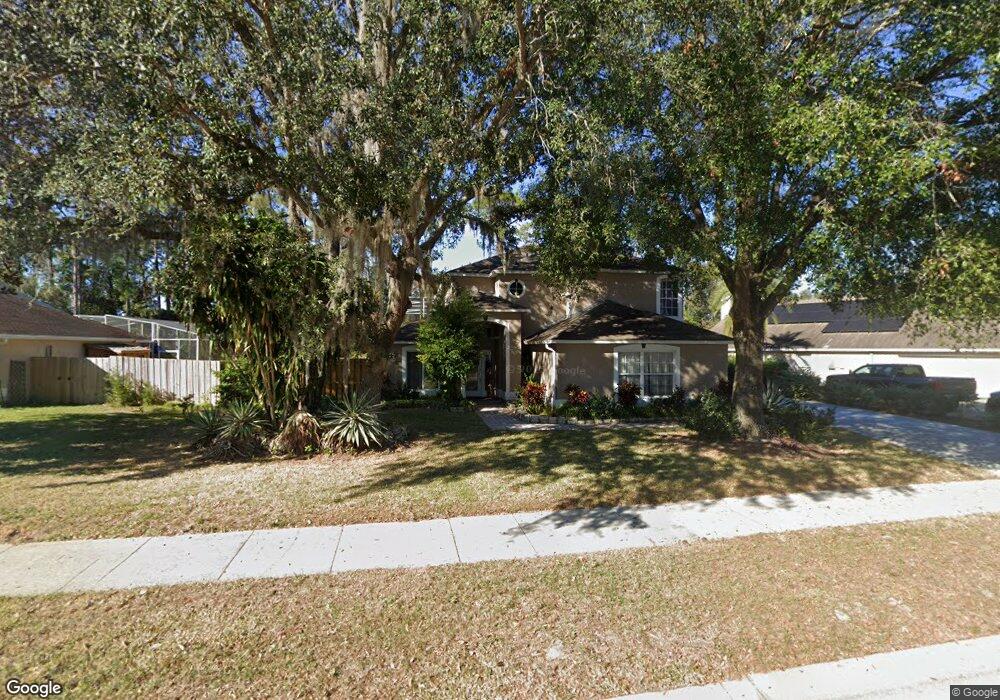
113 Oakpoint Cir Davenport, FL 33837
Estimated Value: $305,000 - $376,000
3
Beds
2
Baths
1,746
Sq Ft
$198/Sq Ft
Est. Value
About This Home
This home is located at 113 Oakpoint Cir, Davenport, FL 33837 and is currently estimated at $345,049, approximately $197 per square foot. 113 Oakpoint Cir is a home located in Polk County with nearby schools including Davenport School Of The Arts, Loughman Oaks Elementary School, and Dundee Elementary Academy.
Ownership History
Date
Name
Owned For
Owner Type
Purchase Details
Closed on
Jan 29, 2004
Sold by
Miller Michael S and Miller Laura L
Bought by
Lawrence Amy
Current Estimated Value
Purchase Details
Closed on
Jul 31, 1995
Sold by
Southfield Homes Corp
Bought by
Miller Michael S and Miller Laura L
Home Financials for this Owner
Home Financials are based on the most recent Mortgage that was taken out on this home.
Original Mortgage
$104,250
Interest Rate
7.54%
Create a Home Valuation Report for This Property
The Home Valuation Report is an in-depth analysis detailing your home's value as well as a comparison with similar homes in the area
Home Values in the Area
Average Home Value in this Area
Purchase History
| Date | Buyer | Sale Price | Title Company |
|---|---|---|---|
| Lawrence Amy | $192,000 | Equitable Title Agency Inc | |
| Miller Michael S | $139,000 | -- |
Source: Public Records
Mortgage History
| Date | Status | Borrower | Loan Amount |
|---|---|---|---|
| Previous Owner | Miller Michael S | $104,250 |
Source: Public Records
Tax History Compared to Growth
Tax History
| Year | Tax Paid | Tax Assessment Tax Assessment Total Assessment is a certain percentage of the fair market value that is determined by local assessors to be the total taxable value of land and additions on the property. | Land | Improvement |
|---|---|---|---|---|
| 2025 | $1,540 | $108,532 | -- | -- |
| 2024 | $1,381 | $105,473 | -- | -- |
| 2023 | $1,381 | $102,401 | $0 | $0 |
| 2022 | $1,308 | $99,418 | $0 | $0 |
| 2021 | $1,286 | $96,522 | $0 | $0 |
| 2020 | $1,253 | $95,189 | $0 | $0 |
| 2018 | $1,188 | $91,314 | $0 | $0 |
| 2017 | $1,164 | $89,436 | $0 | $0 |
| 2016 | $1,122 | $87,596 | $0 | $0 |
| 2015 | $739 | $86,987 | $0 | $0 |
| 2014 | $1,057 | $86,297 | $0 | $0 |
Source: Public Records
Map
Nearby Homes
- 135 Bayhead St
- 1295 Pinewood Dr
- 1230 Pinewood Dr
- 1265 Pinewood Dr
- 1301 Pinewood Dr
- 1283 Pinewood Dr
- 1271 Pinewood Dr
- 1224 Pinewood Dr
- 1218 Pinewood Dr
- 1277 Pinewood Dr
- 1289 Pinewood Dr
- 2359 Lancashire St
- 2375 Lancashire St
- 2260 Derwent Dr
- 2355 Lancashire St
- 1717 Ronald Reagan Pkwy
- 632 Pinewood Dr
- 815 Thousand Oaks Blvd
- 680 Thousand Oaks Blvd
- 120 Terrace Ridge Cir Unit 120
- 123 Oakpoint Cir
- 103 Oakpoint Cir
- 207 Oakpoint Cir
- 205 Baypoint Dr
- 767 Oakpoint Cir
- 217 Oakpoint Cir
- 162 Baypoint Dr
- 215 Baypoint Dr
- 757 Oakpoint Cir
- 152 Baypoint Dr
- 758 Oakpoint Cir
- 142 Baypoint Dr
- 214 Baypoint Dr
- 214 Oakpoint Cir
- 227 Oakpoint Cir
- 225 Baypoint Dr
- 748 Oakpoint Cir
- 747 Oakpoint Cir
- 132 Baypoint Dr
- 224 Baypoint Dr