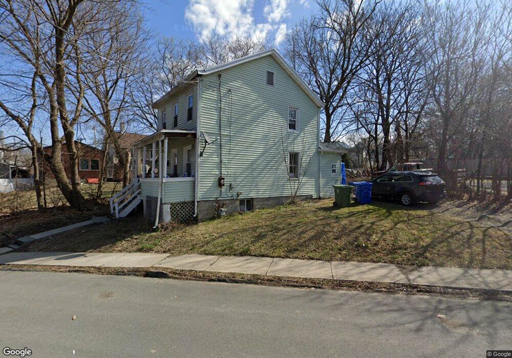
113 Railroad Ave Middletown, NY 10940
Estimated Value: $193,680 - $277,000
3
Beds
2
Baths
936
Sq Ft
$257/Sq Ft
Est. Value
About This Home
This home is located at 113 Railroad Ave, Middletown, NY 10940 and is currently estimated at $240,420, approximately $256 per square foot. 113 Railroad Ave is a home located in Orange County with nearby schools including William A. Carter School, Middletown Twin Towers Middle School, and Monhagen Middle School.
Ownership History
Date
Name
Owned For
Owner Type
Purchase Details
Closed on
Nov 2, 2004
Sold by
Rosado Linda Mae
Bought by
Rosado Angelo L
Current Estimated Value
Purchase Details
Closed on
Oct 21, 2004
Sold by
Bruce Ellison As Sole Distr Of Joan Ellison
Bought by
Roasado Linda Mae
Purchase Details
Closed on
Oct 2, 1998
Sold by
Cherry Leonard and Cherry James H
Bought by
Cherry Leonard and Cherry James H
Purchase Details
Closed on
Aug 18, 1998
Sold by
Cherry Leonard
Bought by
Cherry Leonard and Cherry James H
Purchase Details
Closed on
Sep 5, 1995
Sold by
Bradner Nora A and Mccloud Nora A
Bought by
Bradner Nora A and Cherry Leonard
Create a Home Valuation Report for This Property
The Home Valuation Report is an in-depth analysis detailing your home's value as well as a comparison with similar homes in the area
Home Values in the Area
Average Home Value in this Area
Purchase History
| Date | Buyer | Sale Price | Title Company |
|---|---|---|---|
| Rosado Angelo L | -- | James Mccarl | |
| Roasado Linda Mae | $40,000 | James R Mccarl | |
| Cherry Leonard | -- | -- | |
| Cherry Leonard | -- | -- | |
| Bradner Nora A | -- | -- |
Source: Public Records
Tax History Compared to Growth
Tax History
| Year | Tax Paid | Tax Assessment Tax Assessment Total Assessment is a certain percentage of the fair market value that is determined by local assessors to be the total taxable value of land and additions on the property. | Land | Improvement |
|---|---|---|---|---|
| 2024 | $3,432 | $12,500 | $4,300 | $8,200 |
| 2023 | $3,432 | $12,500 | $4,300 | $8,200 |
| 2022 | $3,361 | $12,500 | $4,300 | $8,200 |
| 2021 | $3,536 | $12,500 | $4,300 | $8,200 |
| 2020 | $1,448 | $12,500 | $4,300 | $8,200 |
| 2019 | $1,409 | $12,500 | $4,300 | $8,200 |
| 2018 | $3,358 | $12,500 | $4,300 | $8,200 |
| 2017 | $3,256 | $12,500 | $4,300 | $8,200 |
| 2016 | $3,264 | $12,500 | $4,300 | $8,200 |
| 2015 | -- | $12,500 | $4,300 | $8,200 |
| 2014 | -- | $12,500 | $4,300 | $8,200 |
Source: Public Records
Map
Nearby Homes
- 10 Myrtle Ave
- 20 Benton Ave
- 221 E Main St
- 44 Houston Ave
- 256 E Main St
- 29 Little Ave
- 13 Forest Ave
- 214 Phillips St
- 17 Little Ave
- 31 Beattie Ave
- 77 Prince St
- 47 Prince St
- 28 Spring St
- 96-96.5 Beattie Ave Unit 2
- 19-21 Wilson St
- 17 Magnolia Park Rd
- 2 Danielle Ct
- 80 Beattie Ave
- 100 Excelsior Ave
- 13 Smith St
- 115 Railroad Ave
- 111 Railroad Ave
- 12 Myrtle Ave
- 1 Charles St
- 14 Myrtle Ave
- 1 Sprague Ave
- 1 Sprague Ave
- 1 Sprague Ave
- 1 Sprague Ave
- 1 Sprague Ave
- 1 Sprague Ave Unit 1
- 12 1/2 Myrtle Ave
- 3 Charles St Unit 2
- 3 Charles St Unit 1a
- 3 Charles St
- 5 Charles St
- 18 Myrtle Ave
- 20 Myrtle Ave
- 9 Myrtle Ave
- 7 Myrtle Ave