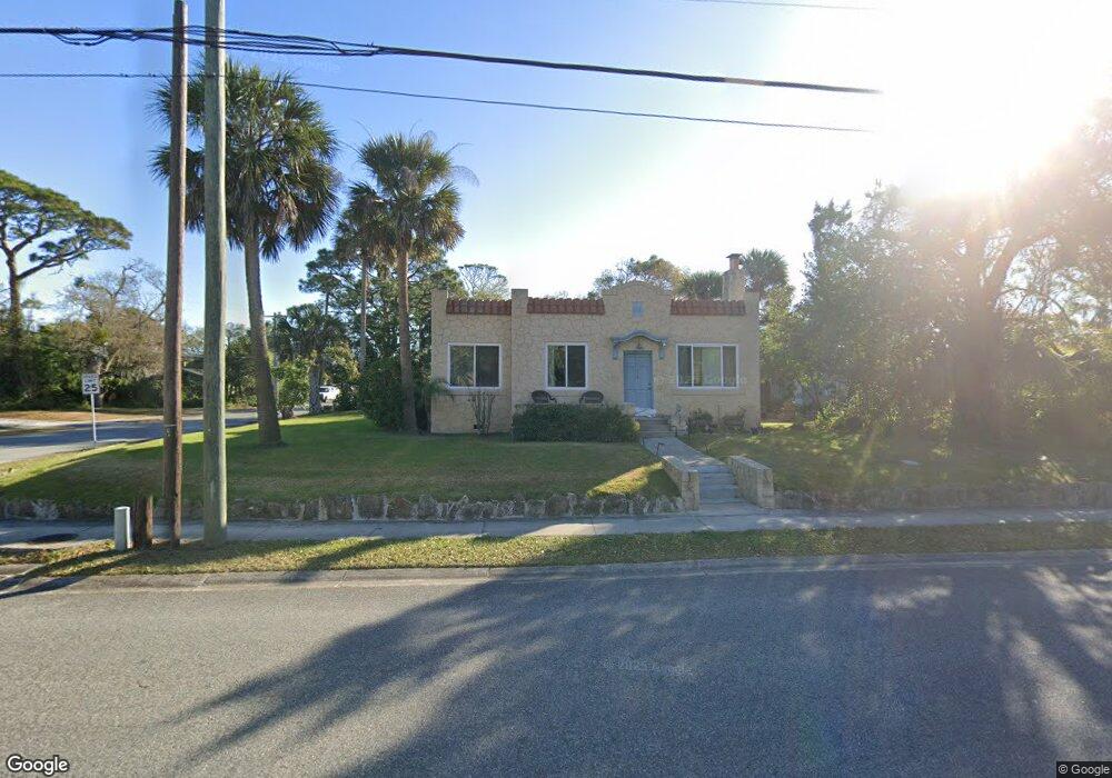
113 S Halifax Dr Ormond Beach, FL 32176
Estimated Value: $337,918 - $385,000
3
Beds
2
Baths
1,547
Sq Ft
$233/Sq Ft
Est. Value
About This Home
This home is located at 113 S Halifax Dr, Ormond Beach, FL 32176 and is currently estimated at $359,980, approximately $232 per square foot. 113 S Halifax Dr is a home located in Volusia County with nearby schools including Ormond Beach Middle School, Seabreeze High School, and St Brendan Catholic School.
Ownership History
Date
Name
Owned For
Owner Type
Purchase Details
Closed on
Feb 7, 2019
Sold by
Willwerth Gary R and Willwerth Ilene
Bought by
Vanyo Susan
Current Estimated Value
Purchase Details
Closed on
Jan 12, 2001
Sold by
Marcelonis Marilyn Gwen
Bought by
Willwerth Gary R and Willwerth Ilena
Purchase Details
Closed on
Jan 15, 1993
Bought by
Willwerth Gary R and Willwerth Ilene
Purchase Details
Closed on
Jun 15, 1988
Bought by
Willwerth Gary R and Willwerth Ilene
Purchase Details
Closed on
Nov 15, 1984
Bought by
Willwerth Gary R and Willwerth Ilene
Create a Home Valuation Report for This Property
The Home Valuation Report is an in-depth analysis detailing your home's value as well as a comparison with similar homes in the area
Home Values in the Area
Average Home Value in this Area
Purchase History
| Date | Buyer | Sale Price | Title Company |
|---|---|---|---|
| Vanyo Susan | $242,500 | Public Title Services Llc | |
| Willwerth Gary R | $157,000 | -- | |
| Willwerth Gary R | $100 | -- | |
| Willwerth Gary R | $64,000 | -- | |
| Willwerth Gary R | $100 | -- |
Source: Public Records
Tax History Compared to Growth
Tax History
| Year | Tax Paid | Tax Assessment Tax Assessment Total Assessment is a certain percentage of the fair market value that is determined by local assessors to be the total taxable value of land and additions on the property. | Land | Improvement |
|---|---|---|---|---|
| 2025 | $3,914 | $281,610 | $121,130 | $160,480 |
| 2024 | $3,208 | $282,355 | $121,130 | $161,225 |
| 2023 | $3,208 | $238,081 | $83,129 | $154,952 |
| 2022 | $2,858 | $203,264 | $63,788 | $139,476 |
| 2021 | $2,558 | $145,343 | $51,913 | $93,430 |
| 2020 | $2,468 | $140,200 | $51,461 | $88,739 |
| 2019 | $2,505 | $141,116 | $51,461 | $89,655 |
| 2018 | $1,019 | $97,263 | $0 | $0 |
| 2017 | $1,026 | $95,262 | $0 | $0 |
| 2016 | $1,028 | $93,303 | $0 | $0 |
| 2015 | $1,058 | $92,654 | $0 | $0 |
| 2014 | $1,049 | $91,919 | $0 | $0 |
Source: Public Records
Map
Nearby Homes
- 113 S Halifax Dr
- 39 Bosarvey Cir
- 55 Vining Ct
- 101 Lucky Dr
- 1 John Anderson Dr Unit 604
- 1 John Anderson Dr Unit 615
- 1 John Anderson Dr Unit 2050
- 0 0 Unit MFRO6285485
- 111 S Atlantic Ave Unit 505
- 111 S Atlantic Ave Unit 702
- 111 S Atlantic Ave Unit 1104
- 111 S Atlantic Ave Unit 803
- 111 S Atlantic Ave Unit 304
- 111 S Atlantic Ave Unit 405
- 169 Valencia Dr
- 89 S Atlantic Ave Unit 401
- 89 S Atlantic Ave Unit 404
- 89 S Atlantic Ave Unit 1006
- 89 S Atlantic Ave Unit 204
- 89 S Atlantic Ave Unit 103
- 113 S Halifax Dr Unit A
- 80 Bosarvey Dr
- 60 Bosarvey Cir
- 50 Bosarvey Cir
- 127 S Halifax Dr
- 99 S Halifax Dr
- 130 Seton Trail
- 133 S Halifax Dr
- 87 Bosarvey Dr
- 59 Bosarvey Cir
- 91 S Halifax Dr
- 134 Seton Trail
- 90 Seton Trail
- 128 S Halifax Dr
- 141 S Halifax Dr
- 111 Seton Trail
- 83 S Halifax Dr
- 119 Seton Trail
- 142 S Halifax Dr
- 88 S Halifax Dr