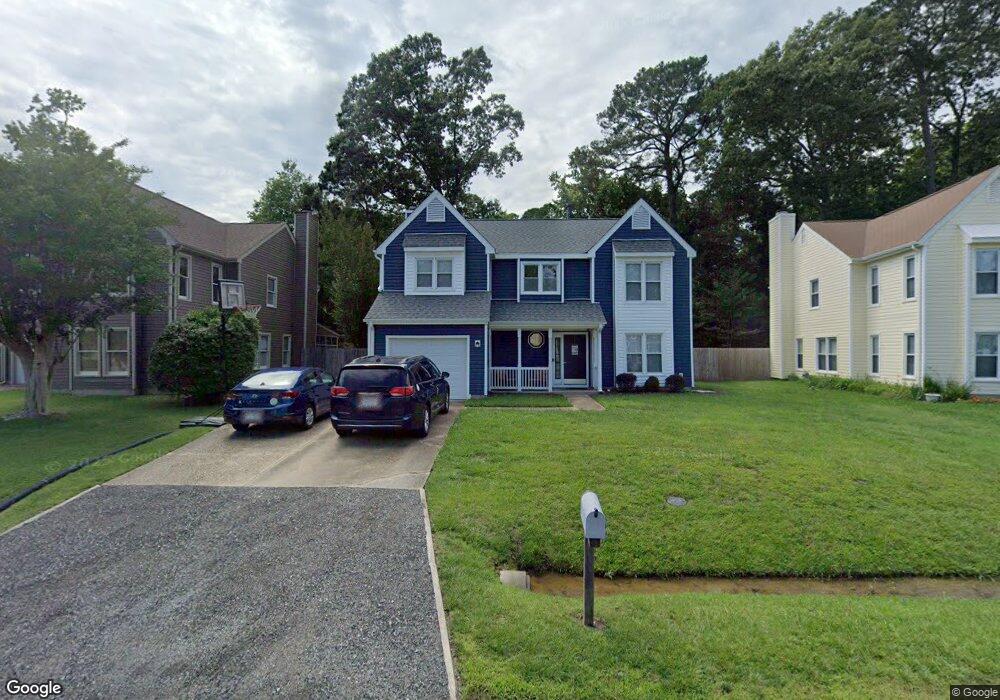
113 Sheffield Ln Yorktown, VA 23693
Tabb NeighborhoodEstimated Value: $426,000 - $447,143
4
Beds
3
Baths
1,949
Sq Ft
$224/Sq Ft
Est. Value
About This Home
This home is located at 113 Sheffield Ln, Yorktown, VA 23693 and is currently estimated at $436,286, approximately $223 per square foot. 113 Sheffield Ln is a home located in York County with nearby schools including Tabb Elementary School, Tabb Middle School, and Tabb High School.
Ownership History
Date
Name
Owned For
Owner Type
Purchase Details
Closed on
Jan 10, 2019
Sold by
Stephens Larry F
Bought by
Robidas Melissa K
Current Estimated Value
Home Financials for this Owner
Home Financials are based on the most recent Mortgage that was taken out on this home.
Original Mortgage
$263,500
Outstanding Balance
$232,138
Interest Rate
4.7%
Mortgage Type
New Conventional
Estimated Equity
$204,148
Create a Home Valuation Report for This Property
The Home Valuation Report is an in-depth analysis detailing your home's value as well as a comparison with similar homes in the area
Home Values in the Area
Average Home Value in this Area
Purchase History
| Date | Buyer | Sale Price | Title Company |
|---|---|---|---|
| Robidas Melissa K | $310,000 | Attorney |
Source: Public Records
Mortgage History
| Date | Status | Borrower | Loan Amount |
|---|---|---|---|
| Open | Robidas Melissa K | $263,500 |
Source: Public Records
Tax History Compared to Growth
Tax History
| Year | Tax Paid | Tax Assessment Tax Assessment Total Assessment is a certain percentage of the fair market value that is determined by local assessors to be the total taxable value of land and additions on the property. | Land | Improvement |
|---|---|---|---|---|
| 2025 | $2,626 | $354,800 | $125,000 | $229,800 |
| 2024 | $2,626 | $354,800 | $125,000 | $229,800 |
| 2023 | $2,458 | $319,200 | $125,000 | $194,200 |
| 2022 | $2,490 | $319,200 | $125,000 | $194,200 |
| 2021 | $2,421 | $304,500 | $122,000 | $182,500 |
| 2020 | $2,421 | $304,500 | $122,000 | $182,500 |
| 2019 | $3,247 | $284,800 | $120,000 | $164,800 |
| 2018 | $3,247 | $284,800 | $120,000 | $164,800 |
| 2017 | $2,109 | $280,700 | $116,000 | $164,700 |
| 2016 | $2,109 | $280,700 | $116,000 | $164,700 |
| 2015 | -- | $288,500 | $116,000 | $172,500 |
| 2014 | -- | $288,500 | $116,000 | $172,500 |
Source: Public Records
Map
Nearby Homes
- 106 Robin Hood Dr
- 201 Amersham Dr Unit B
- 104 Camden Way
- 104 Camden Way Unit G
- 105 Clydesdale Dr
- 103 Pohick Run
- 137 White Cedar Ln
- 104 Blackwood Ct
- 706 Kanawah Run
- 201 Cape Landing
- 103 Cape Landing
- 111 Hautz Way
- 209 Cattail Ln
- 212 Tabb Smith Trail
- 101 Nanticoke Turn
- 323 Vista Point Dr
- 401 Tabb Smith Trail
- 305 Chaptico Run
- 314 Vista Point Dr
- 6+ AC Vista Point Dr
- 111 Sheffield Ln
- 115 Sheffield Ln
- 109 Sheffield Ln
- 117 Sheffield Ln
- 112 Sheffield Ln
- 107 Sheffield Ln
- 114 Sheffield Ln
- 110 Sheffield Ln
- 108 Sheffield Ln
- 116 Sheffield Ln
- 101 W Bristol Ln
- 105 Sheffield Ln
- 103 W Bristol Ln
- 106 Sheffield Ln
- 3105 Hampton Hwy
- 118 Sheffield Ln
- 103 Sheffield Ln
- 118 Chippenham Dr Unit E
- 118 Chippenham Dr Unit D
- 118 Chippenham Dr Unit F