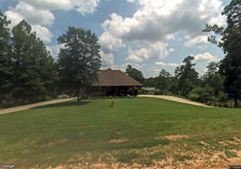
1131 Camp Branch Cir Alabaster, AL 35007
Estimated Value: $740,000 - $1,172,000
--
Bed
3
Baths
5,030
Sq Ft
$186/Sq Ft
Est. Value
About This Home
This home is located at 1131 Camp Branch Cir, Alabaster, AL 35007 and is currently estimated at $937,793, approximately $186 per square foot. 1131 Camp Branch Cir is a home located in Shelby County with nearby schools including Thompson Intermediate School, Thompson Middle School, and Thompson High School.
Ownership History
Date
Name
Owned For
Owner Type
Purchase Details
Closed on
Jan 10, 2023
Sold by
Cox Lynn L and Cox Stacie L
Bought by
Cox Lynn L
Current Estimated Value
Purchase Details
Closed on
Jul 11, 2021
Sold by
Cox Lynn L
Bought by
Cox Lynn L and Armstrong Mullins Stacie
Purchase Details
Closed on
Dec 15, 2005
Sold by
Johnsie E Moore Revocable Trust
Bought by
Norris Mary
Home Financials for this Owner
Home Financials are based on the most recent Mortgage that was taken out on this home.
Original Mortgage
$590,000
Interest Rate
6.23%
Mortgage Type
Credit Line Revolving
Purchase Details
Closed on
Jan 18, 2000
Sold by
Moore Johnsie
Bought by
Pennington Holly M and Moore Johnsie
Home Financials for this Owner
Home Financials are based on the most recent Mortgage that was taken out on this home.
Original Mortgage
$170,000
Interest Rate
7.87%
Create a Home Valuation Report for This Property
The Home Valuation Report is an in-depth analysis detailing your home's value as well as a comparison with similar homes in the area
Home Values in the Area
Average Home Value in this Area
Purchase History
| Date | Buyer | Sale Price | Title Company |
|---|---|---|---|
| Cox Lynn L | -- | -- | |
| Cox Lynn L | -- | None Available | |
| Cox Lynn L | -- | None Listed On Document | |
| Norris Mary | -- | None Available | |
| Pennington Holly M | $500 | -- |
Source: Public Records
Mortgage History
| Date | Status | Borrower | Loan Amount |
|---|---|---|---|
| Previous Owner | Norris Mary | $590,000 | |
| Previous Owner | Pennington Holly M | $170,000 |
Source: Public Records
Tax History Compared to Growth
Tax History
| Year | Tax Paid | Tax Assessment Tax Assessment Total Assessment is a certain percentage of the fair market value that is determined by local assessors to be the total taxable value of land and additions on the property. | Land | Improvement |
|---|---|---|---|---|
| 2024 | $3,080 | $70,000 | $0 | $0 |
| 2023 | $2,205 | $63,800 | $0 | $0 |
| 2022 | $2,009 | $58,580 | $0 | $0 |
| 2021 | $1,851 | $54,360 | $0 | $0 |
| 2020 | $0 | $52,540 | $0 | $0 |
| 2019 | $1,798 | $50,680 | $0 | $0 |
| 2017 | $1,798 | $52,940 | $0 | $0 |
| 2015 | $1,921 | $51,620 | $0 | $0 |
| 2014 | $1,692 | $50,120 | $0 | $0 |
Source: Public Records
Map
Nearby Homes
- 1134 Camp Branch Cir
- 960 Camp Branch Rd
- 15 Silver Ln
- 207 Stetson Ln
- 2041 Lonesome Hen Ln
- 226 Thoroughbred Ln
- 105 Quarterhorse Ln
- 153 Shetland Trail Unit 201
- 119 Walking Horse Trace Unit 17
- 00 Deer Run Rd
- 327 Ridgeview Lake Rd
- 551 Oakmont Dr Unit 3
- 2 Oakmont Dr Unit 2
- 3 Oakmont Dr Unit 3
- 00 Highway 87 Unit 1
- 314 Highway 331
- 137 Broadmoor Ln
- 0 U S Highway 31 Unit 21397981
- 303 Chestnut Ln
- 156 Lauchlin Ln
- 1161 Camp Branch Cir
- 600 Camp Branch Rd
- 1134 Camp Branch Cir Unit 1
- 644 Camp Branch Rd
- 520 Camp Branch Rd
- 774 Camp Branch Rd
- 735 Camp Branch Rd
- 35 Ballard Ln
- 505 Camp Branch Rd
- 565 Camp Branch Rd
- 645 Camp Branch Cir
- 585 Camp Branch Cir
- 721 Camp Branch Cir
- 745 Camp Branch Cir
- 707 Camp Branch Rd
- 561 Camp Branch Rd
- 841 Camp Branch Cir
- 678 Camp Branch Cir
- 700 Camp Branch Cir
- 788 Camp Branch Cir