
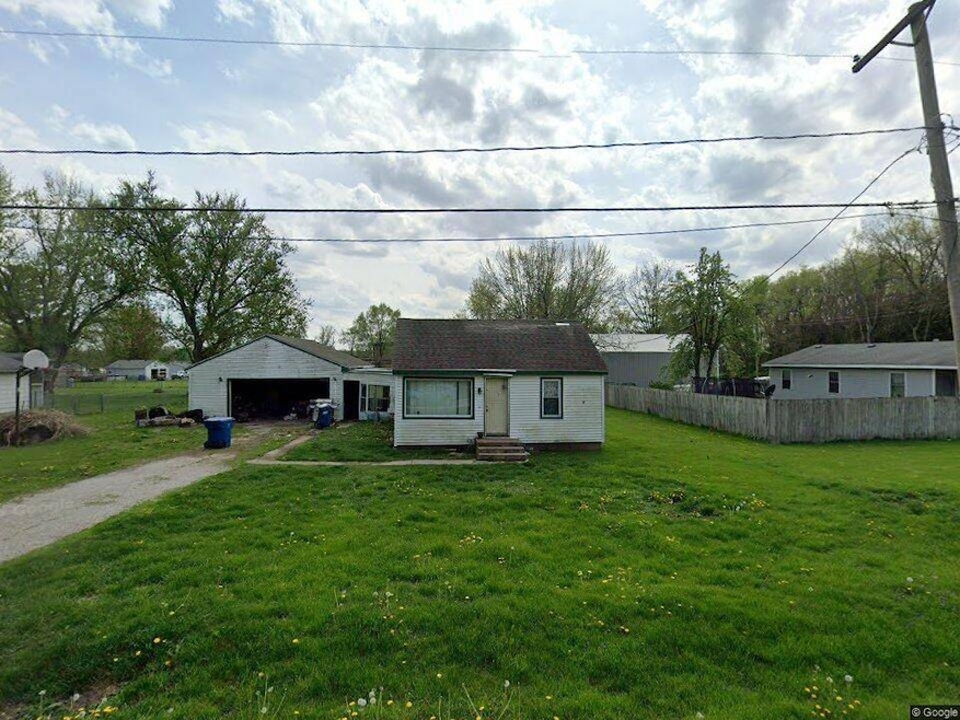
1131 Chestnut St Buffalo, IA 52728
Estimated payment $312/month
2
Beds
2
Baths
912
Sq Ft
$55
Price per Sq Ft
About This Home
Have the best of both worlds. Join the Buffalo IA community. Enjoy life in this river town that gives you access to the Quad Cities or a quick trip on the Great River Road to Muscatine. A compact home with garage and yard that gives you plenty of green space. Interior photos coming soon!
Home Details
Home Type
- Single Family
Est. Annual Taxes
- $1,648
Year Built
- Built in 1948
Lot Details
- 0.46 Acre Lot
Parking
- 2 Car Garage
Home Design
- 912 Sq Ft Home
- Bungalow
Bedrooms and Bathrooms
- 2 Bedrooms
- 2 Full Bathrooms
Map
Create a Home Valuation Report for This Property
The Home Valuation Report is an in-depth analysis detailing your home's value as well as a comparison with similar homes in the area
Home Values in the Area
Average Home Value in this Area
Tax History
| Year | Tax Paid | Tax Assessment Tax Assessment Total Assessment is a certain percentage of the fair market value that is determined by local assessors to be the total taxable value of land and additions on the property. | Land | Improvement |
|---|---|---|---|---|
| 2025 | $1,648 | $118,900 | $35,000 | $83,900 |
| 2024 | $1,570 | $115,400 | $35,000 | $80,400 |
| 2023 | $1,198 | $115,400 | $35,000 | $80,400 |
| 2022 | $1,266 | $76,790 | $14,310 | $62,480 |
| 2021 | $1,266 | $82,130 | $14,310 | $67,820 |
| 2020 | $1,278 | $80,570 | $14,310 | $66,260 |
| 2019 | $1,270 | $77,750 | $14,310 | $63,440 |
| 2018 | $1,240 | $77,750 | $14,310 | $63,440 |
| 2017 | $1,210 | $77,750 | $14,310 | $63,440 |
| 2016 | $1,158 | $74,500 | $0 | $0 |
| 2015 | $1,158 | $71,290 | $0 | $0 |
| 2014 | $1,120 | $71,290 | $0 | $0 |
| 2013 | $1,096 | $0 | $0 | $0 |
| 2012 | -- | $74,830 | $14,310 | $60,520 |
Source: Public Records
Property History
| Date | Event | Price | List to Sale | Price per Sq Ft |
|---|---|---|---|---|
| 11/25/2025 11/25/25 | For Sale | $49,900 | -- | $55 / Sq Ft |
Source: My State MLS
Purchase History
| Date | Type | Sale Price | Title Company |
|---|---|---|---|
| Special Warranty Deed | $27,500 | None Listed On Document | |
| Sheriffs Deed | $38,300 | None Listed On Document | |
| Warranty Deed | -- | None Available |
Source: Public Records
About the Listing Agent
I have been licensed since 1996, owning & operating The Real Estate Store beginning in 1999 . I am an independent Broker/Owner.
I became active and full time again in 2022 after working in the field of insurance and financial services, services to veterans, the under employed, the homeless, disabled and elderly through employment services and case management across the state of Iowa since 2008.
My husband and I rented for 22 years before becoming a homeowners ourselves. We were
Ruth's Other Listings
Source: My State MLS
MLS Number: 11611639
APN: 722143127
Nearby Homes
- 702 - 708 W Front St
- 1240 Spruce St
- 707 3rd St
- 116 Main St
- 516 4th St
- 0 5th St W
- 226 4th Ave W Unit 173
- 9520 115th St
- 3 Chestnut Dr
- 5 E Timberline Dr
- 61 W Timberline Dr
- 8528 101st St W
- 7 Sandpiper Dr
- Lot 02 95th Ave
- Lot 01 95th Ave
- 9933 123rd St
- 6218 114th St
- 13109 83rd Ave
- 9711 106th Ave W
- 1024 S Mississippi St
- 18 Elmwood Dr
- 1115 N Utah Ave
- 1115 N Utah Ave Unit lower lvl apartment
- 3637 Johnson Ave
- 1701 Eagles Crest Ave
- 2325 Mckinley Ave
- 8600 14th St W Unit A2
- 418 S Hancock Ave
- 1000 Blythwood Place
- 3235 W 16th St
- 1400 5th St
- 201 S Howell St Unit 201 Half
- 201 S Howell St
- 201 S Howell St Unit 1/2
- 2002 W 4th St Unit A
- 2002 W 4th St
- 1220 51st Ave
- 1215 18th Ave
- 2504 15th St Unit 4
- 627 N Division St