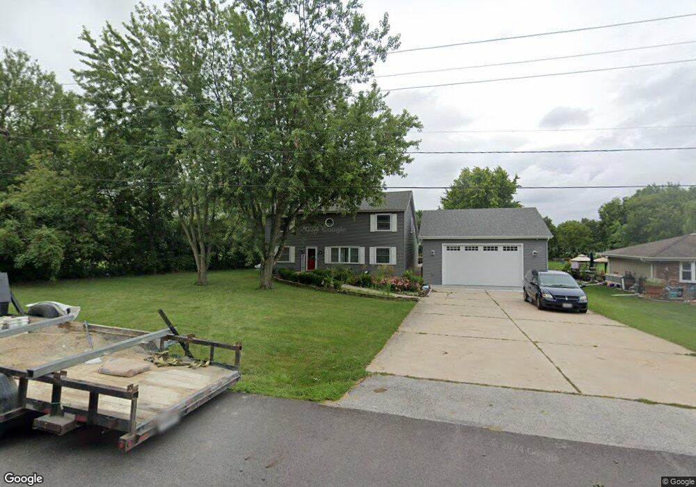
11331 191st St Mokena, IL 60448
Estimated Value: $403,101 - $577,000
4
Beds
4
Baths
2,420
Sq Ft
$193/Sq Ft
Est. Value
About This Home
This home is located at 11331 191st St, Mokena, IL 60448 and is currently estimated at $466,025, approximately $192 per square foot. 11331 191st St is a home located in Will County with nearby schools including Mokena Elementary School, Mokena Intermediate School, and Mokena Jr High School.
Ownership History
Date
Name
Owned For
Owner Type
Purchase Details
Closed on
Apr 30, 2021
Sold by
Leonard Frank G and Ann G Leonard Trust
Bought by
Leonard Cody M
Current Estimated Value
Purchase Details
Closed on
Feb 19, 2021
Sold by
Leonard Ann G
Bought by
Loenard Ann G and Ann G Leonard Trust
Purchase Details
Closed on
Dec 6, 2001
Sold by
Harris Bank Joliet Na
Bought by
Leonard Joseph H and Leonard Ann G
Home Financials for this Owner
Home Financials are based on the most recent Mortgage that was taken out on this home.
Original Mortgage
$45,000
Interest Rate
6.53%
Mortgage Type
Credit Line Revolving
Create a Home Valuation Report for This Property
The Home Valuation Report is an in-depth analysis detailing your home's value as well as a comparison with similar homes in the area
Home Values in the Area
Average Home Value in this Area
Purchase History
| Date | Buyer | Sale Price | Title Company |
|---|---|---|---|
| Leonard Cody M | -- | None Available | |
| Loenard Ann G | -- | None Available | |
| Leonard Joseph H | -- | -- |
Source: Public Records
Mortgage History
| Date | Status | Borrower | Loan Amount |
|---|---|---|---|
| Previous Owner | Leonard Joseph H | $45,000 |
Source: Public Records
Tax History
| Year | Tax Paid | Tax Assessment Tax Assessment Total Assessment is a certain percentage of the fair market value that is determined by local assessors to be the total taxable value of land and additions on the property. | Land | Improvement |
|---|---|---|---|---|
| 2024 | $6,555 | $96,806 | $20,513 | $76,293 |
| 2023 | $6,555 | $86,457 | $18,320 | $68,137 |
| 2022 | $5,749 | $78,747 | $16,686 | $62,061 |
| 2021 | $5,398 | $73,671 | $15,610 | $58,061 |
| 2020 | $5,281 | $71,595 | $15,170 | $56,425 |
| 2019 | $5,110 | $69,679 | $14,764 | $54,915 |
| 2018 | $4,934 | $67,676 | $14,340 | $53,336 |
| 2017 | $4,839 | $66,096 | $14,005 | $52,091 |
| 2016 | $4,698 | $63,830 | $13,525 | $50,305 |
| 2015 | $4,468 | $61,583 | $13,049 | $48,534 |
| 2014 | $4,468 | $61,155 | $12,958 | $48,197 |
| 2013 | $4,468 | $61,948 | $13,126 | $48,822 |
Source: Public Records
Map
Nearby Homes
- 11254 192nd St
- W Maple Rd
- 19380 Wolf Rd Unit 6
- 11617 Parkside Ln
- 18728 S Mill Creek Dr
- 19511 116th Ave Unit D
- 19502 116th Ave Unit C
- 10928 3rd St
- 19545 116th Ave Unit A
- 18714 Wren Cir
- 10814 3rd St
- 10832 Carpenter St
- 18753 Rosewood Ln
- 11321 1st St
- 11325 1st St
- 11317 1st St
- 11329 1st St
- 11319 1st St
- 11323 1st St
- 11315 1st St
Your Personal Tour Guide
Ask me questions while you tour the home.