


1135 Joe Dear Rd Harrisville, MS 39082
Estimated payment $272/month
Highlights
- No HOA
- 1-Story Property
- No Heating
About This Home
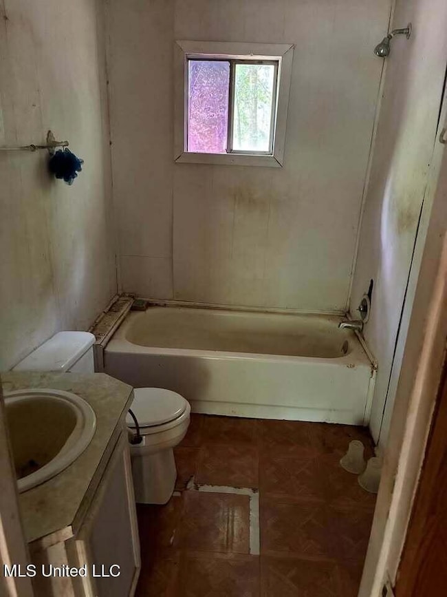
Charming fixer-upper in the Harrisville community! This 1,125 sq. ft. home offers 2 bedrooms, 2 baths, and a bonus room that could serve as a 3rd bedroom. Sitting on 1.88 acres with a natural creek, the property includes a 20x31 shop and a 24x30 concrete pad ideal for an RV, camper, or future projects. Located on a quiet road with excellent potential for renovation or expansion. Bring your vision and make this property your own! SOLD AS-IS
Home Details
Home Type
- Single Family
Est. Annual Taxes
- $487
Year Built
- Built in 1961
Lot Details
- 1.5 Acre Lot
Parking
- Unpaved Parking
Home Design
- Brick Exterior Construction
- Slab Foundation
- Metal Roof
- Siding
Interior Spaces
- 1,125 Sq Ft Home
- 1-Story Property
- Electric Oven
Bedrooms and Bathrooms
- 2 Bedrooms
- 2 Full Bathrooms
Utilities
- No Cooling
- No Heating
Community Details
- No Home Owners Association
- Metes And Bounds Subdivision
Listing and Financial Details
- Assessor Parcel Number 1-0890-29-00000-000-01500
Map
Home Values in the Area
Average Home Value in this Area
Tax History
| Year | Tax Paid | Tax Assessment Tax Assessment Total Assessment is a certain percentage of the fair market value that is determined by local assessors to be the total taxable value of land and additions on the property. | Land | Improvement |
|---|---|---|---|---|
| 2024 | -- | $2,451 | $0 | $0 |
| 2023 | $0 | $2,328 | $0 | $0 |
| 2022 | $145 | $2,234 | $0 | $0 |
| 2021 | $145 | $2,234 | $0 | $0 |
| 2020 | $145 | $2,073 | $0 | $0 |
| 2019 | $145 | $2,142 | $0 | $0 |
| 2018 | $145 | $2,142 | $0 | $0 |
| 2017 | $145 | $2,142 | $0 | $0 |
| 2016 | $145 | $2,179 | $0 | $0 |
| 2015 | $139 | $2,179 | $0 | $0 |
| 2014 | $314 | $3,269 | $0 | $0 |
Property History
| Date | Event | Price | List to Sale | Price per Sq Ft |
|---|---|---|---|---|
| 12/03/2025 12/03/25 | For Sale | $44,000 | -- | $39 / Sq Ft |
Purchase History
| Date | Type | Sale Price | Title Company |
|---|---|---|---|
| Warranty Deed | -- | None Listed On Document | |
| Warranty Deed | -- | None Available | |
| Warranty Deed | -- | -- | |
| Quit Claim Deed | -- | -- | |
| Quit Claim Deed | $1,667 | -- |
Source: MLS United
MLS Number: 4133000
APN: 1-0890-29-00000-000-01500
Disclaimer: Certain information contained herein is derived from information provided by parties other than Homes.com. All information provided is deemed reliable, but is not guaranteed to be accurate and should be independently verified.
![]() Information is deemed to be reliable but not guaranteed. Copyright 2025 MLS United, LLC.
Information is deemed to be reliable but not guaranteed. Copyright 2025 MLS United, LLC.
- 0 Pea Ridge Rd Unit 4101611
- 2294 Simpson Highway 469
- 0 Bridges Rd
- 0 Simpson Highway 469 Unit 4126458
- 502 Buckley Rd
- 130 Blackhawk Dr
- 0 Bones Rd Unit 4131908
- 130 Nevels Dr
- 118 Meadow Woods Rd
- 0 Highway 469 Unit 4128196
- 1 Highway 469 N
- 0 Delancey Rd
- 133 Beaman Dr
- 1511 Highway 469 S
- 866 Old River Rd
- 544 Sunset Ln
- McDonald Rd
- 0 Crisco Rd
- 250 Rockwood Rd
- 222 Byrd Rd
- 103 Rolling Hills Blvd
- 220 S Utica St
- 1531 Chelsea Ln
- 100 Chapel Ridge Dr
- 5590 I-55
- 1000 Spring Lake Blvd
- 12023 Springridge Rd
- 350 Byram Dr
- 100 Byram Dr
- 260 Lowe Cir
- 12025 Springridge Rd
- 360 Barfield Dr
- 301 Elton Park Dr
- 579 Silver Hill Dr
- 560 Silver Hill Dr
- 394 Brookwood Lake Place
- 521 Vista Pointe Dr
- 200 Colony Park Dr
- 2270 Napoleon Ave
- 270 Wildwood Ct
