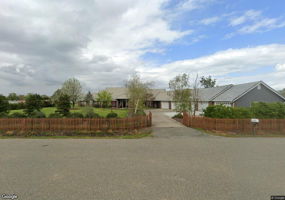
11377 Melea Rd Wilton, CA 95693
Estimated Value: $1,043,159 - $1,479,000
4
Beds
3
Baths
2,801
Sq Ft
$443/Sq Ft
Est. Value
About This Home
This home is located at 11377 Melea Rd, Wilton, CA 95693 and is currently estimated at $1,239,790, approximately $442 per square foot. 11377 Melea Rd is a home located in Sacramento County with nearby schools including C.W. Dillard Elementary School, Katherine L. Albiani Middle School, and Pleasant Grove High School.
Ownership History
Date
Name
Owned For
Owner Type
Purchase Details
Closed on
Jun 11, 2024
Sold by
Seymour-Moquin Robin and Moquin Ronald J
Bought by
Moquin Ronald J and Moquin Robin Seymour
Current Estimated Value
Home Financials for this Owner
Home Financials are based on the most recent Mortgage that was taken out on this home.
Original Mortgage
$250,000
Outstanding Balance
$246,256
Interest Rate
9%
Mortgage Type
Credit Line Revolving
Estimated Equity
$993,534
Purchase Details
Closed on
Oct 9, 2013
Sold by
Moquin Ronald J and Seymour Moquin Robin
Bought by
Moquin Ronald J and Seymour Moquin Robin
Home Financials for this Owner
Home Financials are based on the most recent Mortgage that was taken out on this home.
Original Mortgage
$150,588
Interest Rate
4.55%
Mortgage Type
New Conventional
Purchase Details
Closed on
Feb 6, 2002
Sold by
Cain Moquin Ronald J and Cain Seymour Robin
Bought by
Cain Moquin Ronald J and Cain Seymour Robin
Home Financials for this Owner
Home Financials are based on the most recent Mortgage that was taken out on this home.
Original Mortgage
$180,000
Interest Rate
7.04%
Purchase Details
Closed on
Feb 2, 2000
Sold by
Emanuels Eric S and Emanuels Ann
Bought by
Cain Moquin Ronald J and Cain Seymour Robin
Home Financials for this Owner
Home Financials are based on the most recent Mortgage that was taken out on this home.
Original Mortgage
$178,810
Interest Rate
8.06%
Purchase Details
Closed on
Mar 25, 1996
Sold by
Frank Richard W and Frank Wanda D
Bought by
Emanuels Eric S and Emanuels Ann
Home Financials for this Owner
Home Financials are based on the most recent Mortgage that was taken out on this home.
Original Mortgage
$254,400
Interest Rate
6.98%
Purchase Details
Closed on
Nov 23, 1994
Sold by
Frank Richard W and Frank Wanda D
Bought by
Frank Richard W and Frank Wanda D
Create a Home Valuation Report for This Property
The Home Valuation Report is an in-depth analysis detailing your home's value as well as a comparison with similar homes in the area
Home Values in the Area
Average Home Value in this Area
Purchase History
| Date | Buyer | Sale Price | Title Company |
|---|---|---|---|
| Moquin Ronald J | -- | Atlas Title Company | |
| Moquin Ronald J | -- | Atlas Title Company | |
| Moquin Ronald J | -- | Placer Title Company | |
| Cain Moquin Ronald J | -- | First American Title Ins Co | |
| Cain Moquin Ronald J | $344,000 | Financial Title Company | |
| Emanuels Eric S | $318,500 | Old Republic Title Company | |
| Frank Richard W | -- | -- |
Source: Public Records
Mortgage History
| Date | Status | Borrower | Loan Amount |
|---|---|---|---|
| Open | Moquin Ronald J | $250,000 | |
| Closed | Moquin Ronald J | $250,000 | |
| Previous Owner | Moquin Ronald J | $150,588 | |
| Previous Owner | Cain Moquin Ronald J | $180,000 | |
| Previous Owner | Cain Moquin Ronald J | $178,810 | |
| Previous Owner | Emanuels Eric S | $254,400 |
Source: Public Records
Tax History
| Year | Tax Paid | Tax Assessment Tax Assessment Total Assessment is a certain percentage of the fair market value that is determined by local assessors to be the total taxable value of land and additions on the property. | Land | Improvement |
|---|---|---|---|---|
| 2025 | $5,581 | $607,932 | $153,688 | $454,244 |
| 2024 | $5,581 | $517,581 | $150,675 | $366,906 |
| 2023 | $5,395 | $507,433 | $147,721 | $359,712 |
| 2022 | $5,300 | $497,484 | $144,825 | $352,659 |
| 2021 | $5,246 | $487,731 | $141,986 | $345,745 |
| 2020 | $5,174 | $482,731 | $140,531 | $342,200 |
| 2019 | $5,076 | $473,267 | $137,776 | $335,491 |
| 2018 | $4,936 | $463,988 | $135,075 | $328,913 |
| 2017 | $4,847 | $454,891 | $132,427 | $322,464 |
| 2016 | $4,594 | $445,973 | $129,831 | $316,142 |
| 2015 | $4,505 | $439,275 | $127,881 | $311,394 |
| 2014 | $4,427 | $430,671 | $125,376 | $305,295 |
Source: Public Records
Map
Nearby Homes
- 0 Davis Rd Unit 226005785
- 0 Parcel D Unit 226001796
- 11529 Arno Rd
- 11276 Randolph Rd
- 7770 Dillard Rd
- 0 Colony Rd Unit 225137072
- 0 Alta Mesa Rd Unit 224117427
- 0 Blake Rd
- 10600 Colony Rd
- #1 Alta Mesa Rd
- 9425 Montevideo Dr
- 10676 Wilton Rd
- 11213 Colony Rd
- 0 Woods Rd Unit SR25200996
- 11490 Arno Rd
- 11343-2 Arno Rd
- 11343-4 Arno Rd
- 5-acres Hobday Rd
- 10412 Sheldon Rd
- 12800 Rimfire Dr
- 11378 Melea Rd
- 11367 Melea Rd
- 11368 Melea Rd
- 11420 Haggie Rd
- 0 Haggie Rd Unit 20009532
- 0 Haggie Rd Unit 20000522
- 0 Haggie Rd Unit 19052322
- 11440 Haggie Rd
- 11395 Haggie Rd
- 11413 Haggie Rd
- 11458 Haggie Rd
- 11365 Haggie Rd
- 11317 Melea Rd
- 11318 Melea Rd
- 11441 Haggie Rd
- 10017 Davis Rd
- 9999 Davis Rd
- 10093 Davis Rd
- 11465 Haggie Rd
- 10018 Davis Rd
Your Personal Tour Guide
Ask me questions while you tour the home.