
Seller's Agent in 2025
Julie Wheeless
Keller Williams Realty Urban Elite
(303) 210-6340
1 in this area
34 Total Sales
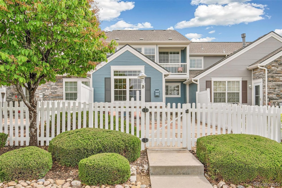
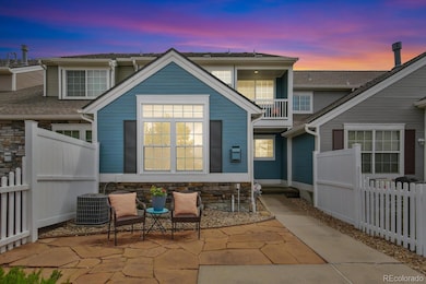

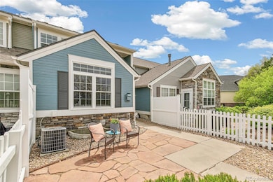
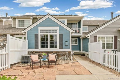
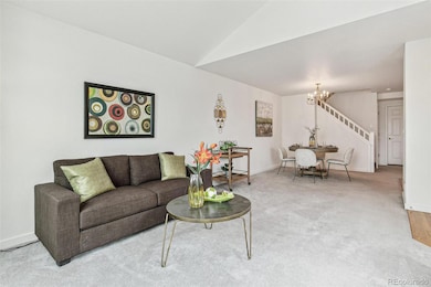
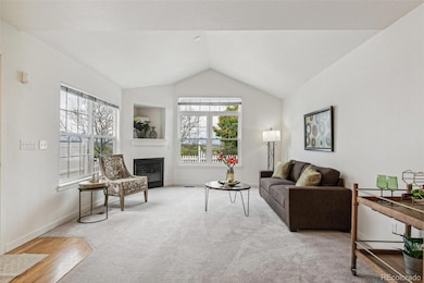
** Charming Townhome-Style Condo with Mountain Views in North Central Westminster ** Welcome to this beautifully maintained townhome-style condo located in the highly sought-after Stratford Lakes community. Owned by the original owner, this home offers stunning views of the city park and Longs Peak, making it a rare find. The gated front patio provides a peaceful space to relax and take in the mountain scenery, while the surrounding parks, lakes, and walking trails offer endless outdoor enjoyment right outside your door. Inside, the main level offers an open floor plan with a spacious kitchen, dining area, and living room. Cozy up by the gas fireplace in the living room while enjoying uninterrupted views. Upstairs, you’ll find two generously sized bedroom suites, each designed for comfort and privacy. The primary suite features a private balcony—the perfect spot to watch the sunset over Longs Peak - and there is plenty of room for a reading nook or home office. If an extra bedroom is desired, the extra large 2nd bedroom can be easily converted back to 2 separate rooms. An unfinished basement with an egress window provides ample storage or the opportunity to finish and customize the space to your needs. The south-facing 2-car garage adds extra convenience and additional storage space. Enjoy all the amenities Stratford Lakes has to offer, including a pool and tennis courts, and take evening strolls through this picturesque neighborhood. Located in the College Hills area, you’ll love the easy access to restaurants, public transportation, shopping, and a nearby golf course. This well maintained home is just the gift you need for all your summer fun! Check out www.11386grove.com
Last Agent to Sell the Property
Keller Williams Realty Urban Elite Brokerage Phone: 303-210-6340 License #100088866 Listed on: 05/09/2025
| Date | Type | Sale Price | Title Company |
|---|---|---|---|
| Special Warranty Deed | $459,500 | Fidelity National Title | |
| Warranty Deed | $264,434 | Land Title Guarantee Company |
| Date | Status | Loan Amount | Loan Type |
|---|---|---|---|
| Open | $384,500 | VA | |
| Previous Owner | $130,000 | No Value Available |
| Date | Event | Price | List to Sale | Price per Sq Ft |
|---|---|---|---|---|
| 08/20/2025 08/20/25 | Sold | $459,500 | -3.8% | $298 / Sq Ft |
| 06/07/2025 06/07/25 | For Sale | $477,500 | 0.0% | $309 / Sq Ft |
| 05/22/2025 05/22/25 | Pending | -- | -- | -- |
| 05/09/2025 05/09/25 | For Sale | $477,500 | -- | $309 / Sq Ft |
| Year | Tax Paid | Tax Assessment Tax Assessment Total Assessment is a certain percentage of the fair market value that is determined by local assessors to be the total taxable value of land and additions on the property. | Land | Improvement |
|---|---|---|---|---|
| 2024 | $2,018 | $29,630 | $6,190 | $23,440 |
| 2023 | $1,996 | $30,990 | $6,090 | $24,900 |
| 2022 | $2,038 | $26,340 | $5,210 | $21,130 |
| 2021 | $2,105 | $26,340 | $5,210 | $21,130 |
| 2020 | $2,005 | $25,990 | $5,360 | $20,630 |
| 2019 | $2,009 | $25,990 | $5,360 | $20,630 |
| 2018 | $1,738 | $22,960 | $1,510 | $21,450 |
| 2017 | $1,568 | $22,960 | $1,510 | $21,450 |
| 2016 | $1,077 | $18,460 | $1,670 | $16,790 |
| 2015 | $1,076 | $10,500 | $950 | $9,550 |
| 2014 | $853 | $8,070 | $840 | $7,230 |
Seller's Agent in 2025
Julie Wheeless
Keller Williams Realty Urban Elite
(303) 210-6340
1 in this area
34 Total Sales
Buyer's Agent in 2025
Craig Hoover
MB Bellissimo Homes
(720) 318-5881
2 in this area
285 Total Sales
Source: REcolorado®
MLS Number: 3734332
APN: 1719-05-3-23-085
Disclaimer: Certain information contained herein is derived from information provided by parties other than Homes.com. All information provided is deemed reliable, but is not guaranteed to be accurate and should be independently verified.
![]() The content relating to real estate for sale in this Web site comes in part from the Internet Data eXchange (“IDX”) program of METROLIST, INC., DBA RECOLORADO®. Real estate listings held by brokers other than Ten-X are marked with the IDX Logo. This information is being provided for the consumers’ personal, non-commercial use and may not be used for any other purpose. All information subject to change and should be independently verified.
The content relating to real estate for sale in this Web site comes in part from the Internet Data eXchange (“IDX”) program of METROLIST, INC., DBA RECOLORADO®. Real estate listings held by brokers other than Ten-X are marked with the IDX Logo. This information is being provided for the consumers’ personal, non-commercial use and may not be used for any other purpose. All information subject to change and should be independently verified.
This publication is designed to provide information with regard to the subject matter covered. It is displayed with the understanding that the publisher and authors are not engaged in rendering real estate, legal, accounting, tax, or other professional services and that the publisher and authors are not offering such advice in this publication. If real estate, legal, or other expert assistance is required, the services of a competent, professional person should be sought.
The information contained in this publication is subject to change without notice. METROLIST, INC., DBA RECOLORADO MAKES NO WARRANTY OF ANY KIND WITH REGARD TO THIS MATERIAL, INCLUDING, BUT NOT LIMITED TO, THE IMPLIED WARRANTIES OF MERCHANTABILITY AND FITNESS FOR A PARTICULAR PURPOSE. METROLIST, INC., DBA RECOLORADO SHALL NOT BE LIABLE FOR ERRORS CONTAINED HEREIN OR FOR ANY DAMAGES IN CONNECTION WITH THE FURNISHING, PERFORMANCE, OR USE OF THIS MATERIAL.
PUBLISHER’S NOTICE: All real estate advertised herein is subject to the Federal Fair Housing Act and the Colorado Fair Housing Act, which Acts make it illegal to make or publish any advertisement that indicates any preference, limitation, or discrimination based on race, color, religion, sex, handicap, familial status, or national origin.
METROLIST, INC., DBA RECOLORADO will not knowingly accept any advertising for real estate that is in violation of the law. All persons are hereby informed that all dwellings advertised are available on an equal opportunity basis.
© 2025 METROLIST, INC., DBA RECOLORADO® – All Rights Reserved. 6455 S. Yosemite St., Suite 500 Greenwood Village, CO 80111 USA
ALL RIGHTS RESERVED WORLDWIDE. No part of this publication may be reproduced, adapted, translated, stored in a retrieval system or transmitted in any form or by any means, electronic, mechanical, photocopying, recording, or otherwise, without the prior written permission of the publisher. The information contained herein including but not limited to all text, photographs, digital images, virtual tours, may be seeded and monitored for protection and tracking.