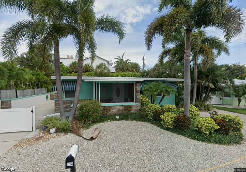
114 81st St Holmes Beach, FL 34217
Estimated Value: $1,314,368 - $1,734,000
3
Beds
2
Baths
1,976
Sq Ft
$792/Sq Ft
Est. Value
About This Home
This home is located at 114 81st St, Holmes Beach, FL 34217 and is currently estimated at $1,565,592, approximately $792 per square foot. 114 81st St is a home located in Manatee County with nearby schools including Anna Maria Elementary School, Martha B. King Middle School, and Manatee High School.
Ownership History
Date
Name
Owned For
Owner Type
Purchase Details
Closed on
Jan 27, 2023
Sold by
Owen Thomas M and Owen Sheryl A
Bought by
114 81St Street Llc
Current Estimated Value
Purchase Details
Closed on
Mar 31, 2004
Sold by
Simmons Robert D and Simmons Cathryn E
Bought by
Owen Thomas M and Owen Sheryl A
Home Financials for this Owner
Home Financials are based on the most recent Mortgage that was taken out on this home.
Original Mortgage
$380,000
Interest Rate
3.37%
Mortgage Type
Purchase Money Mortgage
Purchase Details
Closed on
Oct 7, 1998
Sold by
Sumner Henry E and Sumner Winifred A
Bought by
Simmons Robert D and Simmons Cathryn E
Home Financials for this Owner
Home Financials are based on the most recent Mortgage that was taken out on this home.
Original Mortgage
$175,000
Interest Rate
6.95%
Create a Home Valuation Report for This Property
The Home Valuation Report is an in-depth analysis detailing your home's value as well as a comparison with similar homes in the area
Home Values in the Area
Average Home Value in this Area
Purchase History
We collect this data history from publicly available records. To have your information removed, we recommend requesting removal directly through your county’s website.
| Date | Buyer | Sale Price | Title Company |
|---|---|---|---|
| 114 81St Street Llc | $100 | -- | |
| Owen Thomas M | $475,000 | Barnes Walker Title Inc | |
| Simmons Robert D | $200,000 | -- |
Source: Public Records
Mortgage History
We collect this data history from publicly available records. To have your information removed, we recommend requesting removal directly through your county’s website.
| Date | Status | Borrower | Loan Amount |
|---|---|---|---|
| Previous Owner | Owen Thomas M | $380,000 | |
| Previous Owner | Simmons Robert D | $175,000 |
Source: Public Records
Tax History
| Year | Tax Paid | Tax Assessment Tax Assessment Total Assessment is a certain percentage of the fair market value that is determined by local assessors to be the total taxable value of land and additions on the property. | Land | Improvement |
|---|---|---|---|---|
| 2025 | $20,214 | $1,277,960 | $946,220 | $331,740 |
| 2023 | $16,030 | $1,334,929 | $946,220 | $388,709 |
| 2022 | $12,794 | $912,562 | $556,600 | $355,962 |
| 2021 | $10,580 | $659,297 | $475,640 | $183,657 |
| 2020 | $10,249 | $607,284 | $431,000 | $176,284 |
| 2019 | $10,274 | $607,284 | $431,000 | $176,284 |
| 2018 | $10,100 | $591,564 | $431,000 | $160,564 |
| 2017 | $9,178 | $571,396 | $0 | $0 |
| 2016 | $8,635 | $532,823 | $0 | $0 |
| 2015 | $7,024 | $515,054 | $0 | $0 |
| 2014 | $7,024 | $416,032 | $0 | $0 |
| 2013 | $6,912 | $403,915 | $266,500 | $137,415 |
Source: Public Records
Map
Nearby Homes
- 8106 Gulf Dr
- 8106 Gulf Dr Unit A&B
- 131 White Ave
- 117 81st St
- 103 Sunset Ln
- 412 80th St
- 414 79th St
- 213 83rd St Unit EAST Villa/Unit A
- 104 Sunset Ln
- 8010 Marina Dr
- 214 85th St
- 102 Sunset Ln
- 103 Park Ave
- 215 83rd St
- 204 75th St
- 221 85th St
- 107 Maple Ave
- 8301 Marina Dr Unit 8
- 213 75th St
- 207 75th St Unit B
- 8104 Gulf Dr
- 8106 Gulf Dr Unit A
- 8106 Gulf Dr Unit B
- 125 Neptune Ln
- 117 Lane
- 22 85th St
- 119 Neptune Ln
- 8108 Gulf Dr Unit A
- 116 81st St
- 133 White Ave
- 131 Avenue
- 131 White Ave Unit A
- 131 White Ave Unit A & B
- 119 81st St Unit A
- 8101 Palm Dr Unit 2
- 121 Neptune Ln
- 122 Neptune Ln
- 120 Neptune Ln
- 202 81st St
- 7902 Palm Dr Unit 1
Your Personal Tour Guide
Ask me questions while you tour the home.