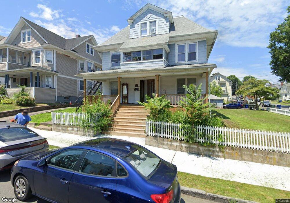
114 Bronx Ave Unit 116 Bridgeport, CT 06606
Brooklawn-Saint Vincent NeighborhoodEstimated Value: $407,575 - $848,000
6
Beds
3
Baths
4,137
Sq Ft
$146/Sq Ft
Est. Value
About This Home
This home is located at 114 Bronx Ave Unit 116, Bridgeport, CT 06606 and is currently estimated at $602,894, approximately $145 per square foot. 114 Bronx Ave Unit 116 is a home located in Fairfield County with nearby schools including Madison School, Central High School, and Catholic Academy of Bridgeport-St. Raphael Academy.
Ownership History
Date
Name
Owned For
Owner Type
Purchase Details
Closed on
May 12, 1997
Sold by
Durner Donald A and Durner Kathleen M
Bought by
Ruiz Angel N
Current Estimated Value
Home Financials for this Owner
Home Financials are based on the most recent Mortgage that was taken out on this home.
Original Mortgage
$121,450
Interest Rate
7.88%
Mortgage Type
Unknown
Create a Home Valuation Report for This Property
The Home Valuation Report is an in-depth analysis detailing your home's value as well as a comparison with similar homes in the area
Home Values in the Area
Average Home Value in this Area
Purchase History
| Date | Buyer | Sale Price | Title Company |
|---|---|---|---|
| Ruiz Angel N | $122,500 | -- | |
| Ruiz Angel N | $122,500 | -- |
Source: Public Records
Mortgage History
| Date | Status | Borrower | Loan Amount |
|---|---|---|---|
| Open | Ruiz Angel N | $236,060 | |
| Closed | Ruiz Angel N | $188,000 | |
| Closed | Ruiz Angel N | $145,000 | |
| Closed | Ruiz Angel N | $121,450 |
Source: Public Records
Tax History Compared to Growth
Tax History
| Year | Tax Paid | Tax Assessment Tax Assessment Total Assessment is a certain percentage of the fair market value that is determined by local assessors to be the total taxable value of land and additions on the property. | Land | Improvement |
|---|---|---|---|---|
| 2025 | $10,586 | $243,630 | $79,710 | $163,920 |
| 2024 | $10,586 | $243,630 | $79,710 | $163,920 |
| 2023 | $10,586 | $243,630 | $79,710 | $163,920 |
| 2022 | $10,586 | $243,630 | $79,710 | $163,920 |
| 2021 | $10,586 | $243,630 | $79,710 | $163,920 |
| 2020 | $9,797 | $181,460 | $44,950 | $136,510 |
| 2019 | $9,797 | $181,460 | $44,950 | $136,510 |
| 2018 | $9,866 | $181,460 | $44,950 | $136,510 |
| 2017 | $9,866 | $181,460 | $44,950 | $136,510 |
| 2016 | $9,866 | $181,460 | $44,950 | $136,510 |
| 2015 | $9,911 | $234,860 | $54,400 | $180,460 |
| 2014 | $9,911 | $234,860 | $54,400 | $180,460 |
Source: Public Records
Map
Nearby Homes
- 508 Hawley Ave
- 106 Manhattan Ave Unit 108
- 123 Harlem Ave
- 203 Wayne St
- 252 Harlem Ave Unit B6
- 252 Harlem Ave Unit B5
- 119 Madison Terrace
- 724 Capitol Ave Unit 726
- 936 Lindley St
- 330 French St
- 105 Tremont Ave Unit E
- 105 Tremont Ave Unit B
- 631 Fairview Ave
- 234 Savoy St
- 2395 Main St Unit 2397
- 390 Charles St Unit 106
- 241 Sampson St
- 926 Hart St
- 916 Hart St
- 485 Westfield Ave
- 126 Bronx Ave Unit 3
- 124 Bronx Ave Unit 126
- 124-126 Bronx
- 132 Bronx Ave Unit 134
- 142 Bronx Ave Unit 144
- 121 Bronx Ave Unit 123
- 121 Bronx Ave Unit 2ND
- 111 Bronx Ave Unit 113
- 131 Bronx Ave Unit 133
- 131 Bronx Ave Unit 2
- 196 Morningside Dr Unit 1
- 196 Morningside Dr Unit 198
- 196 Morningside Dr Unit 1st
- 27 Manhattan Ave Unit 2
- 35 Manhattan Ave
- 15 Manhattan Ave Unit 17
- 9 Manhattan Ave
- 96 Morningside Dr
- 116 Morningside Dr Unit 118
- 47 Manhattan Ave