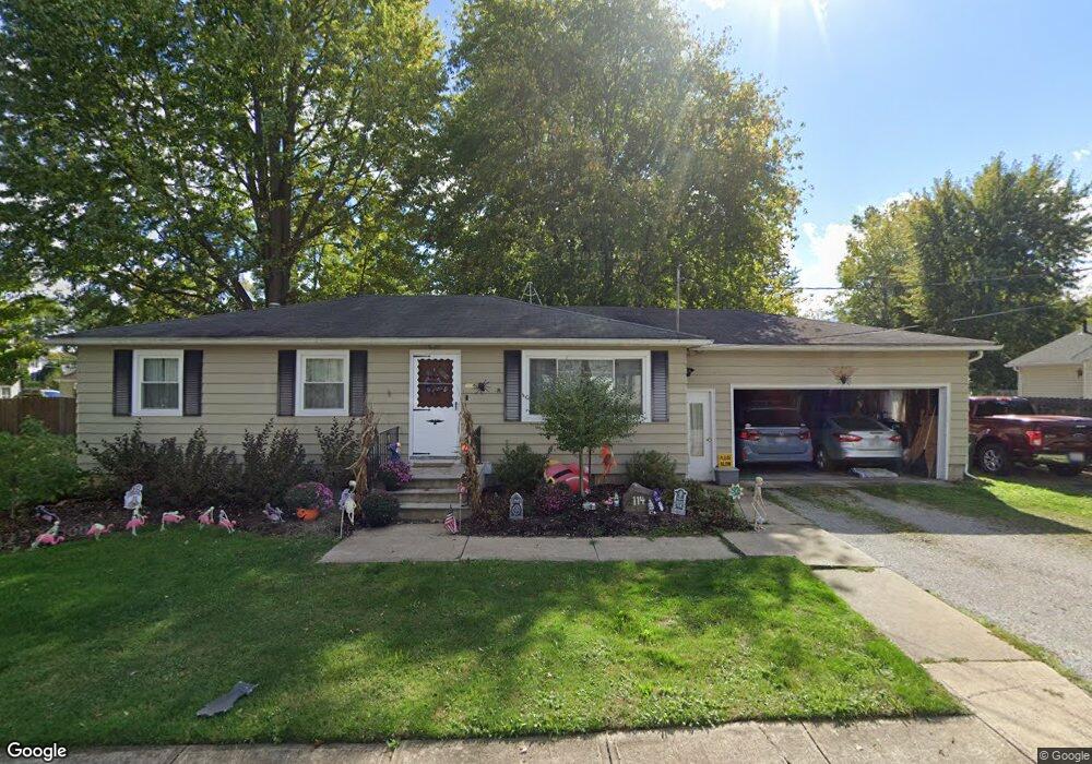
114 Forest St Lagrange, OH 44050
Estimated Value: $160,000 - $214,000
3
Beds
1
Bath
1,160
Sq Ft
$161/Sq Ft
Est. Value
About This Home
This home is located at 114 Forest St, Lagrange, OH 44050 and is currently estimated at $186,700, approximately $160 per square foot. 114 Forest St is a home located in Lorain County with nearby schools including Keystone Elementary School, Keystone Middle School, and Keystone High School.
Ownership History
Date
Name
Owned For
Owner Type
Purchase Details
Closed on
Sep 18, 2025
Sold by
St Peter Loren Woodruff
Bought by
St Peter Loren and St Peter Michael V
Current Estimated Value
Purchase Details
Closed on
Jun 6, 2023
Sold by
Woodruff Lawrence S
Bought by
St Peter Loren Woodruff
Purchase Details
Closed on
Dec 11, 2009
Sold by
Woodruff Larry S and Woodruff Elletra L
Bought by
Woodruff Larry S and Woodruff Elletra L
Purchase Details
Closed on
Aug 22, 2003
Sold by
Schacht Ralph L and Schacht Elletra M
Bought by
Schacht Ralph L and Schacht Elletra M
Purchase Details
Closed on
May 29, 1997
Sold by
Bullard Franklin C
Bought by
Schacht Ralph L and Schacht Elletra M
Create a Home Valuation Report for This Property
The Home Valuation Report is an in-depth analysis detailing your home's value as well as a comparison with similar homes in the area
Home Values in the Area
Average Home Value in this Area
Purchase History
| Date | Buyer | Sale Price | Title Company |
|---|---|---|---|
| St Peter Loren | -- | None Listed On Document | |
| St Peter Loren Woodruff | -- | None Listed On Document | |
| Woodruff Larry S | -- | Attorney | |
| Schacht Ralph L | -- | -- | |
| Schacht Ralph L | $90,000 | -- |
Source: Public Records
Tax History
| Year | Tax Paid | Tax Assessment Tax Assessment Total Assessment is a certain percentage of the fair market value that is determined by local assessors to be the total taxable value of land and additions on the property. | Land | Improvement |
|---|---|---|---|---|
| 2024 | $2,101 | $49,560 | $8,922 | $40,639 |
| 2023 | $2,079 | $40,170 | $9,569 | $30,601 |
| 2022 | $2,065 | $40,170 | $9,569 | $30,601 |
| 2021 | $2,066 | $40,170 | $9,570 | $30,600 |
| 2020 | $1,885 | $32,660 | $7,780 | $24,880 |
| 2019 | $1,874 | $32,660 | $7,780 | $24,880 |
| 2018 | $1,814 | $32,660 | $7,780 | $24,880 |
| 2017 | $1,965 | $33,130 | $5,700 | $27,430 |
| 2016 | $1,954 | $33,130 | $5,700 | $27,430 |
| 2015 | $1,951 | $33,130 | $5,700 | $27,430 |
| 2014 | $1,516 | $29,060 | $5,000 | $24,060 |
| 2013 | $1,472 | $29,060 | $5,000 | $24,060 |
Source: Public Records
Map
Nearby Homes
- 516 Appomattox Ct
- 548 William St
- 305 W Main St
- 608 Rundle St
- 110 Railroad St
- 700 Hayes St
- 336 Granger Dr
- 808 Buckingham Dr
- 800 Buckingham Dr
- 801 Willich Ct
- 613 U s Grant St
- 17327 Wheeler Rd
- 0 Whitehead Rd
- 18022 State Route 301
- 40260 Whitney Rd
- 14768 Whitehead Rd
- 42113 Meadow Ln
- 704 Black Bear Run
- 40175 Banks Rd
- 17058 Chamberlain Rd
Your Personal Tour Guide
Ask me questions while you tour the home.