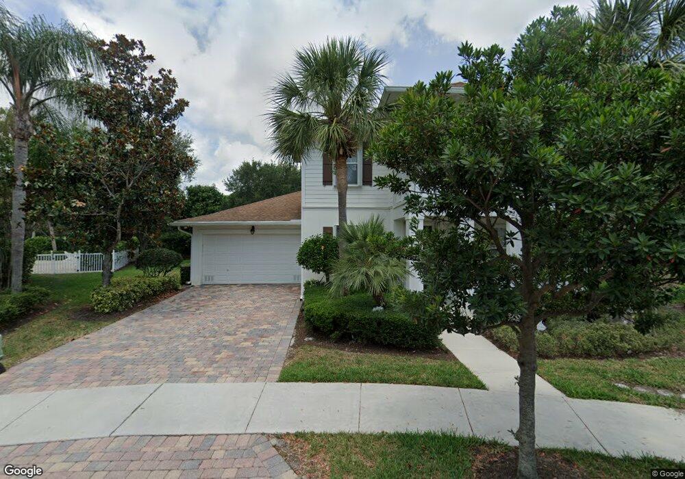
114 Lagrange Way Jupiter, FL 33458
Abacoa NeighborhoodEstimated Value: $1,317,772 - $1,388,000
5
Beds
4
Baths
2,918
Sq Ft
$459/Sq Ft
Est. Value
About This Home
This home is located at 114 Lagrange Way, Jupiter, FL 33458 and is currently estimated at $1,339,193, approximately $458 per square foot. 114 Lagrange Way is a home located in Palm Beach County with nearby schools including Lighthouse Elementary School, William T. Dwyer High School, and Beacon Cove Intermediate School.
Ownership History
Date
Name
Owned For
Owner Type
Purchase Details
Closed on
Mar 15, 2006
Sold by
Divosta Homes Lp
Bought by
Saxena Vinay R
Current Estimated Value
Home Financials for this Owner
Home Financials are based on the most recent Mortgage that was taken out on this home.
Original Mortgage
$649,700
Outstanding Balance
$353,848
Interest Rate
5.75%
Mortgage Type
Fannie Mae Freddie Mac
Estimated Equity
$985,345
Create a Home Valuation Report for This Property
The Home Valuation Report is an in-depth analysis detailing your home's value as well as a comparison with similar homes in the area
Home Values in the Area
Average Home Value in this Area
Purchase History
| Date | Buyer | Sale Price | Title Company |
|---|---|---|---|
| Saxena Vinay R | $649,700 | American Title Of The Palm B |
Source: Public Records
Mortgage History
| Date | Status | Borrower | Loan Amount |
|---|---|---|---|
| Open | Saxena Vinay R | $649,700 |
Source: Public Records
Tax History
| Year | Tax Paid | Tax Assessment Tax Assessment Total Assessment is a certain percentage of the fair market value that is determined by local assessors to be the total taxable value of land and additions on the property. | Land | Improvement |
|---|---|---|---|---|
| 2025 | $10,289 | $489,054 | -- | -- |
| 2024 | $10,289 | $475,271 | -- | -- |
| 2023 | $10,063 | $461,428 | $0 | $0 |
| 2022 | $9,966 | $447,988 | $0 | $0 |
| 2021 | $9,739 | $434,940 | $0 | $0 |
| 2020 | $9,633 | $428,935 | $0 | $0 |
| 2019 | $9,555 | $419,291 | $0 | $0 |
| 2018 | $9,150 | $411,473 | $0 | $0 |
| 2017 | $9,149 | $403,010 | $0 | $0 |
| 2016 | $9,117 | $394,721 | $0 | $0 |
| 2015 | $9,291 | $391,977 | $0 | $0 |
| 2014 | $9,449 | $388,866 | $0 | $0 |
Source: Public Records
Map
Nearby Homes
- 102 Bonaire Ln
- 1019 Egret Cir N
- 220 Blackbird Ln
- 1703 W Community Dr
- 3032 W Community Dr
- 190 S Hampton Dr
- 205 Brier Cir
- 151 St Michaels Ct
- 231 Sparrow Point
- 141 St Michaels Ct
- 6031 Robinson St
- 236 Sparrow Point
- 262 Brier Cir Unit 128
- 227 Caravelle Dr
- 6085 Robinson St
- 224 Locha Dr
- 1358 Community Dr
- 194 Locha Dr
- 176 Bent Arrow Dr
- 110 Florence Dr
- 110 Lagrange Way
- 115 Lagrange Way
- 106 Lagrange Way
- 111 Lagrange Way
- 107 Lagrange Way
- 102 Lagrange Way
- 103 Lagrange Way
- 610 Scrubjay Dr
- 409 Caravelle Dr
- 413 Caravelle Dr
- 612 Scrubjay Dr
- 362 Caravelle Dr
- 608 Scrubjay Dr
- 405 Caravelle Dr
- 401 Caravelle Dr
- 417 Caravelle Dr
- 606 Scrubjay Dr
- 358 Caravelle Dr
- 611 Scrubjay Dr
- 421 Caravelle Dr
Your Personal Tour Guide
Ask me questions while you tour the home.