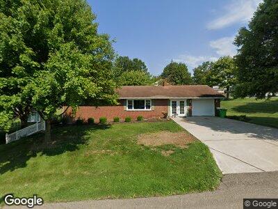
114 Ronsan St SW Sugarcreek, OH 44681
Estimated Value: $243,000 - $293,000
2
Beds
1
Bath
1,484
Sq Ft
$177/Sq Ft
Est. Value
About This Home
This home is located at 114 Ronsan St SW, Sugarcreek, OH 44681 and is currently estimated at $262,049, approximately $176 per square foot. 114 Ronsan St SW is a home located in Tuscarawas County with nearby schools including Garaway High School, Genza Bottom, and OAK RIDGE SCHOOL.
Ownership History
Date
Name
Owned For
Owner Type
Purchase Details
Closed on
Jan 11, 2021
Sold by
Mast Marilyn L and Frutig Cindy Lou
Bought by
Beachy Daniel I
Current Estimated Value
Home Financials for this Owner
Home Financials are based on the most recent Mortgage that was taken out on this home.
Original Mortgage
$165,000
Outstanding Balance
$148,916
Interest Rate
2.7%
Mortgage Type
New Conventional
Estimated Equity
$113,133
Purchase Details
Closed on
Oct 29, 1990
Sold by
Mcgovern Myrtle M
Bought by
Mast Marilyn L
Create a Home Valuation Report for This Property
The Home Valuation Report is an in-depth analysis detailing your home's value as well as a comparison with similar homes in the area
Home Values in the Area
Average Home Value in this Area
Purchase History
| Date | Buyer | Sale Price | Title Company |
|---|---|---|---|
| Beachy Daniel I | $185,000 | Alban Title | |
| Mast Marilyn L | $72,000 | -- |
Source: Public Records
Mortgage History
| Date | Status | Borrower | Loan Amount |
|---|---|---|---|
| Open | Beachy Daniel I | $165,000 |
Source: Public Records
Tax History Compared to Growth
Tax History
| Year | Tax Paid | Tax Assessment Tax Assessment Total Assessment is a certain percentage of the fair market value that is determined by local assessors to be the total taxable value of land and additions on the property. | Land | Improvement |
|---|---|---|---|---|
| 2024 | $2,804 | $205,500 | $67,740 | $137,760 |
| 2023 | $2,804 | $205,500 | $67,740 | $137,760 |
| 2022 | $2,826 | $71,925 | $23,709 | $48,216 |
| 2021 | $2,178 | $60,806 | $23,415 | $37,391 |
| 2020 | $2,184 | $60,806 | $23,415 | $37,391 |
| 2019 | $2,195 | $60,806 | $23,415 | $37,391 |
| 2018 | $1,709 | $51,310 | $19,760 | $31,550 |
| 2017 | $1,709 | $51,310 | $19,760 | $31,550 |
| 2016 | $1,712 | $51,310 | $19,760 | $31,550 |
| 2014 | $1,601 | $48,160 | $18,410 | $29,750 |
| 2013 | $1,493 | $48,160 | $18,410 | $29,750 |
Source: Public Records
Map
Nearby Homes
- 232 Church St SW
- 221 5th St SW
- 131 Maple St SW
- 0 Cherry Ridge Dr SW Unit 5106181
- 163 Heritage Crossing SE
- 9659 Yoder Rd SW
- 0 Yoder Rd SW
- 0 Winklepleck Rd NW
- 186 Pleasant Valley Rd SW
- 3004 Winklepleck Rd NW
- 3860 Township Road 162
- 3850 Township Road 162
- 5467 Old Route 39 NW
- 4991 Walnut St
- 3153 Boltz Orchard Rd SW
- 127 Buena Vista St
- 125 Buena Vista St
- 121 Buena Vista St
- 4333 Broad Run Dairy Rd NW
- 0 Hilltop Rd Unit 5119979
- 114 Ronsan St SW
- 124 Ronsan St SW
- 115 Ronsan St SW
- 610 W Main St
- 726 W Main St
- 708 Beechy Dr SW
- 125 Ronsan St SW
- 703 W Main St
- 713 W Main St
- 723 W Main St
- 135 Ronsan St SW
- 136 Ronsan St SW
- 734 W Main St
- 733 W Main St
- 604 W Main St
- 124 Church St SW
- 143 Ronsan St SW
- 144 Ronsan St SW
- 744 W Main St
- 743 W Main St