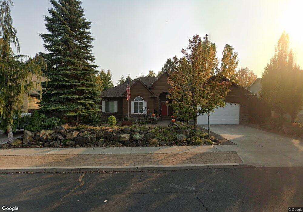
114 SE Airpark Dr Bend, OR 97702
Larkspur NeighborhoodEstimated Value: $701,274 - $755,000
4
Beds
2
Baths
2,122
Sq Ft
$340/Sq Ft
Est. Value
About This Home
This home is located at 114 SE Airpark Dr, Bend, OR 97702 and is currently estimated at $721,319, approximately $339 per square foot. 114 SE Airpark Dr is a home located in Deschutes County with nearby schools including Bear Creek Elementary School, Bend Senior High School, and Eastmont Community School.
Ownership History
Date
Name
Owned For
Owner Type
Purchase Details
Closed on
Mar 25, 2009
Sold by
Curtis Austin H
Bought by
Curtis Austin H and Austin & Elizabeth Curtis Trust
Current Estimated Value
Home Financials for this Owner
Home Financials are based on the most recent Mortgage that was taken out on this home.
Original Mortgage
$281,000
Outstanding Balance
$178,101
Interest Rate
5.15%
Mortgage Type
New Conventional
Estimated Equity
$543,218
Purchase Details
Closed on
Dec 27, 2006
Sold by
Curtis Austin H
Bought by
Curtis Austin H and Austin & Elizabeth Curtis Trust
Purchase Details
Closed on
Jul 7, 2006
Sold by
Delange David A and Delange Michelle
Bought by
Curtis Austin H
Home Financials for this Owner
Home Financials are based on the most recent Mortgage that was taken out on this home.
Original Mortgage
$279,900
Interest Rate
6.66%
Mortgage Type
Unknown
Create a Home Valuation Report for This Property
The Home Valuation Report is an in-depth analysis detailing your home's value as well as a comparison with similar homes in the area
Home Values in the Area
Average Home Value in this Area
Purchase History
| Date | Buyer | Sale Price | Title Company |
|---|---|---|---|
| Curtis Austin H | -- | Accommodation | |
| Curtis Austin H | -- | Amerititle | |
| Curtis Austin H | -- | None Available | |
| Curtis Austin H | $429,900 | Western Title & Escrow Co |
Source: Public Records
Mortgage History
| Date | Status | Borrower | Loan Amount |
|---|---|---|---|
| Open | Curtis Austin H | $281,000 | |
| Previous Owner | Curtis Austin H | $279,900 |
Source: Public Records
Tax History Compared to Growth
Tax History
| Year | Tax Paid | Tax Assessment Tax Assessment Total Assessment is a certain percentage of the fair market value that is determined by local assessors to be the total taxable value of land and additions on the property. | Land | Improvement |
|---|---|---|---|---|
| 2025 | $5,511 | $326,170 | -- | -- |
| 2024 | $5,302 | $316,670 | -- | -- |
| 2023 | $4,915 | $307,450 | $0 | $0 |
| 2022 | $4,586 | $289,810 | $0 | $0 |
| 2021 | $4,593 | $281,370 | $0 | $0 |
| 2020 | $4,357 | $281,370 | $0 | $0 |
| 2019 | $4,236 | $273,180 | $0 | $0 |
| 2018 | $4,116 | $265,230 | $0 | $0 |
| 2017 | $3,863 | $248,970 | $0 | $0 |
| 2016 | $3,684 | $241,720 | $0 | $0 |
| 2015 | $3,582 | $234,680 | $0 | $0 |
| 2014 | $3,477 | $227,850 | $0 | $0 |
Source: Public Records
Map
Nearby Homes
- 61635 Pettigrew Rd Unit 12
- 61807 SE Rolo Ct
- 61839 Avonlea Cir
- 20960 Gardenia Ave
- 61847 SE 27th St
- 61839 SE 27th St
- 21035 Clairaway Ave
- 61730 Joan Ct
- 21154 Ritz Place
- 61969 SE 27th St
- 62001 NE Nates Place
- 21177 Ritz Place
- 21176 Desert Skies Place
- 62025 NE Nate's Place
- 61683 Daly Estates Dr
- 21019 Carl St
- 98 NE Telima Ln
- 21283 Dove Ln
- 61635 Daly Estates Dr Unit 17
- 61620 Daly Estates Dr
- 110 SE Airpark Dr
- 118 SE Airpark Dr
- 111 SE Airpark Dr
- 106 SE Airpark Dr
- 122 SE Airpark Dr
- 115 SE Airpark Dr
- 21070 Thomas Dr
- 391 SE Case Dr
- 104 SE Airpark Dr
- 126 SE Airpark Dr
- 21062 Thomas Dr
- 105 SE Airpark Dr
- 127 SE Airpark Dr
- 101 SE Airpark Dr
- 130 SE Airpark Dr
- 100 SE Airpark Dr
- 392 SE Case Dr
- 21086 Thomas Dr