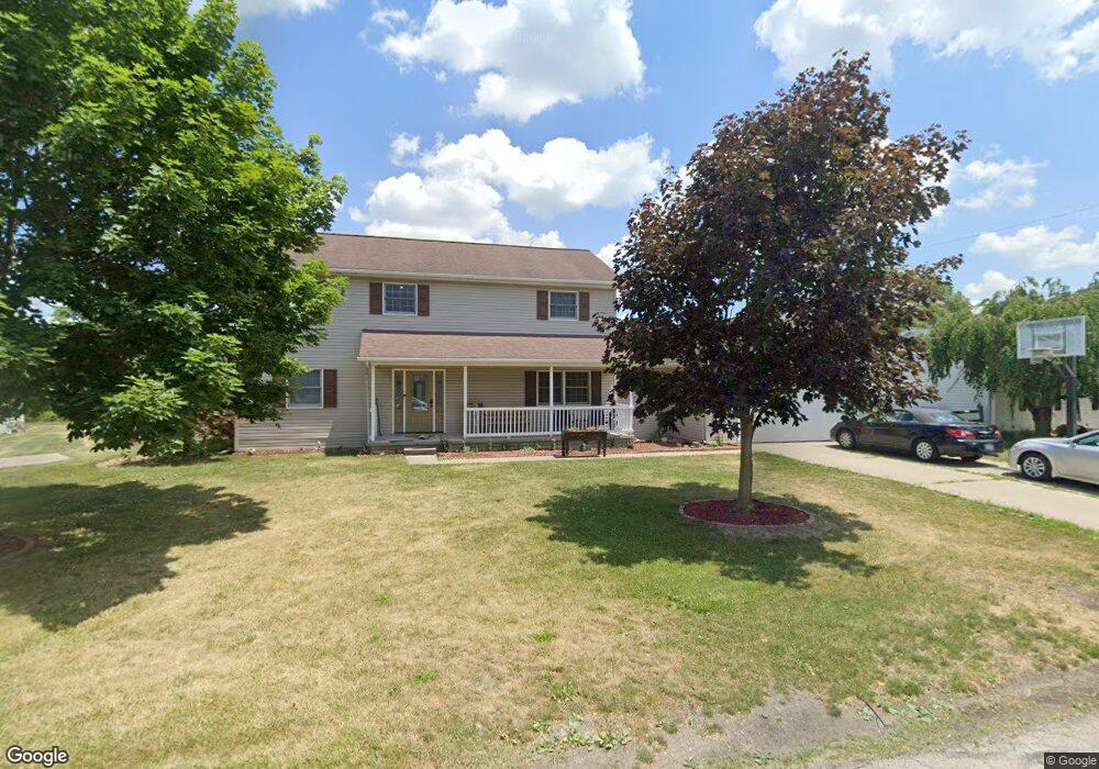
1140 Royal Bounty Ln Wauseon, OH 43567
Estimated Value: $308,000 - $414,000
4
Beds
3
Baths
2,264
Sq Ft
$159/Sq Ft
Est. Value
About This Home
This home is located at 1140 Royal Bounty Ln, Wauseon, OH 43567 and is currently estimated at $360,274, approximately $159 per square foot. 1140 Royal Bounty Ln is a home located in Fulton County with nearby schools including Wauseon Primary School, Wauseon Elementary School, and Wauseon Middle School.
Ownership History
Date
Name
Owned For
Owner Type
Purchase Details
Closed on
Apr 30, 2010
Sold by
Suntken Chad L and Suntken Laurie K
Bought by
Pratt Theresa A
Current Estimated Value
Home Financials for this Owner
Home Financials are based on the most recent Mortgage that was taken out on this home.
Original Mortgage
$138,000
Outstanding Balance
$92,496
Interest Rate
5.05%
Mortgage Type
New Conventional
Estimated Equity
$267,778
Purchase Details
Closed on
Jan 1, 1990
Bought by
Jacobs Lillian C
Create a Home Valuation Report for This Property
The Home Valuation Report is an in-depth analysis detailing your home's value as well as a comparison with similar homes in the area
Home Values in the Area
Average Home Value in this Area
Purchase History
| Date | Buyer | Sale Price | Title Company |
|---|---|---|---|
| Pratt Theresa A | $172,500 | Attorney | |
| Jacobs Lillian C | -- | -- |
Source: Public Records
Mortgage History
| Date | Status | Borrower | Loan Amount |
|---|---|---|---|
| Open | Pratt Theresa A | $138,000 |
Source: Public Records
Tax History Compared to Growth
Tax History
| Year | Tax Paid | Tax Assessment Tax Assessment Total Assessment is a certain percentage of the fair market value that is determined by local assessors to be the total taxable value of land and additions on the property. | Land | Improvement |
|---|---|---|---|---|
| 2024 | $4,912 | $98,850 | $10,260 | $88,590 |
| 2023 | $4,912 | $98,850 | $10,260 | $88,590 |
| 2022 | $4,197 | $71,820 | $8,540 | $63,280 |
| 2021 | $4,403 | $71,820 | $8,540 | $63,280 |
| 2020 | $4,117 | $71,820 | $8,540 | $63,280 |
| 2019 | $4,059 | $69,760 | $9,100 | $60,660 |
| 2018 | $3,731 | $69,760 | $9,100 | $60,660 |
| 2017 | $3,681 | $69,760 | $9,100 | $60,660 |
| 2016 | $3,775 | $66,850 | $9,100 | $57,750 |
| 2015 | $3,545 | $66,850 | $9,100 | $57,750 |
| 2014 | $3,532 | $66,850 | $9,100 | $57,750 |
| 2013 | $3,146 | $54,960 | $7,740 | $47,220 |
Source: Public Records
Map
Nearby Homes
- 801 N Shoop Ave
- 351 E Walnut St
- 227 Wabash St
- 1270 S Park Ln
- 204 Jefferson St
- 460 Airport Hwy
- 217 Marshall St
- 527 E Elm St
- 1338 N Park Ln
- 428 N Brunell St
- 524 E Elm St
- 139 Marshall St
- 1209 Apache Dr
- 14578 Us Highway 20a
- Integrity 1830 Plan at Arrowhead Trails
- integrity 2280 Plan at Arrowhead Trails
- Integrity 2080 Plan at Arrowhead Trails
- 1062 Seneca Dr
- 1066 Seneca Dr
- 1058 Seneca Dr
- 1130 Royal Bounty Ln
- 1150 Royal Bounty Ln
- 310 Royal Bounty Ln
- 335 Royal Bounty Ln
- 1120 Royal Bounty Ln
- 1125 Royal Bounty Ln
- 325 Royal Bounty Ln
- 1110 Royal Bounty Ln
- 315 Royal Bounty Ln
- 300 Royal Bounty Ln
- 1130 Old Orchard Dr
- 1120 Old Orchard Dr
- 305 Royal Bounty Ln
- 1110 Old Orchard Dr
- 340 Cole St
- 320 Cole St
- 1040 Old Orchard Dr
- 1135 Old Orchard Dr
- 1125 Old Orchard Dr
- 1103 Old Orchard Dr