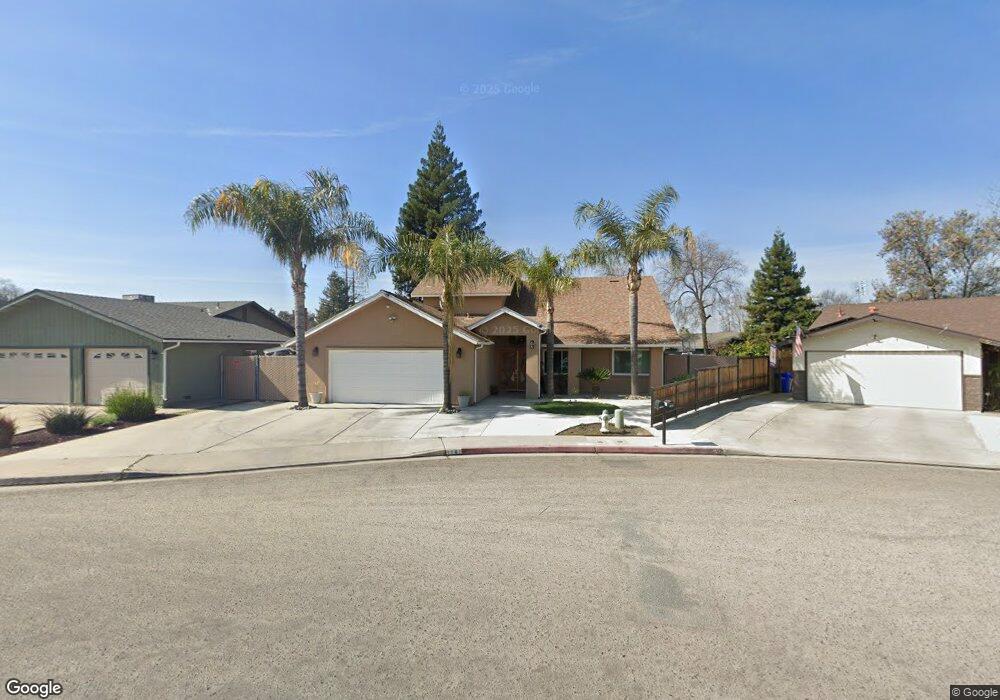
1141 Birch Dr Porterville, CA 93257
Porterville Northwest NeighborhoodEstimated Value: $353,000 - $394,000
3
Beds
2
Baths
2,172
Sq Ft
$173/Sq Ft
Est. Value
About This Home
This home is located at 1141 Birch Dr, Porterville, CA 93257 and is currently estimated at $375,411, approximately $172 per square foot. 1141 Birch Dr is a home located in Tulare County with nearby schools including Oak Grove Elementary School, Burton Middle School, and Monache High School.
Ownership History
Date
Name
Owned For
Owner Type
Purchase Details
Closed on
Dec 17, 2025
Sold by
Singh Avtar and Devi Fnu Kiran
Bought by
Singh Avtar and Devi Fnu Kiran
Current Estimated Value
Home Financials for this Owner
Home Financials are based on the most recent Mortgage that was taken out on this home.
Original Mortgage
$337,600
Outstanding Balance
$333,518
Interest Rate
6.22%
Mortgage Type
New Conventional
Estimated Equity
$41,893
Purchase Details
Closed on
Dec 7, 1999
Sold by
Dunn Juanita
Bought by
Singh Avta
Purchase Details
Closed on
Jun 30, 1994
Sold by
Kaur Lakhinder
Bought by
Singh Avtar
Purchase Details
Closed on
Jan 4, 1994
Sold by
Dunn Juanita
Bought by
Dunn Juanita
Home Financials for this Owner
Home Financials are based on the most recent Mortgage that was taken out on this home.
Original Mortgage
$70,000
Interest Rate
7.38%
Mortgage Type
Purchase Money Mortgage
Create a Home Valuation Report for This Property
The Home Valuation Report is an in-depth analysis detailing your home's value as well as a comparison with similar homes in the area
Home Values in the Area
Average Home Value in this Area
Purchase History
| Date | Buyer | Sale Price | Title Company |
|---|---|---|---|
| Singh Avtar | -- | Stewart Title Of California | |
| Singh Avta | $65,000 | -- | |
| Singh Avtar | -- | -- | |
| Dunn Juanita | -- | First American Title Ins Co |
Source: Public Records
Mortgage History
| Date | Status | Borrower | Loan Amount |
|---|---|---|---|
| Open | Singh Avtar | $337,600 | |
| Previous Owner | Dunn Juanita | $70,000 |
Source: Public Records
Tax History
| Year | Tax Paid | Tax Assessment Tax Assessment Total Assessment is a certain percentage of the fair market value that is determined by local assessors to be the total taxable value of land and additions on the property. | Land | Improvement |
|---|---|---|---|---|
| 2025 | $1,453 | $138,328 | $38,424 | $99,904 |
| 2024 | $1,453 | $135,617 | $37,671 | $97,946 |
| 2023 | $1,457 | $132,959 | $36,933 | $96,026 |
| 2022 | $1,375 | $130,353 | $36,209 | $94,144 |
| 2021 | $1,380 | $127,797 | $35,499 | $92,298 |
| 2020 | $1,354 | $126,487 | $35,135 | $91,352 |
| 2019 | $1,354 | $124,007 | $34,446 | $89,561 |
| 2018 | $1,294 | $121,576 | $33,771 | $87,805 |
| 2017 | $1,273 | $119,192 | $33,109 | $86,083 |
| 2016 | $1,213 | $116,855 | $32,460 | $84,395 |
| 2015 | $1,170 | $115,099 | $31,972 | $83,127 |
| 2014 | $1,170 | $112,845 | $31,346 | $81,499 |
Source: Public Records
Map
Nearby Homes
- 1041 Greenfield Dr
- 1304 N Birch St
- 1865 W Wall Ave
- 1865 La Vida Ave
- 1350 N Lindale Way
- 1440 San Lucia Ave
- 1076 N Beverly St
- 1852 Santa Maria Ave
- 2273 W Santa Maria Ct Unit Lw179
- 2222 Santa Maria Ave Unit Lw187
- 2232 Santa Maria Ave Unit Lw188
- 2242 W Santa Maria Ct Unit Lw189
- 2212 Santa Maria Ave Unit Lw186
- 2266 W Santa Maria Ct Unit Lw191
- 1450 W Brian Ln
- 1306 Lowery St
- 1253 W Jean Ave
- 2164 W San Lucia Ct
- 635 N Belmont St
- 1209 Pioneer Ave
- 1151 Birch Dr
- 1151 Birch Dr
- 1131 Birch Dr
- 1150 N Patsy Dr
- 1140 N Patsy Dr
- 1160 N Patsy Dr
- 1700 W Wall Ln
- 1700 Wall Ln
- 1691 Wall Ln
- 1691 W Wall Ln
- 1121 Birch Dr
- 1130 N Patsy Dr
- 1170 N Patsy Dr
- 1690 W Wall Ln
- 1120 Birch Dr
- 1681 W Wall Ln
- 1681 Wall Ln
- 1711 W Westfield Ave
- 1120 N Patsy Dr
- 1721 W Westfield Ave
Your Personal Tour Guide
Ask me questions while you tour the home.