M
Seller's Agent in 2025
Mitch Coluzzi
Real Broker, LLC
(515) 518-1111
3 in this area
150 Total Sales
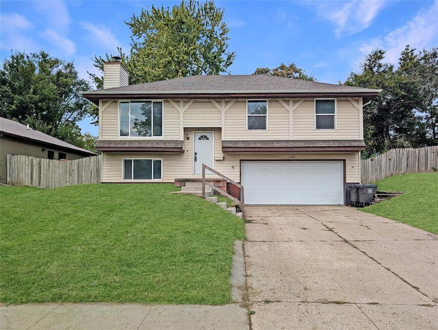


This 3-bedroom split-foyer is prepped and ready for its next chapter. Most of the heavy lifting is done — with new drywall throughout much of the home and updated mechanicals by the prior owner. The layout features one full bath on the main level, a cozy fireplace and rec room downstairs, plus a lower-level half bath and an additional room with egress. Outside, you’ll find a two-car tuck-under garage and just a few exterior updates left to bring this one across the finish line. A great project with strong resale potential in a convenient location!
| Date | Type | Sale Price | Title Company |
|---|---|---|---|
| Warranty Deed | $141,000 | None Listed On Document | |
| Warranty Deed | $82,000 | None Listed On Document | |
| Quit Claim Deed | -- | None Available | |
| Warranty Deed | $90,000 | First American Mortgage Sln | |
| Corporate Deed | $75,500 | -- | |
| Warranty Deed | -- | -- |
| Date | Status | Loan Amount | Loan Type |
|---|---|---|---|
| Open | $142,000 | Construction | |
| Previous Owner | $72,954 | FHA | |
| Previous Owner | $75,850 | FHA |
| Date | Event | Price | List to Sale | Price per Sq Ft |
|---|---|---|---|---|
| 10/31/2025 10/31/25 | Sold | $141,000 | +8.5% | $127 / Sq Ft |
| 10/17/2025 10/17/25 | Pending | -- | -- | -- |
| 10/16/2025 10/16/25 | For Sale | $129,900 | -- | $117 / Sq Ft |
| Year | Tax Paid | Tax Assessment Tax Assessment Total Assessment is a certain percentage of the fair market value that is determined by local assessors to be the total taxable value of land and additions on the property. | Land | Improvement |
|---|---|---|---|---|
| 2025 | $2,736 | $160,100 | $15,300 | $144,800 |
| 2024 | $2,736 | $139,100 | $13,100 | $126,000 |
| 2023 | $2,400 | $139,100 | $13,100 | $126,000 |
| 2022 | $2,380 | $101,800 | $10,000 | $91,800 |
| 2021 | $2,258 | $101,800 | $10,000 | $91,800 |
| 2020 | $2,346 | $90,500 | $8,900 | $81,600 |
| 2019 | $2,228 | $90,500 | $8,900 | $81,600 |
| 2018 | $2,206 | $82,900 | $7,900 | $75,000 |
| 2017 | $2,270 | $82,900 | $7,900 | $75,000 |
| 2016 | $2,210 | $83,900 | $7,900 | $76,000 |
| 2015 | $2,210 | $83,900 | $7,900 | $76,000 |
| 2014 | $1,964 | $73,900 | $7,600 | $66,300 |
M
Seller's Agent in 2025
Mitch Coluzzi
Real Broker, LLC
(515) 518-1111
3 in this area
150 Total Sales

Buyer's Agent in 2025
Celeste Rose
Real Broker, LLC
(515) 516-0105
2 in this area
29 Total Sales
Source: Des Moines Area Association of REALTORS®
MLS Number: 728461
APN: 030-01695013000
Disclaimer: Certain information contained herein is derived from information provided by parties other than Homes.com. All information provided is deemed reliable, but is not guaranteed to be accurate and should be independently verified.
![]() IDX information is provided exclusively for personal, non-commercial use, and may not be used for any purpose other than to identify prospective properties consumers may be interested in purchasing. Information is deemed reliable but not guaranteed.
IDX information is provided exclusively for personal, non-commercial use, and may not be used for any purpose other than to identify prospective properties consumers may be interested in purchasing. Information is deemed reliable but not guaranteed.