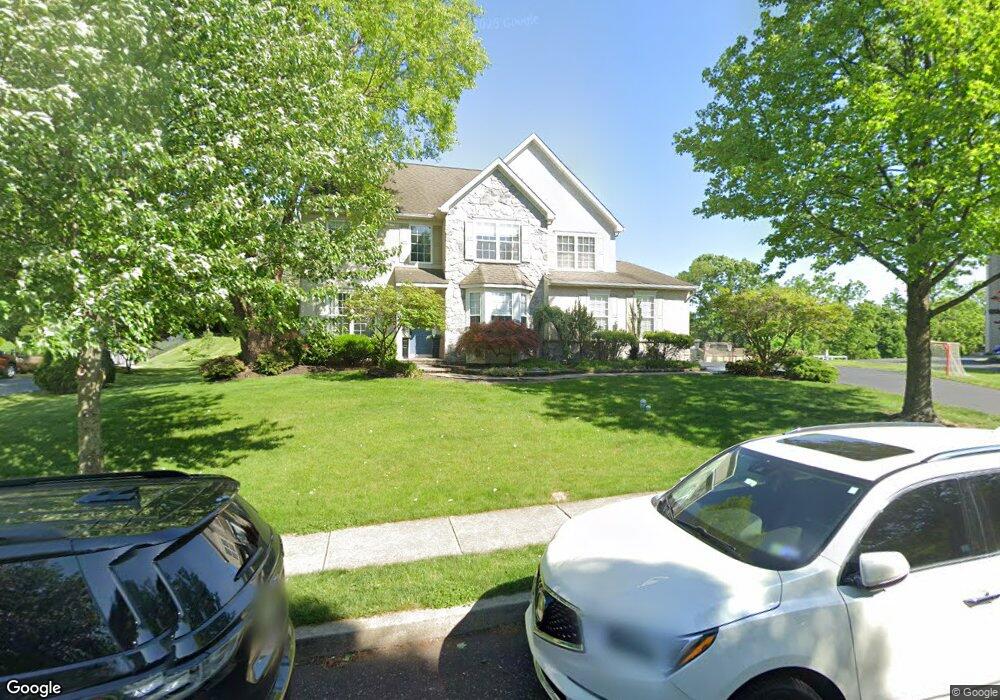
1142 Wendler Cir Pottstown, PA 19465
North Coventry NeighborhoodEstimated Value: $577,731 - $671,000
4
Beds
3
Baths
2,486
Sq Ft
$251/Sq Ft
Est. Value
About This Home
This home is located at 1142 Wendler Cir, Pottstown, PA 19465 and is currently estimated at $622,933, approximately $250 per square foot. 1142 Wendler Cir is a home located in Chester County with nearby schools including North Coventry Elementary School, Owen J Roberts Middle School, and Owen J Roberts High School.
Ownership History
Date
Name
Owned For
Owner Type
Purchase Details
Closed on
Aug 29, 2008
Sold by
Karpinski John D and Karpinski Mary Alice
Bought by
Costello Keith M and Costello Christa M
Current Estimated Value
Home Financials for this Owner
Home Financials are based on the most recent Mortgage that was taken out on this home.
Original Mortgage
$300,000
Outstanding Balance
$201,158
Interest Rate
6.69%
Mortgage Type
Purchase Money Mortgage
Estimated Equity
$421,775
Purchase Details
Closed on
Mar 1, 2000
Sold by
Martin Farm Associates Lp
Bought by
Karpinski John D and Karpinski Mary Alice
Home Financials for this Owner
Home Financials are based on the most recent Mortgage that was taken out on this home.
Original Mortgage
$203,000
Interest Rate
8.3%
Mortgage Type
VA
Create a Home Valuation Report for This Property
The Home Valuation Report is an in-depth analysis detailing your home's value as well as a comparison with similar homes in the area
Home Values in the Area
Average Home Value in this Area
Purchase History
| Date | Buyer | Sale Price | Title Company |
|---|---|---|---|
| Costello Keith M | $375,000 | None Available | |
| Karpinski John D | $215,769 | -- |
Source: Public Records
Mortgage History
| Date | Status | Borrower | Loan Amount |
|---|---|---|---|
| Open | Costello Keith M | $300,000 | |
| Previous Owner | Karpinski John D | $203,000 |
Source: Public Records
Tax History Compared to Growth
Tax History
| Year | Tax Paid | Tax Assessment Tax Assessment Total Assessment is a certain percentage of the fair market value that is determined by local assessors to be the total taxable value of land and additions on the property. | Land | Improvement |
|---|---|---|---|---|
| 2025 | $7,301 | $172,380 | $53,110 | $119,270 |
| 2024 | $7,301 | $172,380 | $53,110 | $119,270 |
| 2023 | $6,776 | $162,250 | $53,110 | $109,140 |
| 2022 | $6,636 | $162,250 | $53,110 | $109,140 |
| 2021 | $6,520 | $162,250 | $53,110 | $109,140 |
| 2020 | $6,356 | $162,250 | $53,110 | $109,140 |
| 2019 | $6,239 | $162,250 | $53,110 | $109,140 |
| 2018 | $6,072 | $162,250 | $53,110 | $109,140 |
| 2017 | $5,914 | $162,250 | $53,110 | $109,140 |
| 2016 | $6,169 | $162,250 | $53,110 | $109,140 |
| 2015 | $6,169 | $162,250 | $53,110 | $109,140 |
| 2014 | $6,169 | $162,250 | $53,110 | $109,140 |
Source: Public Records
Map
Nearby Homes
- 780 E Cedarville Rd
- 383 W Cedarville Rd
- 84 W Schuylkill Rd
- 614 Kline Ave
- 446 Neiman Rd
- 1189 Foxview Rd
- 1025 Darby Ct
- 848 S Keim St
- 1228 Sheep Hill Rd
- 1378 S Hanover St
- 123 W Main St
- 1027 Riverside Dr
- 277 Industrial Hwy
- 1079 Riverside Dr
- 746 W Hoffecker Rd
- 1111 Riverside Dr
- 1378 Sheep Hill Rd
- 110 S Franklin St
- 428 South St
- 78 S Charlotte St
- 1140 Wendler Cir
- 1144 Wendler Cir
- 1138 Wendler Cir
- 1139 Wendler Cir
- 1135 Wendler Cir
- 1146 Wendler Cir
- 1149 Wendler Cir
- 1161 Marcus Dr
- 1163 Marcus Dr
- 1148 Wendler Cir
- 1151 Wendler Cir
- 1165 Marcus Dr
- 1131 Wendler Cir
- 1167 Marcus Dr
- 1150 Wendler Cir
- 1160 Marcus Dr
- 1162 Marcus Dr
- 1169 Marcus Dr
- 1153 Wendler Cir
- 1164 Marcus Dr