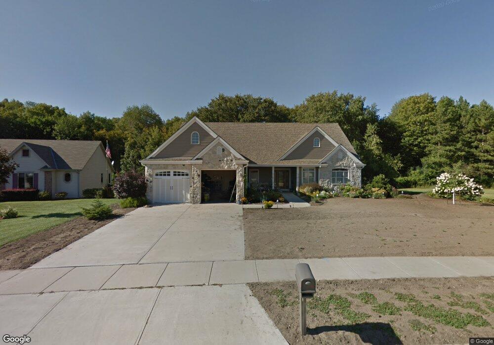
1146 Auburn Rd West Bend, WI 53090
Estimated Value: $506,000 - $657,000
4
Beds
4
Baths
2,846
Sq Ft
$202/Sq Ft
Est. Value
About This Home
This home is located at 1146 Auburn Rd, West Bend, WI 53090 and is currently estimated at $575,181, approximately $202 per square foot. 1146 Auburn Rd is a home located in Washington County with nearby schools including Fair Park Elementary School, Silverbrook Intermediate School, and East High School.
Ownership History
Date
Name
Owned For
Owner Type
Purchase Details
Closed on
Apr 3, 2017
Sold by
Wilberg Marilyn
Bought by
Welzien James D and Welzien Jenna R
Current Estimated Value
Home Financials for this Owner
Home Financials are based on the most recent Mortgage that was taken out on this home.
Original Mortgage
$360,000
Interest Rate
4.1%
Mortgage Type
New Conventional
Create a Home Valuation Report for This Property
The Home Valuation Report is an in-depth analysis detailing your home's value as well as a comparison with similar homes in the area
Home Values in the Area
Average Home Value in this Area
Purchase History
| Date | Buyer | Sale Price | Title Company |
|---|---|---|---|
| Welzien James D | $379,000 | Abstract & Title Company |
Source: Public Records
Mortgage History
| Date | Status | Borrower | Loan Amount |
|---|---|---|---|
| Previous Owner | Welzien James D | $360,000 |
Source: Public Records
Tax History Compared to Growth
Tax History
| Year | Tax Paid | Tax Assessment Tax Assessment Total Assessment is a certain percentage of the fair market value that is determined by local assessors to be the total taxable value of land and additions on the property. | Land | Improvement |
|---|---|---|---|---|
| 2024 | $7,019 | $532,200 | $63,100 | $469,100 |
| 2023 | $6,255 | $361,400 | $75,100 | $286,300 |
| 2022 | $6,444 | $361,400 | $75,100 | $286,300 |
| 2021 | $6,629 | $361,400 | $75,100 | $286,300 |
| 2020 | $6,484 | $361,400 | $75,100 | $286,300 |
| 2019 | $6,286 | $361,400 | $75,100 | $286,300 |
| 2018 | $6,094 | $361,400 | $75,100 | $286,300 |
| 2017 | $6,073 | $323,700 | $75,100 | $248,600 |
| 2016 | $6,118 | $323,700 | $75,100 | $248,600 |
| 2015 | $6,182 | $323,700 | $75,100 | $248,600 |
| 2014 | $6,182 | $323,700 | $75,100 | $248,600 |
| 2013 | $6,680 | $323,700 | $75,100 | $248,600 |
Source: Public Records
Map
Nearby Homes
- 1401 Lee Ave
- 829 Royal Dr
- Lt2 N River Rd
- Lt1 N River Rd
- Lt3 N River Rd
- 1363 Legion Cir
- 1117 Schmidt Rd Unit 2
- LT4 River Rd
- 1123 Marcia Ave Unit 206
- 1311 Daisy Dr
- 2008 Lenora Dr
- 2149 Briar Dr
- 628 Victoria St
- 2112 Deerfield Dr
- 511 Robin St
- 1519 E Washington St
- 801 E Washington St
- 1509 Monroe St
- 1348 Fond du Lac St
- 2050 Stratford Rd