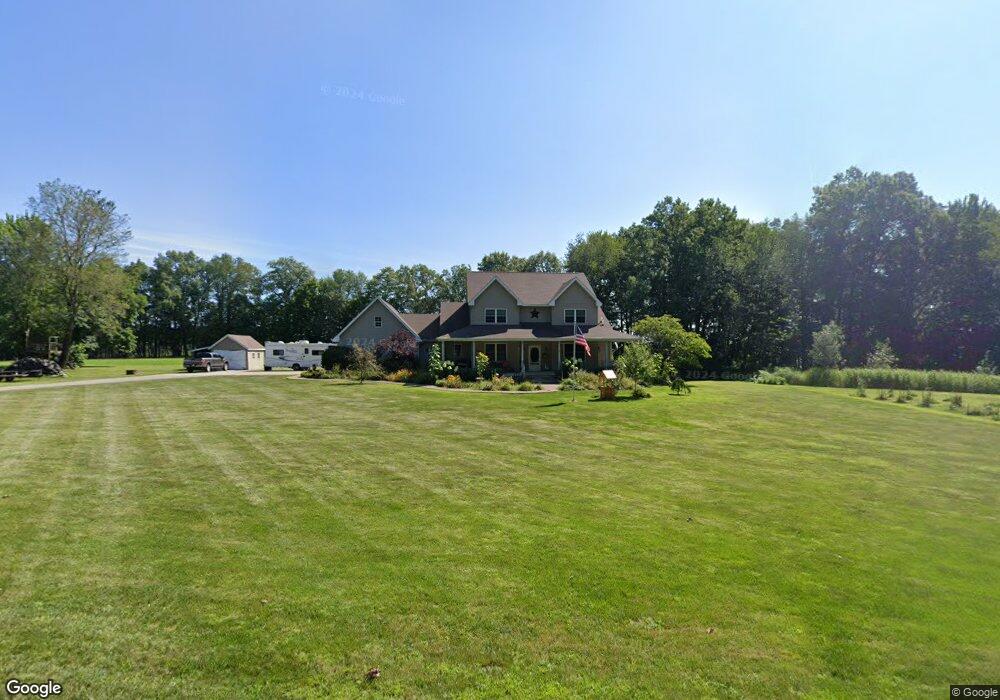
11471 F Dr S Ceresco, MI 49033
Estimated Value: $534,000 - $686,000
5
Beds
5
Baths
3,252
Sq Ft
$185/Sq Ft
Est. Value
About This Home
This home is located at 11471 F Dr S, Ceresco, MI 49033 and is currently estimated at $601,873, approximately $185 per square foot. 11471 F Dr S is a home located in Calhoun County with nearby schools including Harper Creek Middle School and Harper Creek High School.
Ownership History
Date
Name
Owned For
Owner Type
Purchase Details
Closed on
Oct 6, 2020
Sold by
Hadlich Kelly C and Hadlich Susan N
Bought by
Burkart Matthew and Burkart Rebecca
Current Estimated Value
Purchase Details
Closed on
May 20, 2004
Sold by
Rowe Carolee A and Carolee A Rowe Living Trust
Bought by
Hadlich Kelly C and Hadlich Susan N
Purchase Details
Closed on
Jan 8, 2001
Sold by
Rowe Carolee A and Rowe Trust
Bought by
Hadlich Kelly C and Hadlich Susan N
Create a Home Valuation Report for This Property
The Home Valuation Report is an in-depth analysis detailing your home's value as well as a comparison with similar homes in the area
Home Values in the Area
Average Home Value in this Area
Purchase History
| Date | Buyer | Sale Price | Title Company |
|---|---|---|---|
| Burkart Matthew | $400,000 | None Available | |
| Hadlich Kelly C | $45,000 | -- | |
| Hadlich Kelly C | $45,000 | -- |
Source: Public Records
Tax History Compared to Growth
Tax History
| Year | Tax Paid | Tax Assessment Tax Assessment Total Assessment is a certain percentage of the fair market value that is determined by local assessors to be the total taxable value of land and additions on the property. | Land | Improvement |
|---|---|---|---|---|
| 2025 | $13,718 | $301,200 | $0 | $0 |
| 2024 | $10,423 | $276,200 | $0 | $0 |
| 2023 | $11,517 | $254,000 | $0 | $0 |
| 2022 | $11,517 | $234,200 | $0 | $0 |
| 2021 | $11,169 | $219,000 | $0 | $0 |
| 2020 | $6,025 | $198,200 | $0 | $0 |
| 2019 | $0 | $189,300 | $0 | $0 |
| 2018 | $0 | $182,400 | $29,600 | $152,800 |
| 2017 | $0 | $178,100 | $0 | $0 |
| 2016 | $0 | $171,500 | $0 | $0 |
| 2015 | -- | $170,600 | $49,832 | $120,768 |
| 2014 | -- | $174,300 | $49,832 | $124,468 |
Source: Public Records
Map
Nearby Homes
- 11445 F Dr S
- 10047 11 Mile Rd
- 10660 D Dr S
- 11506 11 Mile Rd
- V/L 10 Mile Rd
- 9304 I Dr S
- 6703 Oak Grove Rd
- 8295 D Dr S
- 14880 C Dr S
- 11253 Wildwood Dr
- 5055 12 1 2 Mile Rd
- V/L Cedar Lake
- 275 Battle Creek St
- 0 15 1 2 Mile Rd Unit 25024661
- 12460 Beadle Lake Rd
- 100 Long Lake
- 9180 17 Mile Rd
- 106 Lyon Lake Rd
- 17026 H Dr S
- 13028 Harper Crossing