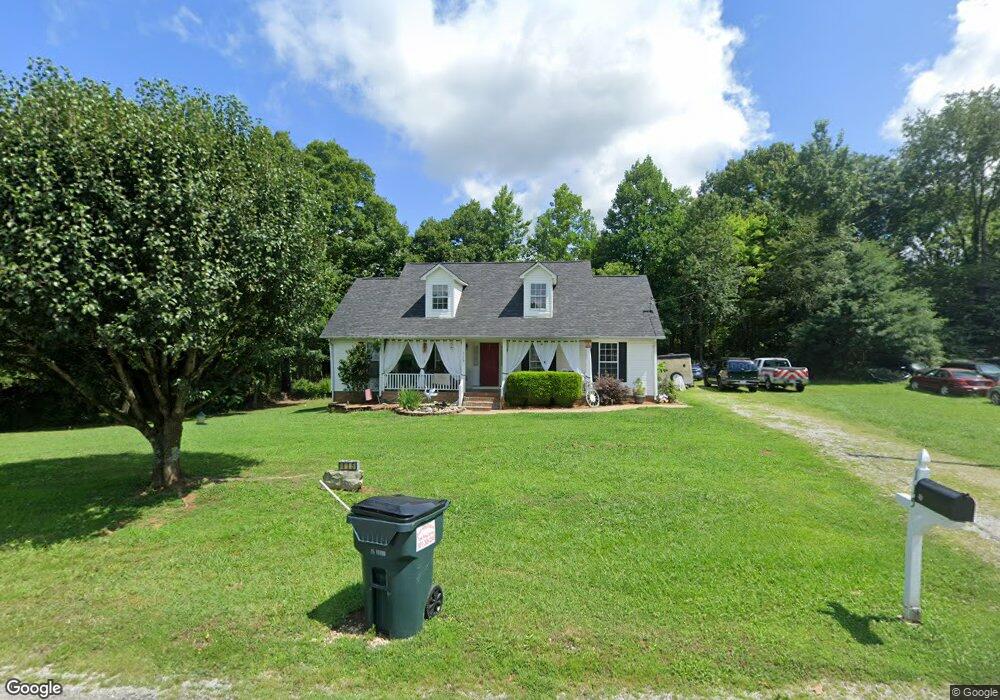
115 Amy Dr Pulaski, TN 38478
Estimated Value: $215,062 - $278,000
Studio
2
Baths
1,484
Sq Ft
$166/Sq Ft
Est. Value
About This Home
This home is located at 115 Amy Dr, Pulaski, TN 38478 and is currently estimated at $246,266, approximately $165 per square foot. 115 Amy Dr is a home located in Giles County with nearby schools including Pulaski Elementary School, Southside Elementary School, and Bridgeforth Middle School.
Ownership History
Date
Name
Owned For
Owner Type
Purchase Details
Closed on
Oct 18, 2016
Sold by
Harney Marcus L
Bought by
Harney Brigette K
Current Estimated Value
Purchase Details
Closed on
May 24, 2000
Sold by
Harney Brigette and Harney Marcus L
Bought by
Gilbert Tammy
Purchase Details
Closed on
Feb 23, 2000
Sold by
Poling P Robert
Bought by
Harney Brigette and Harney Marcus L
Purchase Details
Closed on
Nov 15, 1999
Sold by
Pace Brian and Pace Shasta
Bought by
Gilbert Frederic and Gilbert Jacquel
Home Financials for this Owner
Home Financials are based on the most recent Mortgage that was taken out on this home.
Original Mortgage
$81,458
Interest Rate
7.89%
Purchase Details
Closed on
Nov 4, 1999
Sold by
Pace Brian and Pace Shasta
Bought by
Pace Brian and Pace Shasta
Home Financials for this Owner
Home Financials are based on the most recent Mortgage that was taken out on this home.
Original Mortgage
$81,458
Interest Rate
7.89%
Purchase Details
Closed on
Sep 20, 1999
Sold by
Pride William A and Pride Cynthia
Bought by
Holt Freamon and Holt Ruby M
Home Financials for this Owner
Home Financials are based on the most recent Mortgage that was taken out on this home.
Original Mortgage
$81,458
Interest Rate
7.89%
Purchase Details
Closed on
Jul 23, 1999
Sold by
Harris Tim and Harris Dana
Bought by
Pride William A and Pride Cynthia
Home Financials for this Owner
Home Financials are based on the most recent Mortgage that was taken out on this home.
Original Mortgage
$81,458
Interest Rate
7.89%
Purchase Details
Closed on
Jun 21, 1999
Sold by
Harris Tim and Harris Dana
Bought by
Harris Tim and Harris Dana
Home Financials for this Owner
Home Financials are based on the most recent Mortgage that was taken out on this home.
Original Mortgage
$69,200
Interest Rate
7.27%
Purchase Details
Closed on
Jun 7, 1999
Sold by
Harris Tim and Harris Dana
Bought by
Sanders James E
Home Financials for this Owner
Home Financials are based on the most recent Mortgage that was taken out on this home.
Original Mortgage
$69,200
Interest Rate
7.27%
Purchase Details
Closed on
Aug 19, 1996
Bought by
Poling P Robert P and Poling Debra
Create a Home Valuation Report for This Property
The Home Valuation Report is an in-depth analysis detailing your home's value as well as a comparison with similar homes in the area
Purchase History
| Date | Buyer | Sale Price | Title Company |
|---|---|---|---|
| Harney Brigette K | -- | -- | |
| Gilbert Tammy | $84,300 | -- | |
| Harney Brigette | $85,000 | -- | |
| Gilbert Frederic | $87,600 | -- | |
| Pace Brian | $72,500 | -- | |
| Holt Freamon | $81,500 | -- | |
| Pride William A | $84,500 | -- | |
| Harris Tim | $6,666 | -- | |
| Sanders James E | $6,000 | -- | |
| Poling P Robert P | $112,500 | -- |
Source: Public Records
Mortgage History
| Date | Status | Borrower | Loan Amount |
|---|---|---|---|
| Previous Owner | Poling P Robert P | $81,458 | |
| Previous Owner | Poling P Robert P | $69,200 |
Source: Public Records
Tax History
| Year | Tax Paid | Tax Assessment Tax Assessment Total Assessment is a certain percentage of the fair market value that is determined by local assessors to be the total taxable value of land and additions on the property. | Land | Improvement |
|---|---|---|---|---|
| 2025 | $1,006 | $43,650 | $7,475 | $36,175 |
| 2024 | $867 | $43,650 | $7,475 | $36,175 |
| 2023 | $867 | $43,650 | $7,475 | $36,175 |
| 2022 | $867 | $43,650 | $7,475 | $36,175 |
| 2021 | $722 | $25,550 | $4,100 | $21,450 |
| 2020 | $722 | $25,550 | $4,100 | $21,450 |
| 2019 | $722 | $25,550 | $4,100 | $21,450 |
| 2018 | $722 | $25,550 | $4,100 | $21,450 |
| 2017 | $722 | $25,550 | $4,100 | $21,450 |
| 2016 | $741 | $24,950 | $4,250 | $20,700 |
| 2015 | $691 | $24,950 | $4,250 | $20,700 |
| 2014 | $691 | $24,942 | $0 | $0 |
Source: Public Records
Map
Nearby Homes
- 129 Poling Dr
- 153 Poling Dr
- 159 Poling Dr
- 155 Poling Dr
- 0 Lewisburg Hwy Unit RTC3130421
- 0 Lewisburg Hwy Unit RTC2811267
- 790 Blooming Grove Rd
- 1580 Ragsdale Ln
- 600 Blooming Grove Rd
- 1400 Ragsdale Ln
- 125 Johnson Rd
- 190 Johnson Rd
- 5 Rambling Ridge Rd
- 25 View Point Valley
- 408 McKibbon Ln
- 155 Rambling Ridge
- 365 Glendale Dr
- 19 View Point Valley
- 20 View Point Valley
- 310 Glendale Dr
Your Personal Tour Guide
Ask me questions while you tour the home.