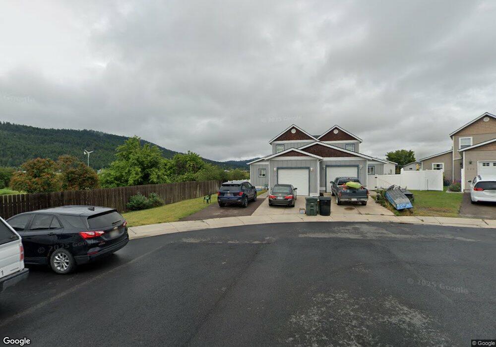
115 Meadow Ct Unit 7 A Kalispell, MT 59901
Estimated Value: $400,802 - $443,000
3
Beds
2
Baths
1,600
Sq Ft
$264/Sq Ft
Est. Value
About This Home
This home is located at 115 Meadow Ct Unit 7 A, Kalispell, MT 59901 and is currently estimated at $421,951, approximately $263 per square foot. 115 Meadow Ct Unit 7 A is a home located in Flathead County with nearby schools including Lillian Peterson School, Kalispell Middle School, and Flathead High School.
Ownership History
Date
Name
Owned For
Owner Type
Purchase Details
Closed on
Mar 19, 2018
Sold by
Olson Justin Michael
Bought by
Nichols James E and Nichols Jennifer M
Current Estimated Value
Home Financials for this Owner
Home Financials are based on the most recent Mortgage that was taken out on this home.
Original Mortgage
$201,010
Outstanding Balance
$171,592
Interest Rate
4.22%
Mortgage Type
New Conventional
Estimated Equity
$250,359
Purchase Details
Closed on
Mar 21, 2014
Sold by
Neuharth Joshua J
Bought by
Olson Justin Michael
Home Financials for this Owner
Home Financials are based on the most recent Mortgage that was taken out on this home.
Original Mortgage
$162,418
Interest Rate
4.25%
Mortgage Type
VA
Create a Home Valuation Report for This Property
The Home Valuation Report is an in-depth analysis detailing your home's value as well as a comparison with similar homes in the area
Home Values in the Area
Average Home Value in this Area
Purchase History
| Date | Buyer | Sale Price | Title Company |
|---|---|---|---|
| Nichols James E | -- | Fidelity National Title | |
| Olson Justin Michael | -- | Insured Titles |
Source: Public Records
Mortgage History
| Date | Status | Borrower | Loan Amount |
|---|---|---|---|
| Open | Nichols James E | $201,010 | |
| Previous Owner | Olson Justin Michael | $162,418 |
Source: Public Records
Tax History Compared to Growth
Tax History
| Year | Tax Paid | Tax Assessment Tax Assessment Total Assessment is a certain percentage of the fair market value that is determined by local assessors to be the total taxable value of land and additions on the property. | Land | Improvement |
|---|---|---|---|---|
| 2025 | $2,078 | $421,100 | $0 | $0 |
| 2024 | $2,670 | $342,900 | $0 | $0 |
| 2023 | $2,887 | $342,900 | $0 | $0 |
| 2022 | $2,495 | $248,400 | $0 | $0 |
| 2021 | $2,673 | $248,400 | $0 | $0 |
| 2020 | $2,454 | $204,000 | $0 | $0 |
| 2019 | $2,460 | $204,000 | $0 | $0 |
| 2018 | $2,197 | $172,200 | $0 | $0 |
| 2017 | $2,204 | $172,200 | $0 | $0 |
| 2016 | $1,914 | $162,000 | $0 | $0 |
| 2015 | $1,915 | $162,000 | $0 | $0 |
| 2014 | $1,988 | $101,389 | $0 | $0 |
Source: Public Records
Map
Nearby Homes
- 819 9th Ave W
- 824 8th St W
- 444 S Meridian Rd
- 514 9th Ave W
- 811 8th Ave W
- 1215 Sunnyside Dr
- 446 8th Ave W
- 901 7th Ave W
- 1308 7th Ave W
- 446 7th Ave W
- 417 8th Ave W
- 1483 & 1485 Western Dr
- 1313 7th Ave W
- 869 Foys Lake Rd
- 8 Primrose Ct
- 112 Boise Ave
- 135 Lupine Dr
- 91 Denver Ave
- 124 Trillium Way
- 162 Lupine Dr