Estimated Value: $92,820 - $134,000
--
Bed
1
Bath
864
Sq Ft
$135/Sq Ft
Est. Value
About This Home
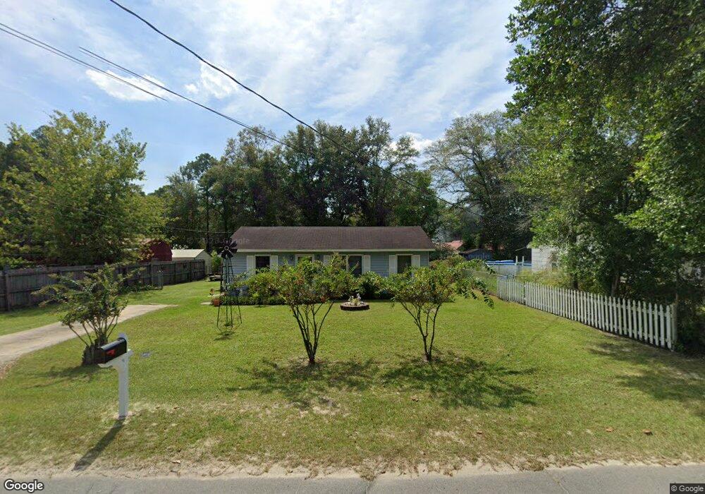
This home is located at 115 N Deborah Cir, Jesup, GA 31546 and is currently estimated at $116,955, approximately $135 per square foot. 115 N Deborah Cir is a home located in Wayne County with nearby schools including Martha Rawls Smith Elementary School, Arthur Williams Middle School, and Wayne County High School.
Ownership History
Date
Name
Owned For
Owner Type
Purchase Details
Closed on
Sep 3, 2010
Sold by
Goff Jim C
Bought by
L & L Rentals
Current Estimated Value
Purchase Details
Closed on
Mar 21, 2007
Sold by
Patrick Linda B
Bought by
Goff Jim C
Home Financials for this Owner
Home Financials are based on the most recent Mortgage that was taken out on this home.
Original Mortgage
$25,000
Interest Rate
6.18%
Mortgage Type
New Conventional
Purchase Details
Closed on
Jan 15, 2007
Sold by
Madray Ronald T
Bought by
Strickland Linda C
Purchase Details
Closed on
Apr 1, 1996
Purchase Details
Closed on
Mar 1, 1989
Purchase Details
Closed on
Nov 1, 1978
Purchase Details
Closed on
Jul 1, 1978
Purchase Details
Closed on
Mar 1, 1974
Create a Home Valuation Report for This Property
The Home Valuation Report is an in-depth analysis detailing your home's value as well as a comparison with similar homes in the area
Home Values in the Area
Average Home Value in this Area
Purchase History
| Date | Buyer | Sale Price | Title Company |
|---|---|---|---|
| L & L Rentals | $40,000 | -- | |
| Goff Jim C | $29,000 | -- | |
| Strickland Linda C | -- | -- | |
| -- | -- | -- | |
| -- | $21,000 | -- | |
| -- | -- | -- | |
| -- | -- | -- | |
| -- | -- | -- |
Source: Public Records
Mortgage History
| Date | Status | Borrower | Loan Amount |
|---|---|---|---|
| Previous Owner | Goff Jim C | $25,000 |
Source: Public Records
Tax History Compared to Growth
Tax History
| Year | Tax Paid | Tax Assessment Tax Assessment Total Assessment is a certain percentage of the fair market value that is determined by local assessors to be the total taxable value of land and additions on the property. | Land | Improvement |
|---|---|---|---|---|
| 2024 | $295 | $21,824 | $1,856 | $19,968 |
| 2023 | $495 | $14,000 | $1,852 | $12,148 |
| 2022 | $134 | $14,000 | $1,852 | $12,148 |
| 2021 | $146 | $14,000 | $1,852 | $12,148 |
| 2020 | $152 | $14,000 | $1,852 | $12,148 |
| 2019 | $161 | $14,000 | $1,852 | $12,148 |
| 2018 | $161 | $14,000 | $1,852 | $12,148 |
| 2017 | $116 | $14,000 | $1,852 | $12,148 |
| 2016 | $107 | $14,000 | $1,852 | $12,148 |
| 2014 | $107 | $14,000 | $1,852 | $12,148 |
| 2013 | -- | $14,000 | $1,852 | $12,148 |
Source: Public Records
Map
Nearby Homes
- 0 S Palm St Unit 10609054
- 0 S Palm St Unit 1656795
- 1300 S Palm St
- 1101 S Palm St
- 158 N Deborah Cir
- 805 Littlefield St
- 50 Ac Hwy 301
- 775 Catherine St
- 985 Seven Oaks Rd
- 210 Purser Dr
- 655 Littlefield St
- 945 S Palm St
- 1816 S Palm St
- 1812 S Palm St
- 0 U S 301
- 156 Hannah Dr
- 353 Chase Dr
- 112 Vixenhill Dr
- 13 N Eagle Dr
- 113 Vixenhill Dr
- LT28 Blk B Harrison Village
- 123 N Deborah Cir
- 118 S Deborah Cir
- 1140 S Palm St
- 114 S Deborah Cir
- 118 N Deborah Cir
- 122 S Deborah Cir
- 127 N Deborah Cir
- 122 N Deborah Cir
- 126 S Deborah Cir
- 1110 S Palm St
- 115 S Deborah Cir
- 131 N Deborah Cir
- 126 N Deborah Cir
- 135 N Deborah Cir
- Hwy 301 S Palm St
- HIGHWAY 301 S Palm St
- 0 S Palm St Unit 19438
- 0 S Palm St Unit 1645940
- 0 S Palm St Unit 113329