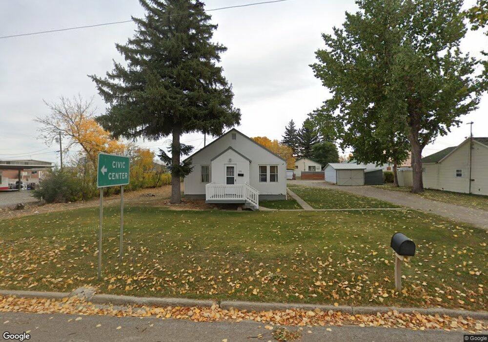
115 N Main St Conrad, MT 59425
Estimated Value: $125,609 - $148,000
2
Beds
1
Bath
960
Sq Ft
$143/Sq Ft
Est. Value
About This Home
This home is located at 115 N Main St, Conrad, MT 59425 and is currently estimated at $137,152, approximately $142 per square foot. 115 N Main St is a home located in Pondera County with nearby schools including Meadowlark School, Utterback Middle School (7-8), and Conrad High School.
Ownership History
Date
Name
Owned For
Owner Type
Purchase Details
Closed on
Dec 29, 2023
Sold by
Bushong Michael
Bought by
Siskin Lane Properties Llc 115 N Main Se
Current Estimated Value
Purchase Details
Closed on
Jun 14, 2022
Sold by
Foster Rebecca L
Bought by
Bushong Michael
Home Financials for this Owner
Home Financials are based on the most recent Mortgage that was taken out on this home.
Original Mortgage
$87,200
Interest Rate
5.52%
Mortgage Type
Construction
Purchase Details
Closed on
Nov 12, 2013
Bought by
Foster Rebecca L
Purchase Details
Closed on
Jun 19, 2007
Bought by
Foster Rebecca L
Create a Home Valuation Report for This Property
The Home Valuation Report is an in-depth analysis detailing your home's value as well as a comparison with similar homes in the area
Home Values in the Area
Average Home Value in this Area
Purchase History
| Date | Buyer | Sale Price | Title Company |
|---|---|---|---|
| Siskin Lane Properties Llc 115 N Main Se | -- | Attorney Only | |
| Bushong Michael | $85,456 | First American Title Co Mt Inc | |
| Foster Rebecca L | -- | -- | |
| Foster Rebecca L | -- | -- |
Source: Public Records
Mortgage History
| Date | Status | Borrower | Loan Amount |
|---|---|---|---|
| Previous Owner | Bushong Michael | $87,200 |
Source: Public Records
Tax History
| Year | Tax Paid | Tax Assessment Tax Assessment Total Assessment is a certain percentage of the fair market value that is determined by local assessors to be the total taxable value of land and additions on the property. | Land | Improvement |
|---|---|---|---|---|
| 2025 | $638 | $128,000 | $0 | $0 |
| 2024 | $1,022 | $106,300 | $0 | $0 |
| 2023 | $1,244 | $106,300 | $0 | $0 |
| 2022 | $702 | $65,900 | $0 | $0 |
| 2021 | $720 | $65,900 | $0 | $0 |
| 2020 | $830 | $58,100 | $0 | $0 |
| 2019 | $818 | $58,100 | $0 | $0 |
| 2018 | $797 | $55,500 | $0 | $0 |
| 2017 | $783 | $55,500 | $0 | $0 |
| 2016 | $774 | $58,400 | $0 | $0 |
| 2015 | $706 | $58,400 | $0 | $0 |
| 2014 | $355 | $17,649 | $0 | $0 |
Source: Public Records
Map
Nearby Homes
- 102 N Virginia St
- 2 N Maryland St
- 104 N Delaware St
- 1 S Delaware St
- 13 S Wisconsin St
- 113 S Delaware St
- 119 S Dakota St
- 302 S Wisconsin St
- 417 4th Ave SW
- 407 S Illinois St
- 408 S Michigan St
- 412 S Iowa St
- 509 S Michigan St
- 601 S Michigan St
- 946 Lederer Rd
- 115 Brady St N
- Lot 7 and 8 3rd Ave SW
- Lot 9 3rd Ave SW
- 2820 5th Ln NW
- 701 Illinois Ave
Your Personal Tour Guide
Ask me questions while you tour the home.