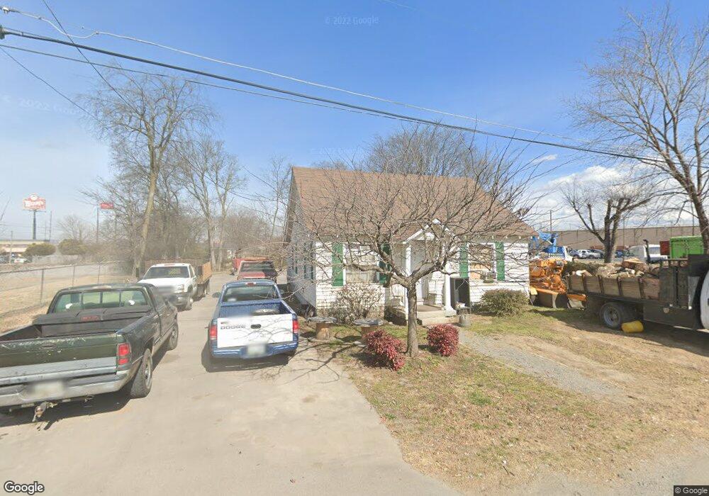
115 Public Dr Murfreesboro, TN 37127
Estimated Value: $186,000 - $285,000
--
Bed
1
Bath
784
Sq Ft
$285/Sq Ft
Est. Value
About This Home
This home is located at 115 Public Dr, Murfreesboro, TN 37127 and is currently estimated at $223,200, approximately $284 per square foot. 115 Public Dr is a home located in Rutherford County with nearby schools including Black Fox Elementary School, Christiana Middle School, and Riverdale High School.
Ownership History
Date
Name
Owned For
Owner Type
Purchase Details
Closed on
Mar 29, 2005
Sold by
Roy Robinson
Bought by
Charlie Cook
Current Estimated Value
Home Financials for this Owner
Home Financials are based on the most recent Mortgage that was taken out on this home.
Original Mortgage
$52,000
Interest Rate
5.74%
Purchase Details
Closed on
Dec 21, 2000
Sold by
James Vaughter
Bought by
Robinson and Elsie
Create a Home Valuation Report for This Property
The Home Valuation Report is an in-depth analysis detailing your home's value as well as a comparison with similar homes in the area
Home Values in the Area
Average Home Value in this Area
Purchase History
| Date | Buyer | Sale Price | Title Company |
|---|---|---|---|
| Charlie Cook | $65,000 | -- | |
| Robinson | $41,500 | -- |
Source: Public Records
Mortgage History
| Date | Status | Borrower | Loan Amount |
|---|---|---|---|
| Closed | Robinson | $52,000 |
Source: Public Records
Tax History Compared to Growth
Tax History
| Year | Tax Paid | Tax Assessment Tax Assessment Total Assessment is a certain percentage of the fair market value that is determined by local assessors to be the total taxable value of land and additions on the property. | Land | Improvement |
|---|---|---|---|---|
| 2025 | $1,178 | $41,650 | $13,750 | $27,900 |
| 2024 | $1,178 | $41,650 | $13,750 | $27,900 |
| 2023 | $781 | $41,650 | $13,750 | $27,900 |
| 2022 | $673 | $41,650 | $13,750 | $27,900 |
| 2021 | $365 | $16,450 | $9,125 | $7,325 |
| 2020 | $365 | $16,450 | $9,125 | $7,325 |
| 2019 | $365 | $16,450 | $9,125 | $7,325 |
| 2018 | $501 | $16,450 | $0 | $0 |
| 2017 | $497 | $12,800 | $0 | $0 |
| 2016 | $497 | $12,800 | $0 | $0 |
| 2015 | $497 | $12,800 | $0 | $0 |
| 2014 | $318 | $12,800 | $0 | $0 |
| 2013 | -- | $11,275 | $0 | $0 |
Source: Public Records
Map
Nearby Homes
- 509 Lilly Ln
- 515 Crocus Ct
- 326 Warrior Dr
- 710 Saratoga Dr
- 542 Warrior Dr
- 1341 Shearron Ct
- 1118 Houston Dr
- 1280 Middle Tennessee Blvd Unit C2
- 1280 Middle Tennessee Blvd Unit D6
- 953 Warrior Dr
- 1419 Ascot Close
- 1103 Virginia Ave
- 923 SE Broad St Unit 4
- 1810 Brighton Dr
- 1003 Tyler Ct
- 2453 New Holland Cir
- 2449 New Holland Cir
- 1315 Bradyville Pike Unit 2
- 1315 Bradyville Pike Unit 1
- 1919 Chartwell Ct
- 119 Public Dr
- 116 Porter St
- 120 Porter St
- 105 Public Dr
- 115 Porter St
- 205 Porter St
- 113 Porter St
- 110 S Rutherford Blvd
- 106 S Rutherford Blvd
- 112 S Rutherford Blvd
- 2021 S Church St
- 135 W Rutherford Blvd
- 135 S Rutherford Blvd
- 0 Southpointe Way Unit 1502464
- 0 Southpointe Way Unit RTC1181195
- 0 Southpointe Way Unit 2004288
- 0 Southpointe Way Unit 2004287
- 2030 S Church St
- 0 Business Campus Dr Unit 1927942
- 0 Business Campus Dr Unit 1894893