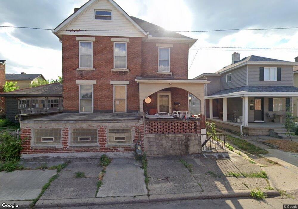
115 S Grubb St Columbus, OH 43215
East Franklinton NeighborhoodEstimated Value: $207,000 - $416,000
4
Beds
1
Bath
1,684
Sq Ft
$188/Sq Ft
Est. Value
About This Home
This home is located at 115 S Grubb St, Columbus, OH 43215 and is currently estimated at $316,291, approximately $187 per square foot. 115 S Grubb St is a home located in Franklin County with nearby schools including Starling PK-8, Sullivant Elementary School, and West High School.
Ownership History
Date
Name
Owned For
Owner Type
Purchase Details
Closed on
Jun 3, 2011
Sold by
Rodriguez David
Bought by
Rodriguez Properties Llc
Current Estimated Value
Purchase Details
Closed on
Jul 22, 2008
Sold by
Deutsche Bank National Trust Co
Bought by
Rodriguez David
Purchase Details
Closed on
Jul 1, 2008
Sold by
Bleas Mary
Bought by
Deutsche Bank National Trust Co and Ffmlt Trust 2006-Ff13 Mortgage Pass Thro
Purchase Details
Closed on
Aug 20, 1991
Bought by
Bleas Mary
Purchase Details
Closed on
Nov 6, 1987
Purchase Details
Closed on
Jan 1, 1986
Create a Home Valuation Report for This Property
The Home Valuation Report is an in-depth analysis detailing your home's value as well as a comparison with similar homes in the area
Home Values in the Area
Average Home Value in this Area
Purchase History
| Date | Buyer | Sale Price | Title Company |
|---|---|---|---|
| Rodriguez Properties Llc | -- | Arrow Title | |
| Rodriguez David | $15,000 | Accutitle Agency Inc | |
| Deutsche Bank National Trust Co | $37,170 | Allodial | |
| Bleas Mary | -- | -- | |
| -- | -- | -- | |
| -- | $11,600 | -- |
Source: Public Records
Tax History
| Year | Tax Paid | Tax Assessment Tax Assessment Total Assessment is a certain percentage of the fair market value that is determined by local assessors to be the total taxable value of land and additions on the property. | Land | Improvement |
|---|---|---|---|---|
| 2025 | $2,878 | $62,790 | $30,520 | $32,270 |
| 2024 | $2,878 | $62,790 | $30,520 | $32,270 |
| 2023 | $2,842 | $62,790 | $30,520 | $32,270 |
| 2022 | $901 | $16,950 | $1,440 | $15,510 |
| 2021 | $902 | $16,950 | $1,440 | $15,510 |
| 2020 | $904 | $16,950 | $1,440 | $15,510 |
| 2019 | $877 | $14,110 | $1,190 | $12,920 |
| 2018 | $910 | $14,110 | $1,190 | $12,920 |
| 2017 | $877 | $14,110 | $1,190 | $12,920 |
| 2016 | $1,037 | $15,270 | $1,510 | $13,760 |
| 2015 | $944 | $15,270 | $1,510 | $13,760 |
| 2014 | $947 | $15,270 | $1,510 | $13,760 |
| 2013 | $519 | $16,975 | $1,680 | $15,295 |
Source: Public Records
Map
Nearby Homes
- 536 W Town St
- 538 W Town St
- 642 Sullivant Ave Unit 642
- 498 W Town St
- 45 N Hartford Ave
- 49 S Hartford Ave
- The Summit Plan at Homes on Hartford - Single Family
- 45 S Hartford Ave
- 753 1/2 Sullivant Ave
- 757 Bellows Ave
- 33 N Hartford Ave
- 72 Avondale Ave
- 813 Campbell Ave
- 186 Avondale Ave Unit 188
- 286 Avondale Ave
- 273 Avondale Ave
- 378 Hawkes Ave
- 61 Dakota Ave
- 69 Rodgers Ave
- 73 Rodgers Ave
- 111 S Grubb St
- 105 S Grubb St
- 646 W Chapel St
- 650 W Chapel St
- 653 W State St
- 642 W Chapel St
- 654 W Chapel St
- 646 W State St
- 648 W State St
- 644 W State St
- 642 W State St
- 654 W State St
- 641 W Chapel St
- 626 W State St
- 628 W State St Unit 630
- 647 W Chapel St
- 649 W Chapel St
- 653 W Chapel St
- 657 W Chapel St
- 622 W State St
Your Personal Tour Guide
Ask me questions while you tour the home.