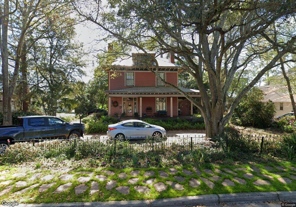
115 W North St Valdosta, GA 31601
Estimated Value: $154,000 - $268,000
--
Bed
2
Baths
2,668
Sq Ft
$74/Sq Ft
Est. Value
About This Home
This home is located at 115 W North St, Valdosta, GA 31601 and is currently estimated at $198,532, approximately $74 per square foot. 115 W North St is a home located in Lowndes County with nearby schools including S.L. Mason Elementary School, Valdosta Middle School, and Valdosta High School.
Ownership History
Date
Name
Owned For
Owner Type
Purchase Details
Closed on
Mar 26, 1999
Sold by
Braziel Marti L
Bought by
Schert Marti L and Schert Dani H
Current Estimated Value
Purchase Details
Closed on
Jun 3, 1988
Bought by
Braziel Marti L
Purchase Details
Closed on
Sep 27, 1982
Bought by
Scott Jeffrey D Etal
Purchase Details
Closed on
Oct 29, 1981
Bought by
Coleman Gloris M Etal
Purchase Details
Closed on
Jun 15, 1979
Bought by
Coleman Gloria M Etal
Purchase Details
Closed on
Nov 30, 1973
Bought by
Coleman Wilby C Etal
Create a Home Valuation Report for This Property
The Home Valuation Report is an in-depth analysis detailing your home's value as well as a comparison with similar homes in the area
Home Values in the Area
Average Home Value in this Area
Purchase History
| Date | Buyer | Sale Price | Title Company |
|---|---|---|---|
| Schert Marti L | -- | -- | |
| Braziel Marti L | $64,000 | -- | |
| Scott Jeffrey D Etal | $25,000 | -- | |
| Coleman Gloris M Etal | $1,300 | -- | |
| Coleman Gloria M Etal | $8,300 | -- | |
| Coleman Wilby C Etal | -- | -- |
Source: Public Records
Tax History Compared to Growth
Tax History
| Year | Tax Paid | Tax Assessment Tax Assessment Total Assessment is a certain percentage of the fair market value that is determined by local assessors to be the total taxable value of land and additions on the property. | Land | Improvement |
|---|---|---|---|---|
| 2024 | $1,482 | $59,054 | $5,504 | $53,550 |
| 2023 | $1,482 | $59,054 | $5,504 | $53,550 |
| 2022 | $1,214 | $41,924 | $5,504 | $36,420 |
| 2021 | $1,249 | $41,924 | $5,504 | $36,420 |
| 2020 | $1,276 | $41,924 | $5,504 | $36,420 |
| 2019 | $1,275 | $41,924 | $5,504 | $36,420 |
| 2018 | $1,292 | $41,924 | $5,504 | $36,420 |
| 2017 | $1,301 | $41,924 | $5,504 | $36,420 |
| 2016 | $1,039 | $34,744 | $5,504 | $29,240 |
| 2015 | -- | $34,744 | $5,504 | $29,240 |
| 2014 | $970 | $34,744 | $5,504 | $29,240 |
Source: Public Records
Map
Nearby Homes
- 803 Johnson St
- 516 N Oak St
- 701 Johnson St
- 410 W Adair St
- 0 Canal St
- 311 E Adair St
- * Sustella - Green Unit 3
- 704 3rd Ave
- 1110 N Patterson St
- 311 Webster St
- 400 E Gordon St
- 136 N Patterson St
- 808 W Adair St
- 503 N Troup St
- 404 Floyd St
- 105 N Ashley St
- 201 N Wells St
- 724 J L Lomax Dr
- 7 W Hill Ave
- 609 Jones St
- 103 W North St
- 610 N Patterson St
- 108 W North St
- 609 N Toombs St
- 110 W North St
- 106 W North St
- 607 N Toombs St
- 703 N Toombs St
- 605 N Toombs St
- 602 N Patterson St
- 600 N Patterson St
- 700 N Toombs St
- 105 W Adair St
- 111 W Adair St
- 611 N Patterson St
- 609 N Patterson St
- 508 N Patterson St
- 706 N Toombs St
- 607 N Patterson St
- 20 Ac+/- Moore Crossing Rd