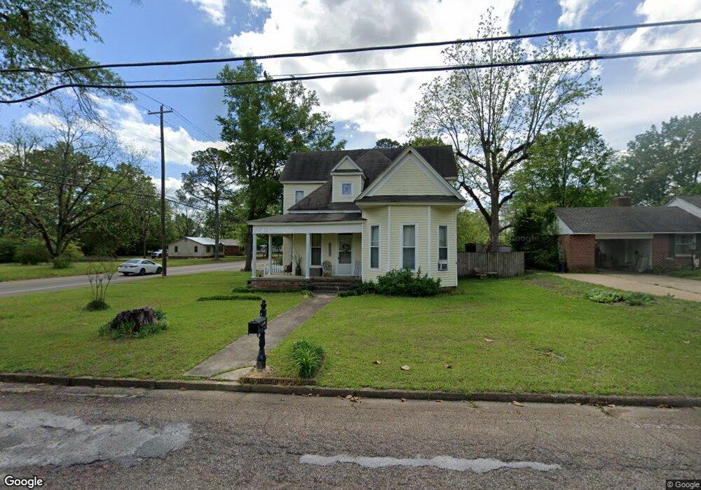
1150 E Broad St West Point, MS 39773
Estimated Value: $154,744 - $215,000
3
Beds
--
Bath
2,160
Sq Ft
$82/Sq Ft
Est. Value
About This Home
This home is located at 1150 E Broad St, West Point, MS 39773 and is currently estimated at $177,686, approximately $82 per square foot. 1150 E Broad St is a home located in Clay County with nearby schools including East Side Elementary School, West Clay Elementary School, and Church Hill Elementary School.
Ownership History
Date
Name
Owned For
Owner Type
Purchase Details
Closed on
May 31, 2018
Sold by
Francis Mary Edwards
Bought by
Edwards James Robert
Current Estimated Value
Home Financials for this Owner
Home Financials are based on the most recent Mortgage that was taken out on this home.
Original Mortgage
$32,842
Outstanding Balance
$9,336
Interest Rate
4.5%
Mortgage Type
Purchase Money Mortgage
Estimated Equity
$168,350
Create a Home Valuation Report for This Property
The Home Valuation Report is an in-depth analysis detailing your home's value as well as a comparison with similar homes in the area
Purchase History
| Date | Buyer | Sale Price | Title Company |
|---|---|---|---|
| Edwards James Robert | -- | -- |
Source: Public Records
Mortgage History
| Date | Status | Borrower | Loan Amount |
|---|---|---|---|
| Open | Edwards James Robert | $32,842 |
Source: Public Records
Tax History
| Year | Tax Paid | Tax Assessment Tax Assessment Total Assessment is a certain percentage of the fair market value that is determined by local assessors to be the total taxable value of land and additions on the property. | Land | Improvement |
|---|---|---|---|---|
| 2025 | $450 | $11,062 | $1,976 | $9,086 |
| 2024 | $450 | $11,062 | $1,976 | $9,086 |
| 2023 | $1,119 | $9,482 | $1,976 | $7,506 |
| 2022 | $367 | $9,482 | $1,976 | $7,506 |
| 2021 | $366 | $9,482 | $1,976 | $7,506 |
| 2020 | $365 | $9,482 | $1,976 | $7,506 |
| 2019 | $337 | $9,414 | $1,976 | $7,438 |
| 2018 | $316 | $9,414 | $1,976 | $7,438 |
| 2017 | $316 | $9,414 | $1,976 | $7,438 |
| 2016 | $298 | $9,414 | $1,976 | $7,438 |
| 2015 | $276 | $8,633 | $1,976 | $6,657 |
| 2014 | $221 | $8,633 | $1,976 | $6,657 |
| 2013 | $221 | $8,633 | $1,976 | $6,657 |
Source: Public Records
Map
Nearby Homes
- 913 E Westbrook St
- 341 Mccord St
- 105 Converse Dr
- 228 Mccord St
- 27045 E Main St
- 26596 E Main St
- 551 E Westbrook St
- 507 S Eshman Ave
- 278 Converse Dr
- 472 S Eshman Ave
- 329 Converse Dr
- 44 Torbert Dr
- 405 S Eshman Ave
- 26852 E Main St
- 1046 E Brame Ave
- 761 E Morrow St
- 26788 E Main St
- 238 Calhoun St
- 530 E Morrow St
- 15 David St
- 1138 E Broad St
- 1167 E Broad St
- 228 S Eshman Ave
- 1135 E Broad St
- 1128 E Broad St
- 1141 E Westbrook St
- 326 S Eshman Ave
- 224 S Eshman Ave
- 891 S Eshman Ave
- 221 N Eshman Ave
- 790 S Eshman Ave
- 330 S Eshman Ave
- 222 S Eshman Ave
- 1116 E Broad St
- 1154 Durrett Cove
- 334 S Eshman Ave
- 1115 E Broad St
- 402 S Eshman Ave
- 1138 E Westbrook St
- 1152 E Westbrook St
Your Personal Tour Guide
Ask me questions while you tour the home.