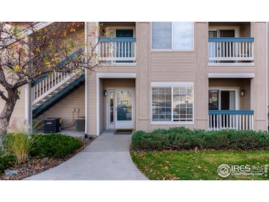
1150 Opal St Unit 101 Broomfield, CO 80020
Miramonte NeighborhoodEstimated payment $2,196/month
Highlights
- Very Popular Property
- Open Floorplan
- Community Pool
- Kohl Elementary School Rated A-
- Clubhouse
- 1 Car Detached Garage
About This Home
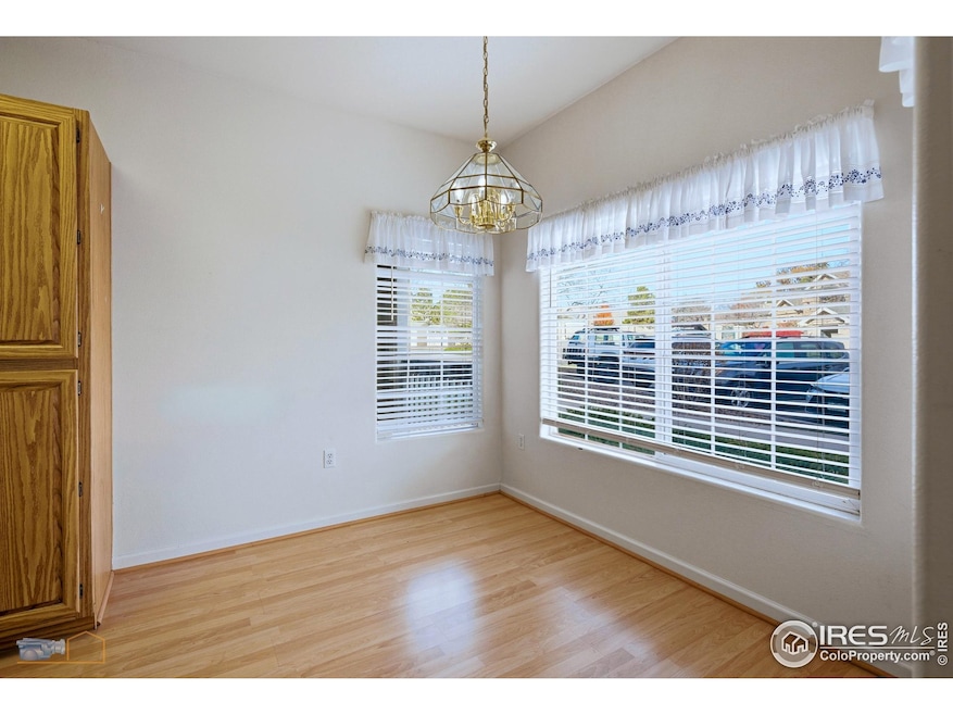
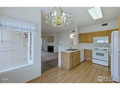
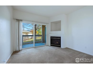
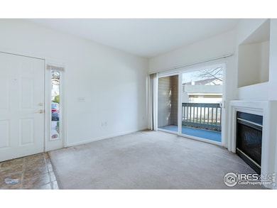
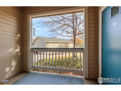
Terrific location with handicap parking in front of this perfect main floor condo. Ensuite primary with access to private covered patio. Living room opens unto a second private covered, fenced patio. Lovely opportunity to relax in personal, private spaces. One car garage with abundant storage shelving. Conveniently King Soopers in just around the corner. Large comfortable living room features gas fireplace and indirect lighting all day. New high output 50 gal water heater with 7 yr warranty. (10/8)New RE_Circ pump with dedicated line. HVAC totally maintained (10/9)New expansion tank(10/8)Ample storage with walk in closet. First class housing at a NO-Frills price. Always a rental. Being sold in As-Is condition. Easy to close quickly.
Townhouse Details
Home Type
- Townhome
Est. Annual Taxes
- $1,968
Year Built
- Built in 1997
Lot Details
- 482 Sq Ft Lot
- No Units Located Below
- North Facing Home
HOA Fees
- $345 Monthly HOA Fees
Parking
- 1 Car Detached Garage
- Garage Door Opener
Home Design
- Entry on the 1st floor
- Wood Frame Construction
- Composition Roof
Interior Spaces
- 1,025 Sq Ft Home
- 1-Story Property
- Open Floorplan
- Ceiling Fan
- Self Contained Fireplace Unit Or Insert
- Gas Fireplace
- Window Treatments
- Living Room with Fireplace
- Attic Fan
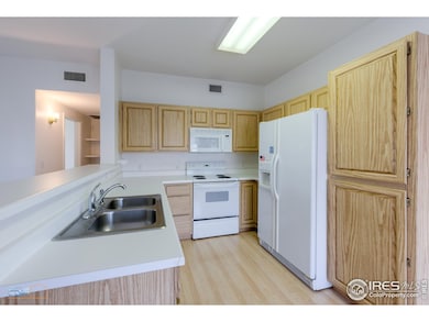
Kitchen
- Eat-In Kitchen
- Electric Oven or Range
- Microwave
- Dishwasher
- Disposal
Flooring
- Carpet
- Vinyl
Bedrooms and Bathrooms
- 2 Bedrooms
- Walk-In Closet
- 2 Full Bathrooms
- Primary bathroom on main floor
Laundry
- Laundry on main level
- Dryer
- Washer
Home Security
Accessible Home Design
- No Interior Steps
- Level Entry For Accessibility
Schools
- Kohl Elementary School
- Broomfield Heights Middle School
- Broomfield High School
Additional Features
- Patio
- Forced Air Heating and Cooling System
Listing and Financial Details
- Assessor Parcel Number R1129306
Community Details
Overview
- Association fees include common amenities, trash, snow removal, ground maintenance, management, maintenance structure, water/sewer, hazard insurance
- Mieramonte Ranch Association, Phone Number (303) 420-4433
- Miramonte Ranch Condos Subdivision
Amenities
- Clubhouse
- Recreation Room
Recreation
- Community Pool
Pet Policy
- Dogs and Cats Allowed
Security
- Storm Doors
- Fire and Smoke Detector
Map
Home Values in the Area
Average Home Value in this Area
Tax History
| Year | Tax Paid | Tax Assessment Tax Assessment Total Assessment is a certain percentage of the fair market value that is determined by local assessors to be the total taxable value of land and additions on the property. | Land | Improvement |
|---|---|---|---|---|
| 2025 | $2,028 | $25,080 | -- | $25,080 |
| 2024 | $2,028 | $21,640 | -- | $21,640 |
| 2023 | $2,024 | $26,270 | -- | $26,270 |
| 2022 | $1,978 | $20,460 | $0 | $20,460 |
| 2021 | $1,968 | $21,050 | $0 | $21,050 |
| 2020 | $1,981 | $21,060 | $0 | $21,060 |
| 2019 | $1,978 | $21,200 | $0 | $21,200 |
| 2018 | $1,594 | $16,890 | $0 | $16,890 |
| 2017 | $1,570 | $18,670 | $0 | $18,670 |
| 2016 | $1,256 | $13,320 | $0 | $13,320 |
| 2015 | $1,213 | $10,890 | $0 | $10,890 |
| 2014 | $1,014 | $10,890 | $0 | $10,890 |
Property History
| Date | Event | Price | List to Sale | Price per Sq Ft |
|---|---|---|---|---|
| 11/06/2025 11/06/25 | For Sale | $320,000 | -- | $312 / Sq Ft |
Purchase History
| Date | Type | Sale Price | Title Company |
|---|---|---|---|
| Warranty Deed | $161,500 | Security Title | |
| Warranty Deed | $167,000 | -- | |
| Deed | $108,000 | -- |
Mortgage History
| Date | Status | Loan Amount | Loan Type |
|---|---|---|---|
| Open | $110,000 | Fannie Mae Freddie Mac | |
| Previous Owner | $161,900 | FHA |
Source: IRES MLS
MLS Number: 1047135
APN: 1575-26-3-36-017
Disclaimer: Certain information contained herein is derived from information provided by parties other than Homes.com. All information provided is deemed reliable, but is not guaranteed to be accurate and should be independently verified.
![]() Information source: Information and Real Estate Services, LLC. Provided for limited non-commercial use only under IRES Rules © Copyright IRES.
Information source: Information and Real Estate Services, LLC. Provided for limited non-commercial use only under IRES Rules © Copyright IRES.
Listing information is provided exclusively for consumers' personal, non-commercial use and may not be used for any purpose other than to identify prospective properties consumers may be interested in purchasing.
Information deemed reliable but not guaranteed by the MLS.
- 1148 Opal St Unit 101
- 1176 Opal St Unit 102
- 1190 Opal St Unit 104
- 1190 W 11th Ct
- 1320 W 12th Ave
- 1010 Opal St Unit 102
- 1035 Iris St
- 2191 Ridge Dr
- 1320 Holly Dr E
- 2150 Ridge Dr
- 1196 Sunset Dr
- 1170 Alter Way
- 639 Quartz Way
- 680 Kalmia Way
- 640 Kalmia Way
- 1606 Iris St
- 685 Daphne St
- 1677 Hemlock Way
- 1087 Lilac St
- 1660 Emerald St
- 2200 W 10th Ave
- 70 Garden Center
- 1145 W 6th Ave
- 2882 Ridge Dr Unit A
- 170-290 Marble St
- 185 Emerald St
- 165 Iris St
- 111 Flint Way
- 630 W 1st Ave
- 7105 W 120th Ave
- 7005-7035 W 120th Ave
- 9001 Interlocken Loop
- 11775 Wadsworth Blvd
- 1030 E 10th Ave
- 22 Amesbury St
- 1123 E 12th Ave
- 8251 Transit Way
- 11697 Destination Dr
- 138 Willow Place S
- 999 E 1st Ave
