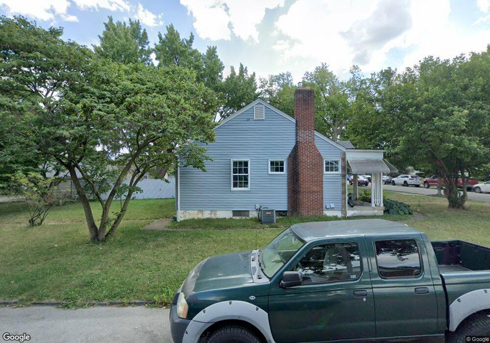
1155 W 6th Ave Unit TWENTY Columbus, OH 43212
Fifth by Northwest NeighborhoodEstimated Value: $39,000 - $160,000
3
Beds
1
Bath
979
Sq Ft
$127/Sq Ft
Est. Value
About This Home
This home is located at 1155 W 6th Ave Unit TWENTY, Columbus, OH 43212 and is currently estimated at $124,308, approximately $126 per square foot. 1155 W 6th Ave Unit TWENTY is a home located in Franklin County with nearby schools including Cranbrook Elementary School, Ridgeview Middle School, and Centennial High School.
Ownership History
Date
Name
Owned For
Owner Type
Purchase Details
Closed on
Jul 16, 2025
Sold by
Beery Faith and Beery Mark E
Bought by
Beery Faith and Beery Mark E
Current Estimated Value
Home Financials for this Owner
Home Financials are based on the most recent Mortgage that was taken out on this home.
Original Mortgage
$137,006
Outstanding Balance
$136,772
Interest Rate
6.81%
Mortgage Type
FHA
Estimated Equity
-$12,464
Purchase Details
Closed on
Oct 4, 2011
Sold by
Ross Ervin June and Ross Ervin
Bought by
Simpson Doretha L
Purchase Details
Closed on
May 13, 2010
Sold by
Simpson Ramona
Bought by
Ross Eric and Ross Ervin
Purchase Details
Closed on
Jan 25, 2007
Sold by
Simpson Ramona and Woods Ramona
Bought by
Simpson Ramona and Ramona Simpson Trust
Purchase Details
Closed on
Aug 23, 2006
Sold by
Estate Of Regina Green
Bought by
Green Alonzo and Green Rosevelt
Purchase Details
Closed on
Feb 1, 1987
Create a Home Valuation Report for This Property
The Home Valuation Report is an in-depth analysis detailing your home's value as well as a comparison with similar homes in the area
Home Values in the Area
Average Home Value in this Area
Purchase History
| Date | Buyer | Sale Price | Title Company |
|---|---|---|---|
| Beery Faith | $53,300 | Omni Title | |
| Beery Faith | $119,800 | Omni Title | |
| Beery Faith | $40,000 | Omni Title | |
| Simpson Doretha L | $7,900 | None Available | |
| Simpson Doretha L | $7,900 | None Available | |
| Ross Eric | -- | Attorney | |
| Simpson Ramon | -- | Attorney | |
| Simpson Ramona | -- | Attorney | |
| Green Alonzo | -- | None Available | |
| -- | -- | -- |
Source: Public Records
Mortgage History
| Date | Status | Borrower | Loan Amount |
|---|---|---|---|
| Open | Beery Faith | $137,006 |
Source: Public Records
Tax History Compared to Growth
Tax History
| Year | Tax Paid | Tax Assessment Tax Assessment Total Assessment is a certain percentage of the fair market value that is determined by local assessors to be the total taxable value of land and additions on the property. | Land | Improvement |
|---|---|---|---|---|
| 2024 | $3,554 | $40,670 | $5,460 | $35,210 |
| 2023 | $2,218 | $40,670 | $5,460 | $35,210 |
| 2022 | $1,108 | $17,860 | $3,470 | $14,390 |
| 2021 | $1,026 | $17,860 | $3,470 | $14,390 |
| 2020 | $990 | $17,860 | $3,470 | $14,390 |
| 2019 | $923 | $14,840 | $2,870 | $11,970 |
| 2018 | $602 | $14,840 | $2,870 | $11,970 |
| 2017 | $923 | $14,840 | $2,870 | $11,970 |
| 2016 | $961 | $14,140 | $3,500 | $10,640 |
| 2015 | $875 | $14,140 | $3,500 | $10,640 |
| 2014 | $877 | $14,140 | $3,500 | $10,640 |
| 2013 | $481 | $15,715 | $3,885 | $11,830 |
Source: Public Records
Map
Nearby Homes
- 1126 King Ave Unit 128
- 00 W 7th Ave
- 1364 W 7th Ave
- 1297 Doten Ave
- 1095 W 3rd Ave
- 1093 W 3rd Ave
- 1242 Oxley Rd
- 1240 Oxley Rd
- 1083 W 3rd Ave
- 1225 Eastview Ave
- 1475 W 3rd Ave Unit 204
- 1111 Northwest Blvd Unit 113
- 1398 Lower Green Cir Unit 1398
- 1846 Rhoda Ave
- 1081 W 3rd Ave
- 1081 Northwest Blvd Unit 2
- 1661 Ashland Ave Unit 663
- 1129 Mulford Rd
- 1733 Elmwood Ave
- 1459 Elmwood Ave Unit 1459
- 1161 W 6th Ave Unit TWENTY
- 1147 W 6th Ave Unit TWENTY
- 1141 W 6th Ave Unit TWENTY
- 1169 W 6th Ave Unit TWENTY
- 1524 Doten Ave
- 1175 W 6th Ave Unit TWENTY
- 1133 W 6th Ave Unit TWENTY
- 1518 Doten Ave
- 1127 W 6th Ave Unit TWENTY
- 1183 W 6th Ave Unit TWENTY
- 1514 Doten Ave
- 1121 W 6th Ave Unit TWENTY
- 1162 W 6th Ave Unit TWENTY
- 1144 W 6th Ave Unit TWENTY
- 1168 W 6th Ave Unit 170
- 1515 Virginia Ave
- 1136 W 6th Ave Unit TWENTY
- 1509 Virginia Ave
- 1130 W 6th Ave Unit TWENTY
- 1508 Doten Ave