


1157 Newton St Tallmadge, OH 44278
Estimated payment $1,837/month
Highlights
- 1.69 Acre Lot
- High Ceiling
- No HOA
- Deck
- Stone Countertops
- 2 Car Detached Garage
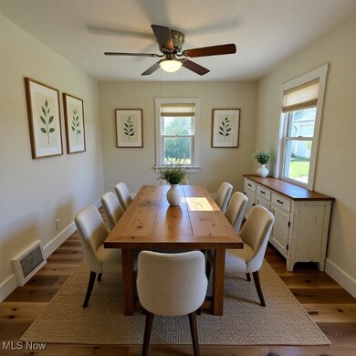
About This Home
Rustic Living with Modern Convenience...This is a rare opportunity to buy a live-in ready home with lots of land conveniently located near expressway access. This home was completely renovated to include the addition of over 750 sq. ft. (bedroom, bath, and finished basement). This 4 bedroom, 2.5 bath home boasts over 2,000 square feet of living space. It features all new plumbing, electrical and mechanicals, a massive lower level en suite bedroom with a walk-in closet, a four-season room, a recreation room, oversized laundry room, an oversized 2 car garage with a huge, oversized driveway situated on 1.686 acres in historic Tallmadge. The kitchen and baths feature large cabinetry with tiled features and nickel hardware. Lots of natural and LED light throughout. The lower level space walks out to grade level and has 2 means of egress. This home is moderately priced at $142/sq ft for quick sale. Tallmadge City Schools. Convenient to 532 and I76. Seller is a licensed real estate agent.
Listing Agent
Ohio Broker Direct Brokerage Email: 614-989-7215, joan@ohiobrokerdirect.com License #386319 Listed on: 10/19/2025
Co-Listing Agent
Ohio Broker Direct Brokerage Email: 614-989-7215, joan@ohiobrokerdirect.com License #2014005193
Home Details
Home Type
- Single Family
Est. Annual Taxes
- $3,776
Year Built
- Built in 1945 | Remodeled
Lot Details
- 1.69 Acre Lot
- South Facing Home
- Back and Front Yard
Parking
- 2 Car Detached Garage
- Oversized Parking
- Gravel Driveway
- Additional Parking
Home Design
- Bungalow
- Fiberglass Roof
- Asphalt Roof
- Wood Siding
- Vinyl Siding
Interior Spaces
- 1.5-Story Property
- High Ceiling
- Ceiling Fan
- Double Pane Windows
- Window Screens
- Storage
- Finished Basement
- Sump Pump
- Fire and Smoke Detector
- Stone Countertops
Bedrooms and Bathrooms
- 4 Bedrooms | 1 Main Level Bedroom
- Walk-In Closet
- 2.5 Bathrooms
Laundry
- Dryer
- Washer
Outdoor Features
- Deck
- Enclosed Patio or Porch
Utilities
- Humidifier
- Forced Air Heating and Cooling System
- Heating System Uses Gas
- Water Softener
Community Details
- No Home Owners Association
- Original Township Subdivision
Listing and Financial Details
- Assessor Parcel Number 6003019
Map
Home Values in the Area
Average Home Value in this Area
Tax History
| Year | Tax Paid | Tax Assessment Tax Assessment Total Assessment is a certain percentage of the fair market value that is determined by local assessors to be the total taxable value of land and additions on the property. | Land | Improvement |
|---|---|---|---|---|
| 2025 | $4,085 | $67,417 | $19,194 | $48,223 |
| 2024 | $2,983 | $67,417 | $19,194 | $48,223 |
| 2023 | $4,085 | $67,417 | $19,194 | $48,223 |
| 2022 | $2,480 | $48,119 | $13,423 | $34,696 |
| 2021 | $2,490 | $48,119 | $13,423 | $34,696 |
| 2020 | $2,471 | $48,120 | $13,420 | $34,700 |
| 2019 | $2,305 | $41,490 | $13,420 | $28,070 |
| 2018 | $2,040 | $41,490 | $13,420 | $28,070 |
| 2017 | $1,841 | $41,490 | $13,420 | $28,070 |
| 2016 | $1,979 | $37,890 | $13,420 | $24,470 |
| 2015 | $1,841 | $37,890 | $13,420 | $24,470 |
| 2014 | $1,829 | $37,890 | $13,420 | $24,470 |
| 2013 | $2,019 | $41,630 | $13,420 | $28,210 |
Property History
| Date | Event | Price | List to Sale | Price per Sq Ft |
|---|---|---|---|---|
| 12/10/2025 12/10/25 | Price Changed | $289,500 | -2.5% | $139 / Sq Ft |
| 10/19/2025 10/19/25 | For Sale | $297,000 | -- | $143 / Sq Ft |
Purchase History
| Date | Type | Sale Price | Title Company |
|---|---|---|---|
| Warranty Deed | $124,000 | None Listed On Document | |
| Interfamily Deed Transfer | -- | -- |
Mortgage History
| Date | Status | Loan Amount | Loan Type |
|---|---|---|---|
| Closed | $185,000 | Construction |
Source: MLS Now
MLS Number: 5165892
APN: 60-03019
Disclaimer: Certain information contained herein is derived from information provided by parties other than Homes.com. All information provided is deemed reliable, but is not guaranteed to be accurate and should be independently verified.
![]() IDX information is provided exclusively for personal, non-commercial use, and may not be used for any purpose other than to identify prospective properties consumers may be interested in purchasing. Information is deemed reliable but not guaranteed.
IDX information is provided exclusively for personal, non-commercial use, and may not be used for any purpose other than to identify prospective properties consumers may be interested in purchasing. Information is deemed reliable but not guaranteed.
- V/L Southeast Ave
- 1034 Southeast Ave
- 0 Newton Unit 5174619
- 490 Vandalia Dr
- 1289 Peartree Ct
- 821 Olde Orchard Dr
- 2751 Highline Dr
- 475 Munroe Falls Rd
- 252 Saxe Rd
- 427 Perry Rd
- 2671 Spring Valley Blvd
- 994 Sunset View Blvd
- 128 Byatt Rd
- 0 Gilchrist Rd
- 2700 Martin Rd
- 206 Fawnwood Dr
- 243 S Munroe Rd
- 2369 1/2 Cooledge Ave
- 38 Walnut Ct
- 1168 East Ave
- 3814 Cascades Blvd
- 558 Colony Park Dr Unit 101
- 558 Colony Park Dr Unit 301
- 4047 Mogadore Rd
- 2880 Mogadore Rd
- 2251 Eastwood Ave
- 153 Thorlone Ave
- 2197 Eastwood Ave
- 22 Ansel Ave
- 890 Tallmadge Rd
- 359 Booth Ave
- 2595 Terrace Ave Unit 9
- 2595 Terrace Ave Unit 3
- 306 Northeast Ave
- 120-150 North Ave
- 100 North Ave
- 720 Shadybrook Dr
- 1304 Brookdale Ln
- 1100 Huckleberry Ln
- 1202 Jasmine Dr
