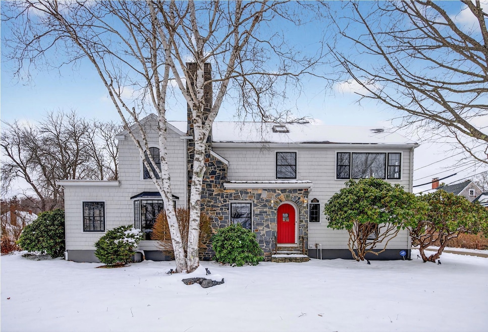
1157 Shore Rd Cape Elizabeth, ME 04107
Estimated payment $7,062/month
Highlights
- Hot Property
- Water Views
- Deck
- Pond Cove Elementary School Rated A
- Colonial Architecture
- Wood Flooring
About This Home
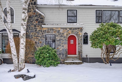
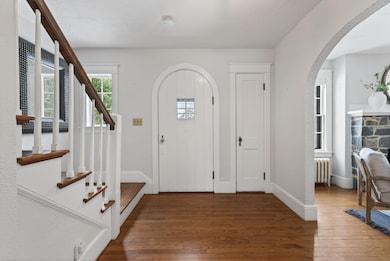
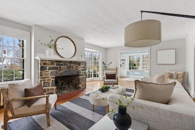
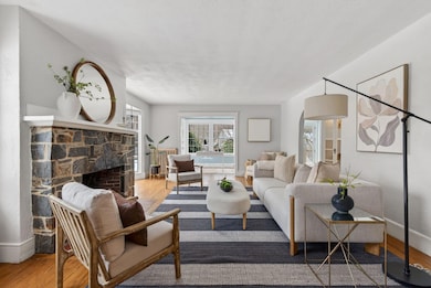
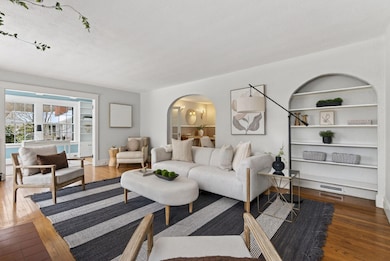
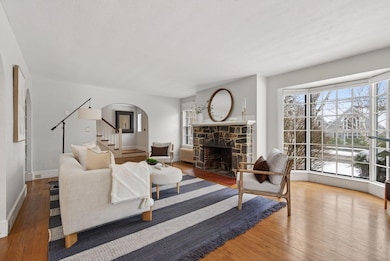
Set on a Shore Road, this colonial offers an inviting blend of charm and everyday function in one of Cape Elizabeth's most loved locations. Hardwood floors, classic built-ins, and graceful arched openings bring warmth and character throughout the home. The kitchen opens directly to the dining area for easy gathering and flow, while a spacious living room and sunroom provide multiple spots to unwind. With five bedrooms and two full baths, there's room for everyone—whether you're hosting for a season or settling in for years to come. Outside there is a beautifully landscaped yard and a generous deck ideal for outdoor dining and entertaining. Enjoy water views and access to Robinson Woods trails right at the end of the street and Pond Cove Beach less than a half mile away. A rare opportunity to enjoy coastal living with neighborhood convenience in the heart of Cape Elizabeth.
Home Details
Home Type
- Single Family
Est. Annual Taxes
- $9,545
Year Built
- Built in 1931
Lot Details
- 0.27 Acre Lot
- Property is zoned RA + Shoreland
Parking
- 1 Car Attached Garage
Property Views
- Water
- Scenic Vista
Home Design
- Colonial Architecture
- Shingle Roof
Interior Spaces
- 2,499 Sq Ft Home
- 1 Fireplace
- Interior Basement Entry
Flooring
- Wood
- Tile
Bedrooms and Bathrooms
- 5 Bedrooms
- Primary bedroom located on second floor
- 2 Full Bathrooms
Outdoor Features
- Deck
Utilities
- No Cooling
- Hot Water Heating System
- Septic Design Available
- Private Sewer
Community Details
- No Home Owners Association
Listing and Financial Details
- Tax Lot 10
- Assessor Parcel Number CAPE-010010U
Map
Home Values in the Area
Average Home Value in this Area
Tax History
| Year | Tax Paid | Tax Assessment Tax Assessment Total Assessment is a certain percentage of the fair market value that is determined by local assessors to be the total taxable value of land and additions on the property. | Land | Improvement |
|---|---|---|---|---|
| 2024 | $8,951 | $813,700 | $411,900 | $401,800 |
| 2023 | $18,178 | $813,700 | $411,900 | $401,800 |
| 2022 | $9,154 | $432,800 | $155,900 | $276,900 |
| 2021 | $8,769 | $432,800 | $155,900 | $276,900 |
| 2020 | $8,621 | $432,800 | $155,900 | $276,900 |
| 2019 | $8,518 | $432,800 | $155,900 | $276,900 |
| 2018 | $8,232 | $432,800 | $155,900 | $276,900 |
| 2017 | $7,790 | $432,800 | $155,900 | $276,900 |
| 2016 | $7,591 | $432,800 | $155,900 | $276,900 |
| 2015 | $7,306 | $432,800 | $155,900 | $276,900 |
| 2013 | $7,046 | $432,800 | $155,900 | $276,900 |
Property History
| Date | Event | Price | List to Sale | Price per Sq Ft |
|---|---|---|---|---|
| 12/05/2025 12/05/25 | For Sale | $1,195,000 | -- | $478 / Sq Ft |
Purchase History
| Date | Type | Sale Price | Title Company |
|---|---|---|---|
| Warranty Deed | -- | -- |
Mortgage History
| Date | Status | Loan Amount | Loan Type |
|---|---|---|---|
| Open | $482,000 | Purchase Money Mortgage |
Source: Maine Listings
MLS Number: 1645689
APN: CAPE-010010U
Disclaimer: Certain information contained herein is derived from information provided by parties other than Homes.com. All information provided is deemed reliable, but is not guaranteed to be accurate and should be independently verified.
![]() Listing data is derived in whole or in part from Maine Real Estate Information System, Inc. (d/b/a Maine Listings) and is for consumers' personal, noncommercial use only. Dimensions are approximate and not guaranteed. All data should be independently verified.
Listing data is derived in whole or in part from Maine Real Estate Information System, Inc. (d/b/a Maine Listings) and is for consumers' personal, noncommercial use only. Dimensions are approximate and not guaranteed. All data should be independently verified.
© 2025 Maine Real Estate Information System, Inc. All Rights Reserved. Equal Housing Opportunity.
Homes.com, LLC, 17600 Laguna Canyon Rd Irvine, CA 92618 (888)-952-6393
![]()
- 3 Canter Ln
- 00000 Shore Rd
- 505 Mitchell Rd
- 22 Orchard Rd
- 9 Blue Meadow Ln Unit 9
- 25 Blue Meadow Ln Unit 25
- 38 Wildwood Dr
- 10 Wildwood Dr
- 4 Jewett Rd
- 7 Wabun Rd
- 10 Pheasant Hill Rd
- 90 Ocean House Rd
- 29 Westminster Terrace
- 495 Ocean House Rd
- 920 Shore Rd
- 12 Salt Spray Ln
- 40 Stonybrook Rd
- 17 Cross Hill Rd
- 26 Spurwink Ave
- 28 Clifford St
- 2 Davis Point Ln Unit 2B
- 60 Woodland Rd
- 23 Graffam Rd
- 11 Henry St
- 182 Margaret St
- 18 Scamman St
- 24 Myrtle Ln
- 111 Summit Terrace
- 248 Preble St Unit 2
- 16 Grand St
- 18 Ocean St Unit 134
- 5 Woodgate Rd
- 259 Pleasant Hill Rd
- 387 Commercial St Unit Penthouse
- 383 Commercial St Unit Hobsons Landing Portland
- 383 Commercial St Unit 610
- 287 Spring St Unit 8
- 438 Fore St Unit 3A
- 126 Spring St Unit 2
- 144 State St
