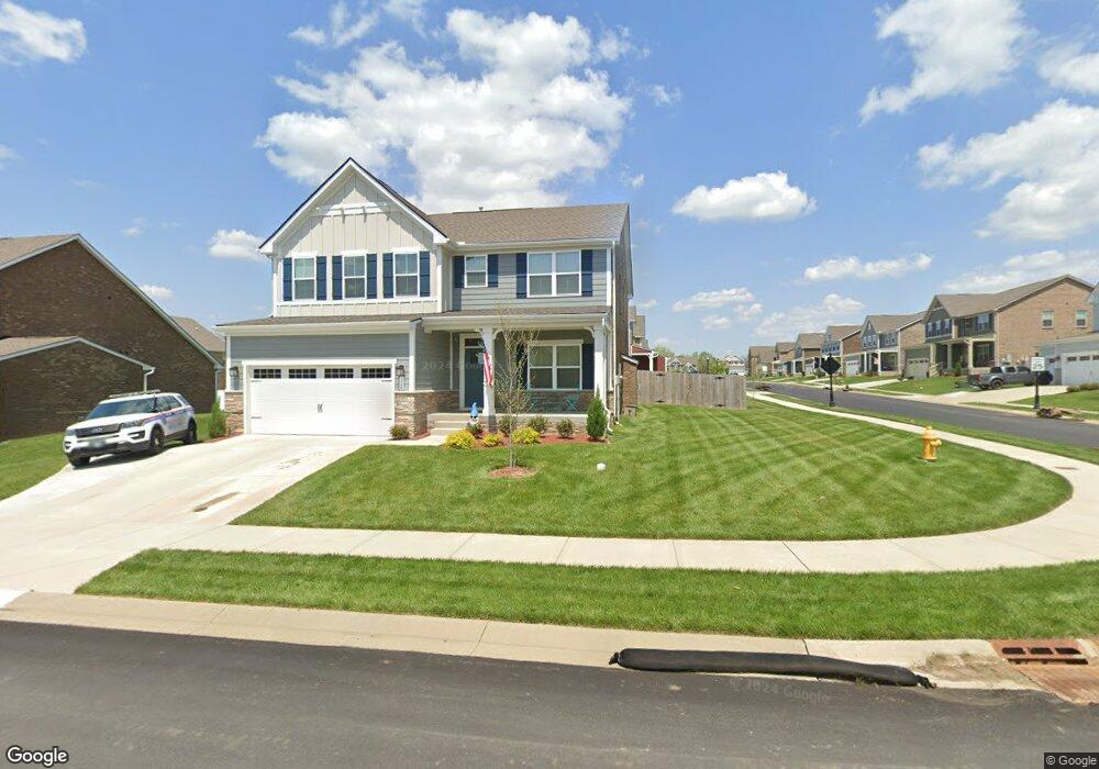
116 Bristol Dr Gallatin, TN 37066
Estimated Value: $546,205 - $613,000
4
Beds
4
Baths
2,793
Sq Ft
$206/Sq Ft
Est. Value
About This Home
This home is located at 116 Bristol Dr, Gallatin, TN 37066 and is currently estimated at $574,301, approximately $205 per square foot. 116 Bristol Dr is a home with nearby schools including Howard Elementary School, Rucker Stewart Middle School, and Station Camp High School.
Ownership History
Date
Name
Owned For
Owner Type
Purchase Details
Closed on
Jul 12, 2024
Sold by
Opendoor Property Trust
Bought by
Samples James G and Samples Tamara C
Current Estimated Value
Purchase Details
Closed on
Apr 30, 2024
Sold by
Lara Russell Jude and Lara Amie
Bought by
Opendoor Property Trust
Purchase Details
Closed on
Sep 10, 2020
Sold by
Nvr Inc
Bought by
Lara Russell Jude and Lara Amie
Home Financials for this Owner
Home Financials are based on the most recent Mortgage that was taken out on this home.
Original Mortgage
$344,593
Interest Rate
2.9%
Mortgage Type
VA
Purchase Details
Closed on
May 24, 2020
Sold by
Fairway Farms Development Gp
Bought by
Nvr Inc
Create a Home Valuation Report for This Property
The Home Valuation Report is an in-depth analysis detailing your home's value as well as a comparison with similar homes in the area
Home Values in the Area
Average Home Value in this Area
Purchase History
| Date | Buyer | Sale Price | Title Company |
|---|---|---|---|
| Samples James G | $525,000 | Tennessee Title | |
| Opendoor Property Trust | $496,100 | None Listed On Document | |
| Lara Russell Jude | $368,895 | None Available | |
| Nvr Inc | $63,370 | None Available |
Source: Public Records
Mortgage History
| Date | Status | Borrower | Loan Amount |
|---|---|---|---|
| Previous Owner | Lara Russell Jude | $344,593 |
Source: Public Records
Tax History Compared to Growth
Tax History
| Year | Tax Paid | Tax Assessment Tax Assessment Total Assessment is a certain percentage of the fair market value that is determined by local assessors to be the total taxable value of land and additions on the property. | Land | Improvement |
|---|---|---|---|---|
| 2024 | $2,097 | $147,600 | $20,000 | $127,600 |
| 2023 | $2,826 | $92,600 | $15,025 | $77,575 |
| 2022 | $2,836 | $92,600 | $15,025 | $77,575 |
| 2021 | $1,243 | $92,600 | $15,025 | $77,575 |
| 2020 | $1,243 | $92,600 | $15,025 | $77,575 |
Source: Public Records
Map
Nearby Homes
- 292 Grassy Glen Dr
- 638 Wassil Dr
- 281 Grassy Glen Dr
- 149 Putter Point Dr
- 806 Warrington Ct
- 3023 Duvall Dr
- The Caldwell Plan at Winston Place
- The Harrington Plan at Winston Place
- The Benson II Plan at Winston Place
- The Manchester II Plan at Winston Place
- The McGinnis Plan at Winston Place
- The Langford Plan at Winston Place
- The Piedmont Plan at Winston Place
- The Braselton II Plan at Winston Place
- 559 Becks Place
- 505 Coffee Ct
- 156 Hackney Ln
- 192 Summerlin Dr
- 205 Summerlin Dr
- 180 Summerlin Dr
- 116 Meyrick Dr
- 440 Rosy Dale Dr
- 440 Rosy Dale Dr
- 440 Rosy Dale Dr Unit 1091
- 433 Rosy Dale Dr
- 428 Rosy Dale Dr
- 429 Rosy Dale Dr
- 107 Meyrick Dr
- 444 Rosy Dale Dr
- 124 Meyrick Dr
- 103 Bristol Dr
- 424 Rosy Dale Dr
- 631 Wassil Dr
- 631 Wassil Dr
- 647 Wassil Dr
- 425 Rosy Dale Dr
- 445 Rosy Dale Dr
- 448 Rosy Dale Dr
- 627 Wassil Dr
- 651 Wassil Dr