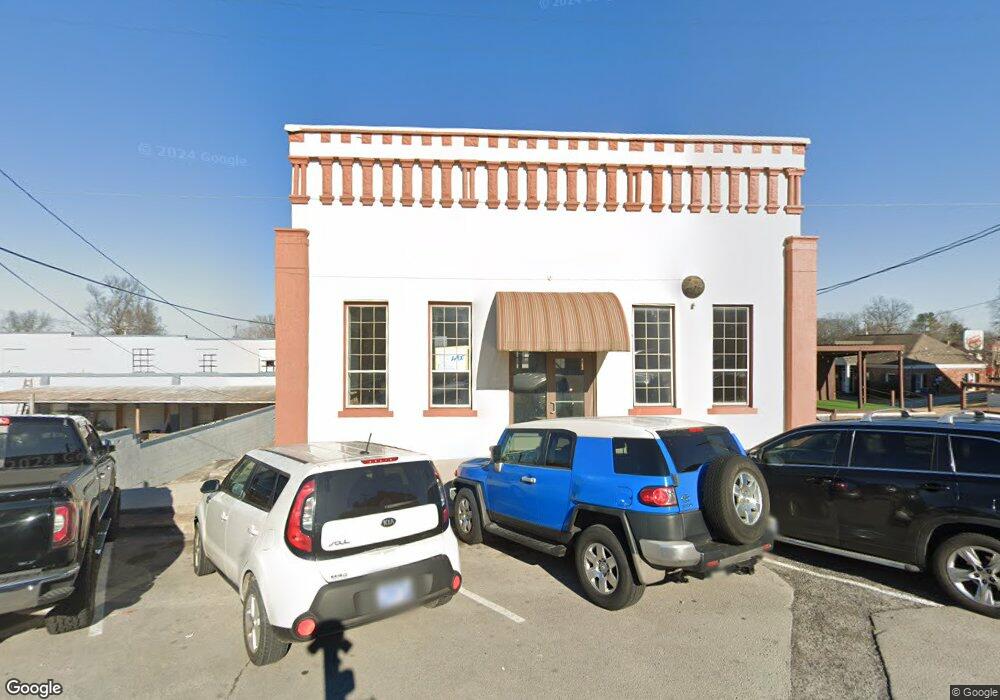
116 N College St Winchester, TN 37398
Estimated Value: $325,759
--
Bed
3
Baths
5,472
Sq Ft
$60/Sq Ft
Est. Value
About This Home
This home is located at 116 N College St, Winchester, TN 37398 and is currently estimated at $325,759, approximately $59 per square foot. 116 N College St is a home located in Franklin County with nearby schools including North Middle School, Franklin County High School, and Winchester Christian Academy.
Ownership History
Date
Name
Owned For
Owner Type
Purchase Details
Closed on
Oct 31, 2023
Sold by
Smith Joe W and Smith Kim P
Bought by
Winchester Downtown Project Corp
Current Estimated Value
Purchase Details
Closed on
Jun 22, 2017
Sold by
Ingle John
Bought by
Smith Joe W and Smith Kim P
Purchase Details
Closed on
Jan 6, 2006
Sold by
Kerman William O Estate
Bought by
Ingle John G
Purchase Details
Closed on
Feb 10, 1983
Bought by
Bailey Stephen P and Bailey David G
Purchase Details
Closed on
Jan 1, 1977
Purchase Details
Closed on
May 10, 1974
Create a Home Valuation Report for This Property
The Home Valuation Report is an in-depth analysis detailing your home's value as well as a comparison with similar homes in the area
Home Values in the Area
Average Home Value in this Area
Purchase History
| Date | Buyer | Sale Price | Title Company |
|---|---|---|---|
| Winchester Downtown Project Corp | $299,000 | Sovereign Title | |
| Smith Joe W | $57,500 | -- | |
| Ingle John G | $63,000 | -- | |
| Bailey Stephen P | -- | -- | |
| -- | $27,000 | -- | |
| -- | -- | -- |
Source: Public Records
Tax History Compared to Growth
Tax History
| Year | Tax Paid | Tax Assessment Tax Assessment Total Assessment is a certain percentage of the fair market value that is determined by local assessors to be the total taxable value of land and additions on the property. | Land | Improvement |
|---|---|---|---|---|
| 2024 | $1,729 | $67,240 | $18,640 | $48,600 |
| 2023 | $1,729 | $67,240 | $18,640 | $48,600 |
| 2022 | $1,695 | $67,240 | $18,640 | $48,600 |
| 2021 | $759 | $67,240 | $18,640 | $48,600 |
| 2020 | $1,047 | $29,640 | $7,600 | $22,040 |
| 2019 | $1,047 | $29,640 | $7,600 | $22,040 |
| 2018 | $986 | $29,640 | $7,600 | $22,040 |
| 2017 | $986 | $29,640 | $7,600 | $22,040 |
| 2016 | $968 | $29,080 | $5,000 | $24,080 |
| 2015 | $950 | $29,080 | $5,000 | $24,080 |
| 2014 | $951 | $29,090 | $0 | $0 |
Source: Public Records
Map
Nearby Homes
- 0 River Watch Way Unit RTC3032964
- 0 River Watch Way Unit RTC3032408
- 0 River Watch Way Unit RTC3032406
- 203 Campfire Ct
- 209 N Jefferson St
- 201&203 3rd Ave NE
- 203 3rd Ave NE
- 211 S Porter St
- 213 S Porter St
- 215 S Porter St
- 311 N Jefferson St
- 303 N Porter St
- 0 N Porter St
- 105 N Shephard St
- 510 N Porter St
- 301 N Shephard St
- 109 N Shephard St
- 803 S Shephard St
- 103 Lisa Cir
- 0 Milton Ln
- 229 Dinah Shore Blvd
- 107 N Porter St Unit 6
- 107 N Porter St Unit 7
- 107 N Porter St
- 209 2nd Ave NE
- 205 2nd Ave NE
- 203 2nd Ave NE
- 201 2nd Ave NE
- 207 2nd Ave NE
- 211 2nd Ave NE
- 213 2nd Ave NE
- 120 N Jefferson St
- 215 2nd Ave NE
- 2 S College St
- 1 S College St
- 4 S College St
- 117 1st Ave NE
- 6 S College St
- 6 Hwy 41-A
- 3 S College St