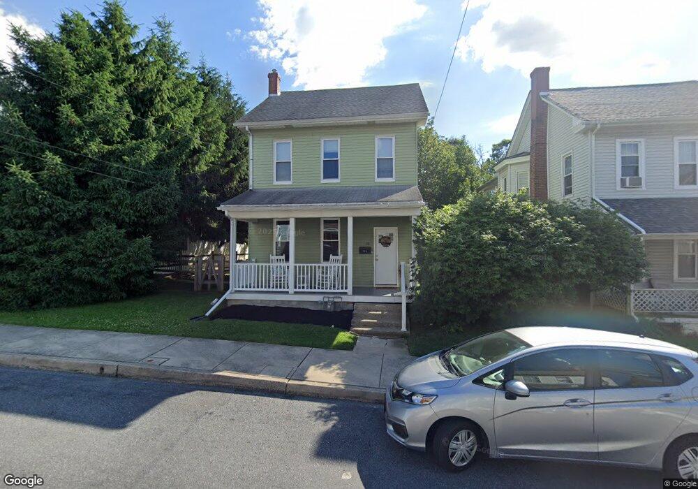
116 S 5th St Emmaus, PA 18049
Estimated Value: $210,000 - $314,000
3
Beds
2
Baths
1,740
Sq Ft
$148/Sq Ft
Est. Value
About This Home
This home is located at 116 S 5th St, Emmaus, PA 18049 and is currently estimated at $257,882, approximately $148 per square foot. 116 S 5th St is a home located in Lehigh County with nearby schools including Lincoln Elementary School, Lower Macungie Middle School, and Emmaus High School.
Ownership History
Date
Name
Owned For
Owner Type
Purchase Details
Closed on
Oct 31, 2019
Sold by
Schnellman David P
Bought by
Providence Investment Group Llc
Current Estimated Value
Purchase Details
Closed on
Dec 6, 2018
Sold by
Shafer Allison J and Youse Susan Joan
Bought by
Schnellman David P
Purchase Details
Closed on
Mar 19, 2015
Sold by
Youse Susan Joan
Bought by
Shafer Allison J
Purchase Details
Closed on
Mar 20, 2013
Sold by
Shafer Helen
Bought by
Shafer Allison J
Purchase Details
Closed on
Oct 27, 1971
Bought by
Shafer Helen F
Create a Home Valuation Report for This Property
The Home Valuation Report is an in-depth analysis detailing your home's value as well as a comparison with similar homes in the area
Home Values in the Area
Average Home Value in this Area
Purchase History
| Date | Buyer | Sale Price | Title Company |
|---|---|---|---|
| Providence Investment Group Llc | $104,100 | None Available | |
| Schnellman David P | $55,000 | None Available | |
| Shafer Allison J | $33,333 | None Available | |
| Shafer Allison J | $32,333 | -- | |
| Shafer Helen F | $17,000 | -- |
Source: Public Records
Tax History Compared to Growth
Tax History
| Year | Tax Paid | Tax Assessment Tax Assessment Total Assessment is a certain percentage of the fair market value that is determined by local assessors to be the total taxable value of land and additions on the property. | Land | Improvement |
|---|---|---|---|---|
| 2025 | $4,925 | $139,800 | $23,500 | $116,300 |
| 2024 | $4,511 | $139,800 | $23,500 | $116,300 |
| 2023 | $4,423 | $139,800 | $23,500 | $116,300 |
| 2022 | $4,277 | $139,800 | $116,300 | $23,500 |
| 2021 | $4,170 | $139,800 | $23,500 | $116,300 |
| 2020 | $4,105 | $138,800 | $23,500 | $115,300 |
| 2019 | $3,995 | $138,800 | $23,500 | $115,300 |
| 2018 | $3,844 | $138,800 | $23,500 | $115,300 |
| 2017 | $3,726 | $138,800 | $23,500 | $115,300 |
| 2016 | -- | $138,800 | $23,500 | $115,300 |
| 2015 | -- | $138,800 | $23,500 | $115,300 |
| 2014 | -- | $138,800 | $23,500 | $115,300 |
Source: Public Records
Map
Nearby Homes
- 521 Wood St
- 618 Broad St
- 569 Chestnut St Unit 571
- 659 Broad St
- 543 Long St
- 657 Walnut St
- 120 N 2nd St
- 118 N 2nd St
- 339 Delong Ave Unit 343
- 97 Chestnut Hill Rd
- 101 E George St
- 4109 Eveningstar Rd
- 3430 Gentlewind Way Unit IC 109
- 558 Beechwood St
- 4088 Eveningstar Rd
- 340 Chestnut Hill Rd
- 3601 Country Club Rd
- 529 Dalton St Unit 539
- 2571 Brunner Rd
- 540 E Greenleaf St